Caribbean Geography

ISLANDS, ISLETS AND CAYS:Overall the Caribbean is comprised of more than 7,000 islands. That number includes islets (very small rocky islands); cay's (small, low islands composed largely of coral or sand) and a few inhabited reefs: See Belize.
The largest islands in the Caribbean are Cuba, Jamaica,Hispaniola (divided into the two separate political units of Haiti and the Dominican Republic), and Puerto Rico.
THE ANTILLES: The majority of the Caribbean islands (called the West Indies) form a large arc extending eastward from the Yucatan Peninsula of Mexico and south from the Floridapeninsula in the United States, ending off the northeastern coastline of South America.
The Lesser Antilles, are part of the Antilles, which together with the Bahamas, the Cayman Islands, the Turks and Caicos and Greater Antilles all form the West Indies.
The Lesser Antilles begin to the east of Puerto Rico. This long chain of smaller islands, bordered in the east by the Atlantic Ocean, curve southward, terminating in Trinidad just off the northern coast of Venezuela.
Those Lesser Antilles are subdivided into the Leeward Islands group in the north and the Windward Islands group in the south. Also included in the Antilles are the Leeward Antilles consisting of Aruba, Bonaire, Curacao and a small group of Venezuelan islands.
VOLCANOES: Most of the Caribbean is volcanic in origin, and many of the smaller (as well as larger) islands have a central volcanic peak or a mountainous interior.
Visual evidence of that ancient volcanic activity can be seen on the black (volcanic) sand beaches of some of the islands like Dominica and Puerto Rico.
There is ongoing seismic activity in the Caribbean, as a number of volcanoes are considered active; they include Mt. Soufriere on St. Lucia, as well as those in Dominica, Grenada and St. Vincent.
MOUNTAINS: A number of significant mountain ranges stretch across the Caribbean, specifically in Cuba, Hispaniola, Jamaica, and Trinidad and Tobago. The highest point in the Caribbean is Pico Duarte at 3098 m (10,164 ft), located on the island of Hispaniola, in the Dominican Republic.
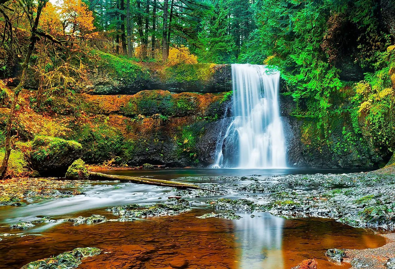
RAINFORESTS:Rainforests are found across the Caribbean, with those on Dominica and Jamaica, the most prominent. Most islands have several (small) waterfalls, normally located in the higher elevations.
CORAL REEFS: The Caribbean is home to about 9% of the world's coral reefs, covering about 52,000 sq km (20,000 sq miles). These reefs are important geographical features and islands like Cozumel are world famous for same.
RIVERS AND LAKES: There are a scattering of small lakes and rivers across the Caribbean, with the most significant ones on the islands of Cuba, Hispaniola and Trinidad and Tobago.
The largest lake in the Caribbean is Lake Enriquillo in the Dominican Republic at 265 sq km (102 sq miles). Other lakes of note are located in Cuba; Laguna de Leche at 67.2 sq km (25.9 sq mi), and the man-made Zaza Reservoir, at 113.5 sq km (43.8 sq mi).
As for rivers, there are over 400 relatively small ones in the Caribbean, as well as many narrow streams that frequently run dry in summer. The longest river on a Caribbean Island is in Cuba, where the Cauto flows for 230 mi (370 km) from its source in the Sierra Maestra.
BODIES OF WATER: The major bodies of water in the Caribbean include the Atlantic Ocean, the Caribbean Sea, and to a smaller extent, the Gulf of Mexico.
The Caribbean Sea itself is one of the largest salt water seas on the planet with an area of about 2,754,000 sq km (1,063,000 sq. miles). Its deepest point is the Cayman Trough, between the Cayman Islands and Jamaica, at 7,686 m (25,220 ft) below sea level.