Geography Statistics of Caribbean
- Overall Size: 2,754,000 sq km (1,063,000 sq miles)
- Land Area: 239,681 sq km (92,541 sq miles)
- Water: 2,514,319 sq km (970,459 sq miles)
- Percent of Earth's Land Surface: 0.16%
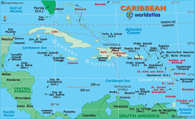
- Highest Point: Pico Duarte
3098 m (10,614 ft) (see map) - Lowest Point: Lake Enriquillo
(-39 m) (-128 ft) (see map) - Deepest Point: Cayman Trough
7,686 m (25,220 ft) (see map) - Horizontal Width: 2,197 km (1,365 miles) from Cancun, Mexico, east to San Juan, Puerto Rico (see map)
- Vertical Length: 1,799 km (1,118 miles) from Miami, Florida, southeast to Oranjestad, Aruba (see map)
- Caribbean Countries (by land area)
- Cuba: 110,860 sq km
- Dominican Republic: 48,730 sq km
- Haiti: 27,560 sq km
- Jamaica: 10,830 sq km
- Bahamas: 10,010 sq km
- Trinidad and Tobago: 5,128 sq km
- Dominica: 754 sq km
- St. Lucia: 616 sq km
- Antiqua: 443 sq km
- Barbados: 431 sq km
- St Vincent 389 sq km
- Grenada: 344 sq km
- St. Kitts and Nevis: 261 sq km
- Land Area: (all countries)
Note: Lengths and widths are point-to-point, straight-line measurements from a Mercator map projection, and will vary some using other map projections