9 Most Scenic Drives in Virginia
Virginia's scenic drives span the rolling ridgelines of the Blue Ridge Mountains and the coastal waterways of the Chesapeake Bay. The Blue Ridge Parkway follows the crest of the mountains for hundreds of miles. The Colonial Parkway links Jamestown, Williamsburg, and Yorktown through the forested corridor between the York and James Rivers. Along the Crooked Road, 300 miles of Appalachian Mountain roads connect museums, performance venues, and live music jams that define the heart of American old-time, bluegrass, and country music. Whether you have a full week or just an afternoon, the nine routes below make the most of every mile.
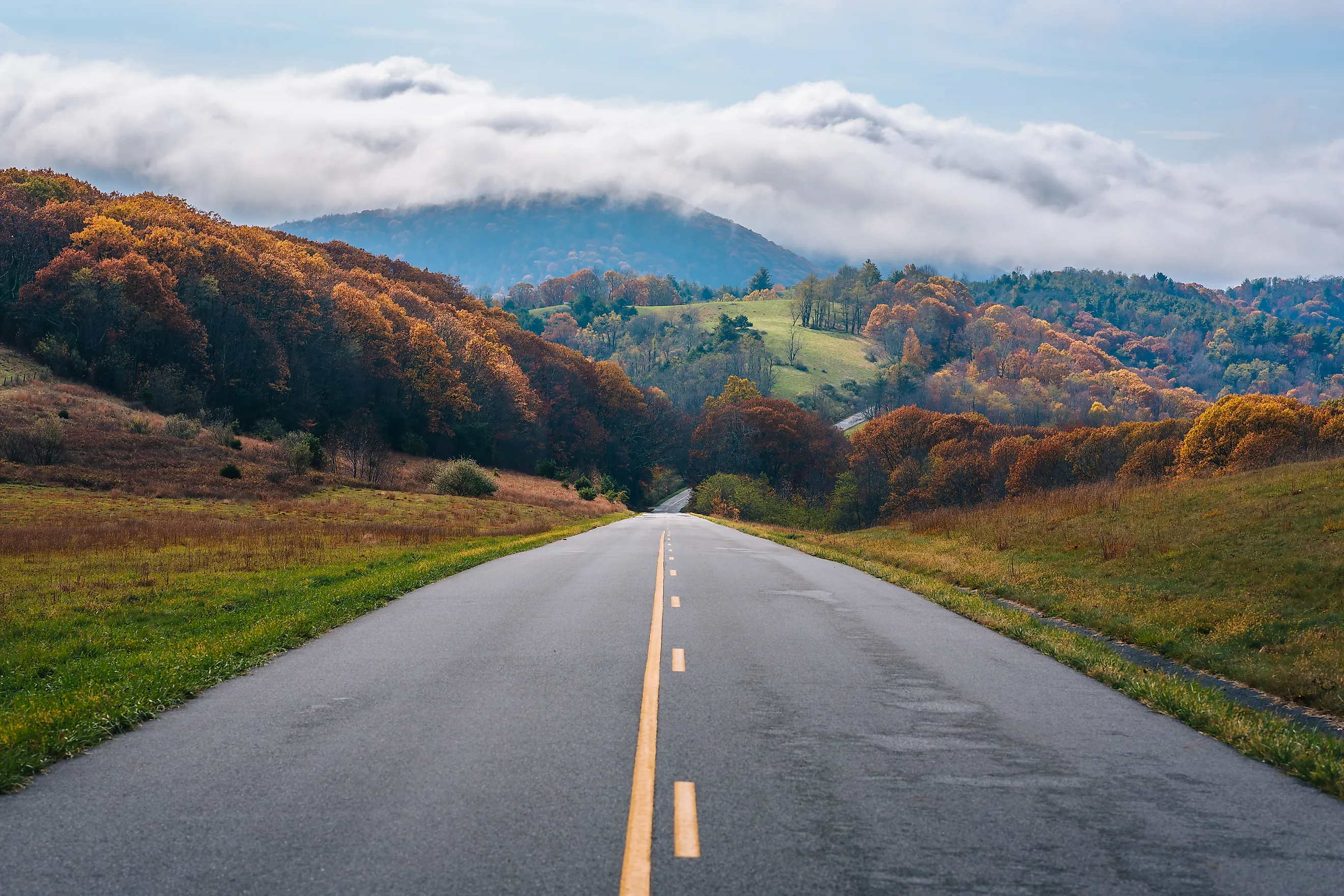
Blue Ridge Parkway

The Blue Ridge Parkway stretches 469 miles through Virginia and North Carolina, connecting Shenandoah National Park in the north to Great Smoky Mountains National Park in the south. The Virginia section begins at Rockfish Gap near Waynesboro and runs south along the Blue Ridge Mountains. The parkway's overall highest point sits at Richland Balsam in North Carolina at 6,047 feet; in Virginia, elevations peak around 3,950 feet near Apple Orchard Mountain. Virginia highlights include Humpback Rocks, the Peaks of Otter area near Bedford, and the Roanoke Mountain Loop. Scenic overlooks and visitor centres are distributed along the route. Spring brings wildflower blooms, fall brings peak foliage. The speed limit is generally 45 mph, and while the parkway is open year-round, sections close during winter storms.
Skyline Drive

Skyline Drive is the only public road running through Shenandoah National Park, covering 105 miles from Front Royal in the north to Waynesboro in the south (where it connects to the Blue Ridge Parkway). The 35 mph speed limit and 75 scenic overlooks make this a deliberately slow drive. Driving straight through takes about three hours; most visitors budget a full day with stops. The road has four entrances (Front Royal, Thornton Gap, Swift Run Gap, and Rockfish Gap), so driving the entire length is optional. Mary's Rock Tunnel at mile 32.2 has a maximum clearance of 12 feet 8 inches, a limitation worth noting for RVs and trailers.

Fall foliage is Skyline Drive's signature season, typically peaking in mid-to-late October. Wildlife is abundant, with white-tailed deer, black bears, and wild turkeys all commonly sighted. Stops along the way include Stony Man (4,011 feet, the second-highest peak in Shenandoah and a popular short hike), offering views of the Shenandoah Valley and Massanutten Mountain to the west.
Colonial Parkway

The Colonial Parkway links Jamestown, Williamsburg, and Yorktown, three sites collectively known as the Historic Triangle. The 23-mile route runs along the York and James Rivers with no commercial traffic, billboards, or modern commercial development permitted. Jamestown is the site of the first permanent English settlement in North America (1607). Colonial Williamsburg recreates 18th-century Virginia colonial life through costumed interpreters and preserved buildings. Yorktown is where British General Charles Cornwallis surrendered to George Washington in October 1781, effectively ending the Revolutionary War's major combat phase. More than 16 scenic pullouts provide river views. The parkway includes one tunnel, completed in 1942, stretching 1,190 feet.
The Crooked Road: Virginia's Heritage Music Trail

The Crooked Road covers more than 300 miles through Southwest Virginia, winding through the heart of the Appalachian Mountains. The route crosses rolling hills, dense forests, and small mountain communities, with scenic overlooks throughout. The road's name reflects its winding character, so this is not a drive to rush.
The Crooked Road focuses on the roots of American music: country, bluegrass, old-time, and gospel. The trail links over 60 venues. Key stops include the Birthplace of Country Music Museum in Bristol (a Smithsonian affiliate covering the legendary 1927 Bristol Sessions, where Ralph Peer recorded the earliest commercial country music including the Carter Family and Jimmie Rodgers), the Carter Family Fold in Hiltons (preserving the Carter Family's performance tradition with live music and flat-foot dancing at A.P. Carter's original grocery store and performance hall), and the Ralph Stanley Museum in Clintwood (celebrating the life and career of bluegrass pioneer Dr. Ralph Stanley). Weekly jam sessions and scheduled live music occur at venues throughout the trail year-round.
Mount Rogers Scenic Byway

The Mount Rogers Scenic Byway is about 60 miles long, but the terrain demands at least three hours of driving time (more with stops). The byway winds through Jefferson National Forest and the Mount Rogers National Recreation Area in two sections: Section 1 runs from Troutdale to Konnarock along Virginia Route 603, and Section 2 runs from Damascus to Volney along US Route 58. The byway can be accessed from Interstate 81 via Marion (Exit 45), among other points.
Mount Rogers itself, at 5,729 feet, is Virginia's highest peak. Nearby Whitetop Mountain at 5,520 feet is the second-highest. The byway provides access to popular hiking trails including the Appalachian Trail and the Virginia Creeper Trail. Grayson Highlands State Park along the route is known for its free-roaming feral ponies, introduced in the 1970s to maintain the mountain balds. Higher elevation makes summer hiking comfortable when surrounding lowlands are hot. Winter conditions can change quickly.
George Washington Memorial Parkway

The George Washington Memorial Parkway follows the Potomac River for more than 25 miles, connecting sites tied to the first president and early American history. Managed by the National Park Service, the route opens at Mount Vernon (Washington's estate, now preserved and open for tours) in the south and extends north through Arlington and into Great Falls Park. Along the way, Arlington House (the Robert E. Lee Memorial) sits within Arlington National Cemetery, preserving the home Lee occupied before the Civil War.

Further along, the US Marine Corps War Memorial (also known as the Iwo Jima Memorial) honours Marines who have died in service since 1775, with its iconic flag-raising sculpture based on the 1945 Iwo Jima photograph. Great Falls Park preserves dramatic waterfalls and rugged cliffs along the Potomac River with hiking trails and scenic overlooks. Theodore Roosevelt Island is a quiet wooded memorial dedicated to the conservation-minded president. The parkway's first section opened in 1932 to mark the bicentennial of Washington's birth.
Chesapeake Bay Bridge-Tunnel

The Chesapeake Bay Bridge-Tunnel is a 17.6-mile crossing that is both stunning and intimidating for some drivers. The crossing combines a series of low-level bridges, causeways, and two tunnels (each about one mile long) that dip under the shipping channels so that ocean-going vessels can pass overhead. The northern end sits near Cape Charles on the Eastern Shore, and the southern end is in Virginia Beach. The crossing is a toll road.
Beyond its sightseeing appeal, the Bridge-Tunnel is a major transportation route between southeastern Virginia and the Eastern Shore. Traffic can be heavy on weekends and holidays. The Welcome Center at the northern end includes a scenic overlook popular for fishing and birdwatching, and U.S. Navy ships can often be seen passing beneath. The complex has a gift shop, vending machines, and restrooms. The route uses a mix of two-lane and four-lane sections depending on the segment.
US Route 58

US Route 58 is the longest east-to-west highway corridor in Virginia, at 508 miles from Virginia Beach to the Tennessee state line at Cumberland Gap. The route spans the full geographical range of the state, starting at the Atlantic Ocean and ending in the Appalachian Mountains, passing through the Tidewater, Piedmont, Blue Ridge foothills, and finally the Appalachian Plateau. Notable stops along the way include the Blue Ridge Parkway near Meadows of Dan and Grayson Highlands State Park (home to the feral ponies mentioned earlier).
Historic Abingdon is a highlight stop, home to the Barter Theatre (Virginia's State Theatre since 1946, famous for accepting produce as payment during the Great Depression) and the eastern end of the Virginia Creeper Trail, a 34-mile rail-trail popular for biking. Chateau Morrisette winery and Mabry Mill along the Blue Ridge Parkway provide classic regional stops, with mountain overlooks throughout the middle portion of the route.
Appalachian Waters Scenic Byway

The Appalachian Waters Scenic Byway follows Route 39 from Lexington, Virginia, into West Virginia, ending near Summersville. The route is a winding mountain road, so slow driving and frequent stops are the right approach. Much of the drive passes through George Washington National Forest, with stops for hiking, fishing, camping, and other outdoor recreation. Goshen Pass is the signature stop: a dramatic Maury River gorge known for hiking, wildlife viewing, and whitewater paddling.
True to its name, the byway offers access to water-based recreation. Along and near Route 39, travellers can find kayaking, swimming, and fishing on the Cowpasture and Jackson rivers. Lake Moomaw, reached by a short detour from the Warm Springs area, offers boating, swimming, and lakeside recreation. Douthat State Park is another worthwhile side trip, with a swimming beach, boating, fishing, and trails.
Nine Drives, One Virginia
From Chesapeake Bay coastal bridges to Blue Ridge mountain crests and Appalachian music trails, these nine routes reach every corner of Virginia's geography. The Blue Ridge Parkway and Skyline Drive cover the mountain spine; the Colonial Parkway and George Washington Memorial Parkway trace the colonial and federal history; the Crooked Road hits America's country-music roots; US 58 crosses the whole state east-to-west. Whether the goal is a weekend trip or a two-week loop, Virginia's scenic drives are among the most densely rewarding in the country.