Driving Over (And Under) The Chesapeake Bay Via The World's Longest Bridge-Tunnel Complex
The United States is certainly no slouch when it comes to world record-breaking feats of engineering. The planet’s longest continuous bridge over water? That’s in Louisiana, the 24-mile-long Lake Pontchartrain Causeway north of New Orleans. The deepest highway tunnel in North America? Boston's Big Dig created the Ted Williams Tunnel, reaching depths of 90 feet below the surface.
Only in Virginia, though, can you find a record-breaking project that combines both underground and overground engineering elements: the Chesapeake Bay Bridge-Tunnel (CBBT). The world's longest bridge-tunnel complex, the CBBT, solved the centuries-old problem of how to connect the southern tip of the Delmarva Peninsula (aka, Virginia’s Eastern Shore) to the mainland and the state’s Coastal Virginia area, home to the communities of Virginia Beach and Norfolk.

Stretching nearly 18 miles over and under America’s largest bay and now in its seventh decade, this ambitious project continues to serve as one of the Mid-Atlantic region’s most important transport routes. And it’s also still evolving, with new construction work underway to improve its infrastructure and ensure its longevity.
A Bold Solution to an Ancient Barrier

As I recently discovered, Virginia’s Eastern Shore feels a world apart from the rest of the “Old Dominion” state. Crossing Maryland's Chesapeake Bay Bridge to this narrow peninsula, it was easy to grasp the age-old dilemma that Virginians once faced: how to circumvent Chesapeake Bay and connect their fertile Eastern Shore with the rest of the state?
A byproduct of the last ice age, 10,000 years ago, the Eastern Shore was separated from the mainland after rising seas flooded the Susquehanna River valley. For centuries, the Bay had forced travelers to resort to sometimes primitive ferries, a journey that could take hours… or sometimes not at all if the weather didn’t cooperate.
By the 1950s, with automobile travel booming and America’s navy headquarters at Naval Station Norfolk expanding, Virginia found itself in even greater need of a permanent connection between its isolated Eastern Shore and the Hampton Roads region. The solution? Yup, the Chesapeake Bay Bridge-Tunnel.
Building the World’s Longest Bridge-Tunnel
At the time, the Chesapeake Bay was considered by most to be an insurmountable hurdle. Not only did engineers have to deal with the region’s unique topography, but there was also the challenge of maintaining shipping access to one of the East Coast’s busiest ports in Baltimore, as well as its main naval facilities, during construction. The best possible answer, engineers argued, was to build high-level bridges across most of the bay, then plunge the road beneath the water at two critical shipping channels.

Construction started in 1960, and by the time the project was completed in 1964, this revolutionary bridge-tunnel system comprised four main components: two mile-long tunnels, two high-level bridges, four artificial islands, and multiple miles of low-level trestle.
Here’s how it works:
- At the CBBT’s north end, the 5,450-foot-long Chesapeake Channel Tunnel travels under the bay's main shipping lane, while the slightly longer Thimble Shoal Tunnel extends 5,738 feet beneath the Thimble Shoal shipping channel.
- Each tunnel connects to the surface via man-made islands constructed from millions of tons of sand and rock.
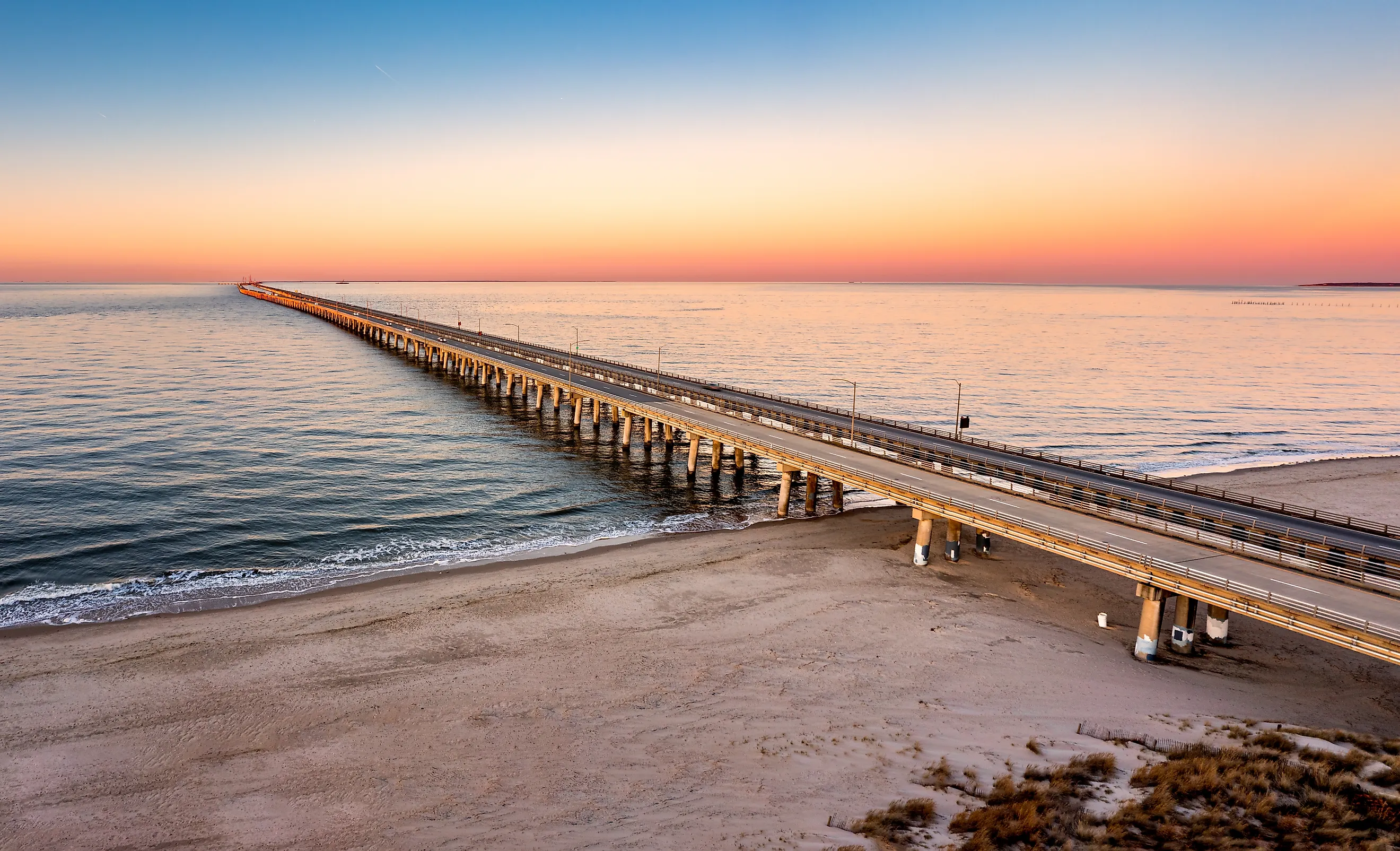
- Between these underwater sections, vehicles travel on bridges that rise as high as 75 feet above the high-water mark, providing ample clearance for shipping. The North Channel Bridge spans 858 feet, while the Fisherman Inlet Bridge stretches 2,690 feet.
The remaining distance consists of low-level trestle bridges that run just 30 feet above the water, close enough that if you wind your window down, you’ll even smell the salt air.
Transforming Virginia's Economy
When the CBBT opened to the public on April 15, 1964, it had cost the princely sum of nearly $200 million… about $2 billion in today’s dollars. Sadly, there was also a human cost. The construction claimed the lives of seven construction workers, a tragic loss that’s memorialized at the complex's southern entrance.
Despite its cost, the CBBT's impact on Virginia has been astounding. Before its construction, the Eastern Shore's agricultural products, such as potatoes, tomatoes, and seafood, faced lengthy and expensive journeys to reach markets across the Bay. Not only did the bridge-tunnel cut travel times from several hours to just 23 minutes, but it also opened new economic opportunities for farmers, watermen, and even sightseers.

Tourism flourished as beach-bound travelers discovered they could reach Virginia Beach from points north without the long detour through Richmond. It worked the other way around, too, with Virginians now able to explore such hitherto hard-to-get-to destinations as Cape Charles, Onancock, and even Chincoteague with its amazing beaches and famous wild ponies.
Building for the Future
Tourism dollars aside (2024 alone saw an estimated $261 million pumped into the Eastern Shore’s economy), drivers using this remarkable crossing spend over $50 million annually in tolls; that’s money for everything from maintenance and improvements to new construction, ensuring this vital transport link will remain operational for decades to come.

As I found out while traveling across the CBBT, new improvements to this shining example of American engineering are well underway. A massive expansion project began in 2017 to add a second parallel tunnel at Thimble Shoal by 2028. This $756 million project addresses the bridge-tunnel's most significant vulnerability: the current two-lane tunnels create bottlenecks during peak travel times, which are especially bad if one tunnel requires maintenance.
The new tunnel will feature two new southbound lanes, while the existing tunnel will handle northbound vehicles, effectively doubling capacity at this crucial chokepoint. In the meantime, as I witnessed for myself, traffic keeps on moving at a steady pace.
Driving Over (and Under) America’s Biggest Bay
If, like me, your bucket list involves visiting some of the United States’ most impressive man-made landmarks, then the Chesapeake Bay Bridge-Tunnel is definitely for you. What’s it like to drive? While it’s nowhere near as long as epic road trips along routes like the Oversea Highway in the Florida Keys, it can be just as much fun if you include a few Eastern Shore highlights in your itinerary.

While I took my time with fun overnight stays in Chincoteague and Onancock (more on those another time!), you can get to the CBBT “pedal-to-the-metal” from Washington, D.C., in around four hours, whether you choose to tackle it from the north as I did or from the south.
Whichever way you do it, be sure to stop at the Chesapeake Bay Bridge Scenic Overview on the Bay’s north shore (it’s just a minute or two from the southbound toll booths). Seeing the bridge cross over Fisherman Island before curving westward, only to disappear underwater, and then reappear further on, is breathtaking. So, too, are the northwest views over the Bay.

If you’ve got time before hitting the tolls, plan to stop at the Eastern Shore of Virginia National Wildlife Refuge. This 1,200-acre preserve not only serves as a crucial stopover for migratory birds following the Atlantic Flyway, but it’s also where you can pick up the Wise Point Trail. This 1.5-mile path leads to Wise Point, the southern-most tip of the peninsula, for another CBBT viewpoint. It’s well worth the hour-long round-trip walk.
Conclusion: Engineering, Economy, and Driving the Bay Link
The incredible Chesapeake Bay Bridge-Tunnel is well worth including on your list of Virginia must-sees. If you plan on adding it to your own bucket list (and you should), here are a few key facts about the world's longest bridge-tunnel complex:
- Total Length: 17.6 miles
- Opened April 15, 1964, after four years of construction
- Cost: $200 million (approximately $2 billion in today's dollars)
- Components: Two one-mile tunnels, four artificial islands, two high-level bridges, and miles of low-level trestle
- Tunnel Depths: Thimble Shoal Tunnel runs 5,738 feet; Chesapeake Channel Tunnel extends 5,450 feet
- Bridges rise up to 75 feet above mean high water
- Travel time: 23 minutes
- Revenues: Over $50 million in tolls collected annually
- Expansion: A $756 million second tunnel at Thimble Shoal is scheduled for completion in 2027 completion
The Chesapeake Bay Bridge-Tunnel is so much more than just a convenient route between Virginia's Eastern Shore and the mainland. It’s a one-of-a-kind driving experience that one minute sees you seemingly diving beneath huge freighters and naval vessels before resurfacing as you make your way above the surface of America’s biggest bay.