7 Great Road Trips to Take in Texas
A road trip through Texas can take many shapes. Back roads wind over limestone hills through the Hill Country and a climb leads into the volcanic heights of the Davis Mountains. A beachside cruise runs from Mustang Island to Galveston. Other routes pass Route 66 relics and Palo Duro Canyon overlooks. Still others cut through the pinewoods east of Bastrop and the immense horizons beyond Fort Davis. Listed from shortest to longest, each one shows a different side of Texas.
Hill Country (San Antonio to Llano)

The Hill Country offers a traveling experience unlike anything else in Texas, defined by rolling hills and cool spring-fed rivers. Beginning in San Antonio, the route follows I-10 to Boerne, where Main Street and the Boerne Historic District offer an early excuse to slow down. From there, FM 1376 rolls through limestone cuts, live oaks, and ranchland to Sisterdale, where the Sisterdale Dance Hall preserves the feel of an earlier Texas. Continuing north, the road reaches Luckenbach, where the famous Luckenbach Dance Hall and oak-shaded beer garden have made it one of the region’s most recognizable roadside stops.

From Luckenbach, Ranch Road 1376 leads into Fredericksburg, where Main Street’s limestone storefronts, bakeries, tasting rooms, and boutiques make a natural midpoint pause, anchored by the National Museum of the Pacific War. North of town, travelers can continue via dramatic Ranch Road 965 past Enchanted Rock State Natural Area, or take the more photogenic Willow City Loop via TX 16 and Ranch Road 1323, famed for wildflowers, granite outcrops, and long ranchland views. Both routes return to TX 16 for the final push into Llano, crossing the Llano River into a town known for its historic jail, museum, and “Deer Capital of Texas” nickname.
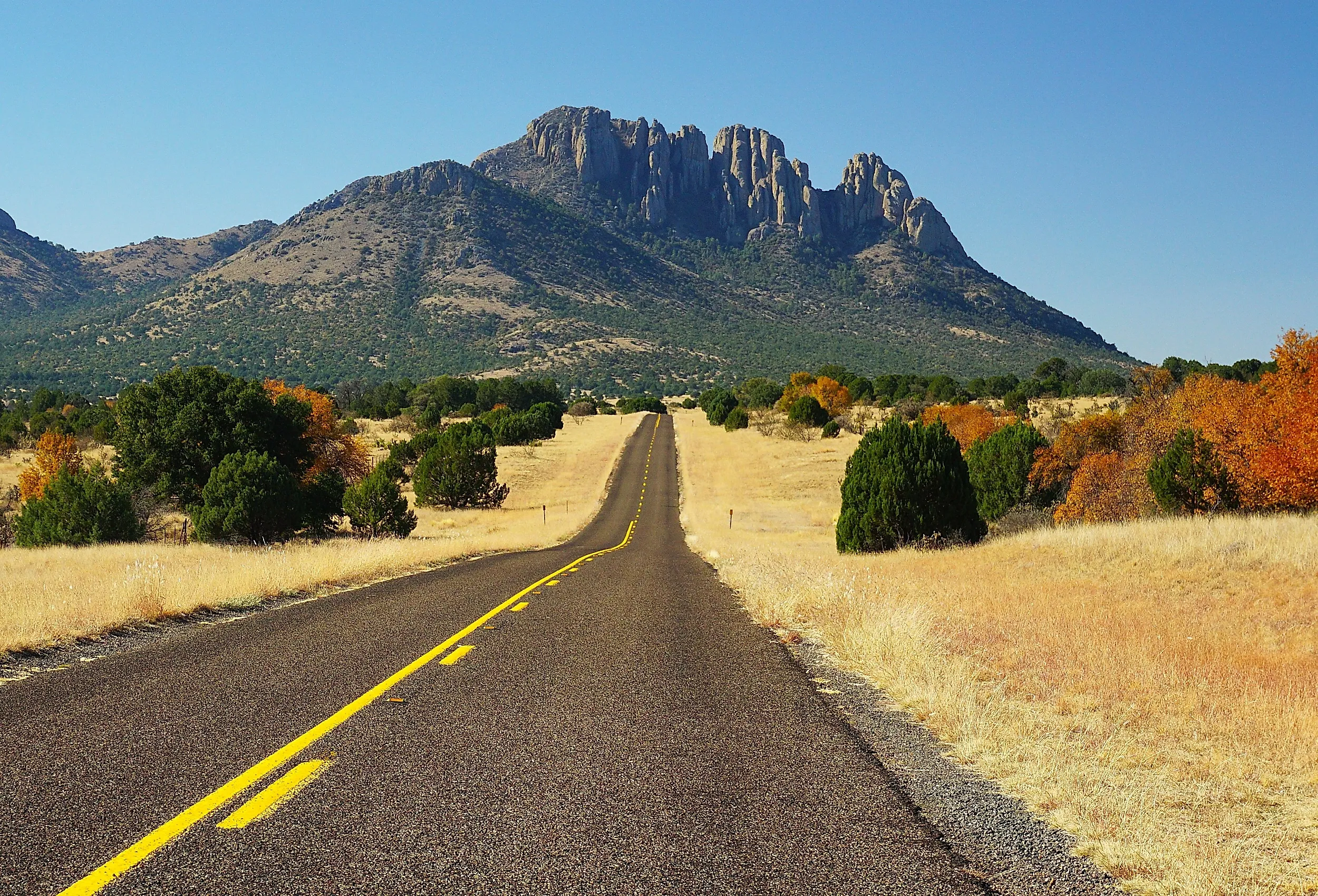
Davis Mountains (Alpine to Marfa via Fort Davis)

From the moment travelers leave Alpine on TX 118 north, this drive trades open ranchland for the rising silhouettes of the Davis Mountains, one of the most dramatic sky island ranges in West Texas. The road climbs steadily toward Fort Davis, with long views across high desert and volcanic rock that make this corner of Texas feel unlike anywhere else in the state. Before town, the Chihuahuan Desert Research Institute offers desert gardens, geology exhibits, and the Modesta Canyon trail system. A few miles farther, Fort Davis itself provides one of the region’s finest historic stops at Fort Davis National Historic Site, where restored quarters, parade grounds, and stone barracks tell the story of the frontier post that once guarded the San Antonio-El Paso Road. Nearby, the Davis Mountains State Park Interpretive Center offers sweeping overlooks and an excellent introduction to the landscape ahead.
From Fort Davis, TX 118 grows even more spectacular as it climbs toward the McDonald Observatory, twisting through piñon, juniper, and exposed volcanic ridges. The route then follows the scenic loop formed by TX 166, passing Balance Rock and circling Mount Livermore through ridgelines, canyons, and elevated desert basins before reconnecting with TX 118 south for the final run into Marfa. By the time the road drops out of the mountains into the immense horizons of the high Chihuahuan Desert, the journey feels far grander than its mileage suggests.
Big Bend Country (Marathon to Alpine via Terlingua)

This scenic loop through the heart of Big Bend Country begins in the railroad town of Marathon, heading south on US 385 into the open Chihuahuan Desert, where the pavement quickly narrows into long sightlines of gravel plains and distant mesas. About 40 miles south, the route passes through Persimmon Gap at Big Bend National Park’s north entrance, where limestone ridges mark the transition from ranchland into protected desert terrain. Continuing south on Main Park Road, the drive pushes deeper into the park toward Panther Junction, where the desert begins to fold into more rugged country shaped by ancient uplift and erosion.
At Panther Junction, the route turns west onto the park’s main road and connects with TX 118 toward Study Butte and Terlingua, with the Chisos Mountains rising darkly to the east and broad desert basins opening westward. Along the way, travelers can make a worthwhile detour onto the Ross Maxwell Scenic Drive for Sotol Vista, Mule Ears, Burro Mesa, and Santa Elena Canyon before returning to the main route. Approaching Terlingua, TX 118 passes turnoffs for the old mining district and the Starlight Theatre, where the remains of the Terlingua Ghost Town cluster beneath wide desert skies. From there, the road continues north across long, uninterrupted stretches of high desert toward Alpine, where the basin slowly lifts into higher grasslands and ranch country. By journey’s end, the land feels sparse and expansive, defined by desert scale and distant mountains.
Route 66 (Glenrio to Texola via Amarillo and Palo Duro Canyon)

Texas claims only a short stretch of historic Route 66, but what it lacks in length it makes up for in atmosphere. Beginning at the ghostly border town of Glenrio, the route follows Interstate 40 frontage roads that closely trace the original alignment through a landscape that feels suspended in time. Just beyond Glenrio lie abandoned trading posts and old pavement before the road reaches Adrian, proudly known as the midpoint of the Mother Road, 1,139 miles from both Chicago and Los Angeles. The MidPoint Café offers a fitting pause before the route continues through Vega and into Amarillo by way of the Sixth Street Historic District, where antique stores, murals, and classic diners line the old road.
Amarillo offers some of Route 66’s most recognizable attractions, including Cadillac Ranch and Bill’s Backyard Classics. From there, a nearly essential detour heads south to Palo Duro Canyon State Park, the “Grand Canyon of Texas,” where the flat plains suddenly give way to red cliffs, sweeping overlooks, and trailheads leading into rugged canyon country. Returning to I-40, the route resumes through Conway and Groom, where the immense Cross of Our Lord Jesus Christ rises beside the highway, before continuing into Shamrock, home to the restored Conoco Tower Station and U-Drop Inn. From there, it’s a short final run along frontage roads and old alignments to Texola, where weathered buildings mark the transition into Oklahoma.
El Camino Real (San Marcos to Nacogdoches)

The journey from San Marcos to Nacogdoches along the historic El Camino Real de los Tejas National Historic Trail follows a corridor that has guided travelers across Texas for centuries. Departing San Marcos, travelers pick up State Highway 21 on the east side of town, beginning a direct course that closely mirrors the trail’s original alignment. The road rolls through Caldwell County ranchland before nearing Bastrop, where Bastrop State Park’s dense loblolly pines provide a striking contrast to the drier terrain farther west. Continuing east on SH 21, the highway settles into a steady rhythm through broad pastureland, scattered ranch entrances, and long, gently curving stretches of pavement, carrying travelers through Bryan and College Station, home to Texas A&M University. Roadside markers, small-town squares, local cafés, and antique shops hint at the route’s Spanish colonial origins and offer frequent opportunities to pause.
Beyond Bryan, SH 21 passes through Madisonville and Alto as the landscape gradually shifts from open pasture to the thick pine forests of East Texas. Near the Davy Crockett National Forest, the highway threads through a quieter, more enclosed countryside of creeks, weathered farmsteads, and occasional clearings. Approaching Nacogdoches, historical markers and understated scenic pull-offs announce one of the oldest towns in Texas, where stops like Millard’s Crossing Historic Village and the preserved downtown district provide a fitting conclusion to a drive shaped by history and the slow unfolding of the Texas landscape.
Gulf Coast (Corpus Christi to Galveston)

Few drives in Texas feel as relaxed as this easy amble along the marshes and flatlands of the Gulf Coastal Plain. Starting in Corpus Christi, home to the USS Lexington and the Texas State Aquarium, the route follows the shoreline northeast, where salty air and wide skies set the tone. Drivers take TX 358 across the JFK Causeway, with the Laguna Madre spread out on both sides, then continue north on TX 361 along Mustang Island, passing the Padre Island National Seashore turnoff and a string of beach access points. In Port Aransas, travelers can stop at Roberts Point Park or the University of Texas Marine Science Institute before boarding the free ferry to Harbor Island, with dolphins often visible in the wake.

On the far side, TX 361 traces the coast through Aransas Pass and into Rockport, where the Fulton Mansion State Historic Site and Texas Maritime Museum offer a look into the region’s past. Continuing northeast, TX 35 hugs the bays, crossing causeways over Copano Bay and San Antonio Bay with broad views of oyster reefs and migratory birds, then passes through communities like Tivoli and Palacios. Near Bay City, the route continues toward Lake Jackson before turning onto TX 332 and the Bluewater Highway (CR 257) for the crossing at San Luis Pass, then follows FM 3005 along Galveston Island. The final stretch meets Seawall Boulevard in Galveston, where the Gulf opens beside a long ribbon of sand and the journey ends near the Pleasure Pier and the Strand.
Trans-Pecos (Del Rio to Van Horn)

It may not be the fastest route across West Texas, but the drive from Del Rio to Van Horn rewards those willing to trade speed for scenery. Leaving Del Rio on US 90, the road follows the Rio Grande’s rugged borderlands to Langtry, where the Judge Roy Bean Visitor Center offers a glimpse into frontier justice and the life of the self-styled “Law West of the Pecos.” Beyond Langtry, the highway stretches across wide-open desert through Comstock and on toward Marathon, a quiet outpost framed by increasingly mountainous scenery and known for the historic Gage Hotel.

From Marathon, US 90 continues northwest to Alpine, home to the Museum of the Big Bend, before carrying on west to Marfa, where contemporary art and the Marfa Lights Viewing Area have made the small town world-famous. Back on US 90, the journey presses across long, empty desert stretches to one of West Texas’s most unexpected roadside sights: Prada Marfa, the permanently installed art piece that resembles a luxury boutique stranded in the scrub. Past Valentine, the highway continues through stark, expansive terrain, distant ridges marking the horizon, before finally reaching Van Horn, gateway to Guadalupe Mountains National Park. Services are sparse, and fuel stops require planning, but the solitude, distance, and cinematic contrasts of the Trans-Pecos make this one of the most memorable drives in Texas.
To drive across Texas is to watch the state constantly reinvent itself through the windshield, as limestone hills give way to pine forests, desert basins rise into mountains, and prairie roads suddenly drop toward canyons or the sea. These seven routes connect far more than just towns and landmarks. They reveal the moods, textures, and immense distances that define Texas, gathering dance halls, ghost towns, canyon overlooks, ferry crossings, old highways, and empty horizons into a larger sense of place. They offer a clear, rewarding way to understand the scale, variety, and enduring appeal of the state.