11 Most Scenic Road Trips To Take In New Mexico
Take an adventure into the Old West and drive through the land of the ancient Pueblos people and their cliff dwellings, with the mighty Rocky Mountains waving from the northern parts of the state. Also, explore beautiful prairies and the Great Plains that extend to the eastern third to the Chaco Canyon and Shiprock of the Colorado Plateau in the northwestern part. New Mexico has one of the most diverse landscapes of any US state. Travel down one of the most amazing scenic drives the Old West offers. These are eleven road trips that you would enjoy for sure while you explore New Mexico.
Abo Pass Trail State Scenic Byway

The trail bridges the remains of Abo Pueblo on its eastern side to the town of Belen on the west and El Camino Byway to the Salt Missions Scenic Byway. The byway passes through beautiful vistas and desert landscapes, including views of the Manzano Mountains and the surrounding high desert terrain.
It closely runs through the edge of Sevilleta National Wildlife Refuge before it passes its way through the Manzanos and finally through the Abo Pass. The Abo Pass Trail has been historically significant for its role in the expansion of the westward development of the United States. The byway shows one of the few remaining panoramic views of the majestic Manzano Mountains and the untouched green plains that often act as a safe space for wildlife.
El Camino Real National Scenic Byway

The El Camino Real National Scenic Byway follows the original route of El Camino Real. It is popularly called the El Camino Real De Tierra Adentro (The Royal Road of the Interior Land), and it was initially meant for traders and pilgrims arriving at Plymouth Rock.
The byway starts north of Las Cruces in Fort Selden and stretches across the Jornada del Muerto desert before reaching Socorro. The road stretches from the Mesilla Valley to Ohkay Owingeh north of Santa Fe. Currently, the most used route is Interstate 25. However, the Real Byway gets you through scenic escapes that you may not see if you take the Interstate. The Caballo Lake, Elephant Butte Lake, Sevilleta, and Bosque del Apache are places you would want to take advantage of on your road trip. Many outdoor activities can be enjoyed at the Caballo Lake and the Elephant Butte Lake State Parks. The Bosque del Apache National Wildlife Refuge is significant for recreational activities.
Though the highway is a stretch for a long day trip, it offers various side locations to learn more about New Mexico's history. This Byway lets travelers enjoy the taste of New Mexico's beautiful deserts while staying within the comfort of air-conditioned cars.
Geronimo Trail Scenic Byway

If you are someone who would love to explore the underground mineral hot springs, Geronimo Trail Scenic Byway is the place to be. The Geronimo Trail National Scenic Byway moves into two distinct western pathways, starting from the sands of the Chiricahua Desert to the ponderosa cliffs of the great Gila wilderness.
The Chiricahua Desert and Ponderosa cliffs give travelers a natural feel of how much the rich beauty of New Mexico remains unexplored. On the way, one will pass through the largest lake reservoir in New Mexico, surrounded by beautiful, calm wilderness and carved canyons.
The byway starts and ends in the Gila Wilderness, and Forest Service Road 150 completes the loop. The Trail provides a complete experience of New Mexico as one passes from mountains to desert, bushes to hills and lakes.
Historic Route 66

The 1408 miles of the iconic highway make you go through the beautiful areas of Arizona, Illinois, Oklahoma, California, and Missouri, and, of course, New Mexico. From 1950s motels and gas stations that have tested time to the Old West-inspired beautiful boutiques, it will remind you of what it feels like to be 'All American.' In 1937, Route 66 was realigned to bypass the North-South path.
The route enters New Mexico from Texas close to I-40. Once it enters the state, it meanders back and forth within the interstate before going to Arizona west of Gallup. In 1937, the byway went back and forth west of Santa Rosa through the curious small towns in the Sangre de Cristo foothills until Santa Fe and the plaza. From there on, it went into a series of zig-zag turns towards the La Bajada hill, further leading to Albuquerque. After this, the road straightens up, leaving Santa Fe. The byway leads to the state's most iconic and populous city through Moriarty and Tijeras Canyons.
Though gorgeous in every way, with the many twists, turns, and dead ends, keeping a map or guide handy is recommended as the 'Mother Route' can be a bit challenging to navigate otherwise.
Enchanted Circle Scenic Byway

The trip through the Enchanted Circle will always be memorable as it brings together Taos Plaza through Questa, Red River, Eagle Nest, and Angel, creating a flavor that is everything New Mexico.
The Byway starts at Taos, north of Taos, on NM 522, going to Arroyo Hondo, home to the New Buffalo community. Heading from there, the next pitstop is Questa, located alongside Cabresto Lake, Mallette Canyon, and Midnight Meadows, where one can do several hikes and camping places. Moving east of Questa, on NM 38, one can find the Red River, where the town outlines alpine mountains, skiing, and fishing through the old mining country.
At 13,161 feet, Wheeler Peak is the highest standing in New Mexico, and a drive through this route is sure to be a core memory from fishing and skiing to checking out quartz or feldspar, all while enjoying the beauty of the exquisite Cabresto Lake, Midnight Meadows, and Mallette Canyon. This alpine scenic Byway has something for everyone.
Santa Fe Trail

Get a warm welcome by the historical landmarks such as the Bent's Fort, Trinidad, Cimarron, Pecos, Point of the Rocks, Fort Union, and Sante Fe while you travel through the rugged mountains and vast plains.
The historic highway begins at Santa Fe Plaza and ends at the Santa Fe Ski Area. Various beautiful pitstops start from Vista Grande Overlook, which provides fantastic views of the Rio Grande Valley between the Jemez Mountains and the Sangre de Cristo Mountains. The Santa Fe National Forest Scenic Byway, often known as Hyde Park Road, provides various sites for camping, running trails, etc.
The old Santa Fe was known for the enchanting wagons that helped in trade and transportation. Though there are hardly any more wagons in use, the trail still gives you the feel of traveling through an old town during the Industrial Revolution's advent.
Trail Of The Mountain Spirits Scenic Byway

The Mountain Spirits Scenic drive takes you through the first US National Forest, surrounded by cliff dwellings, meandering pathways, and an ancient mining town known as the City. The highlight of the Byway is the 95-mile road trip across the Continental Divide and the Gila River, popularly known as the 'The Inner Loop.' The Inner Loop is a popular pathway among cyclists who participate in the adventure called the Tour of the Gila race on the same trail. In addition, through this trail, you can travel across six climatic zones across New Mexico.
The route begins at Silver City, a town known for its mining scenes in the 1870s. From the way, you will reach Pinos Altos if one goes north on NM 15 for around 6 miles. The town no longer calls for the gold boom it once had in the 19th century but remains an essential point on the way to the narrow lanes of Pinos Altos Range, going towards Cherry Creek and further into Sapillo Creek. At Sapillo Creek, NM 15 intersects NM 35 and continues north until Gila Cliff Dwellings National Monument. The Gila River Canyon lies below. The NM 15, after this, goes across the Gila River and into the Gila Cliff Dwellings National Monument.
From there, the road reaches Gila Cliff Dwellings Monument and into the small cave dwellings. About five different caves have several rooms and passageways showing how the Pueblo Indians lived during the 13th century.
One can trace their route back to Sapillo Creek and take the NM 35 to go towards Lake Roberts and continue to the Continental Divide before reaching Mimbres River Valley at the town of San Lorenzo, where the route intersects NM 152, which takes you to the mesmerizing Phelps Dodge Santa Rita Copper Mine. After this, one can continue on the central, and US 180 will head you to Silver City.
Turquoise Trail

Start the byway from the north and outside Santa Fe, or you can begin at Albuquerque on NM 14. Most passengers take the Interstate highway, but if you take the byway, though it takes a bit longer, it's worth it for the gorgeous views on the way. The historic and beautiful Trail encompasses 15,000 square miles in Central Mexico's heart, linking Albuquerque and Santa Fe. The majestic turquoise-rich geological formations give the Trail its name. It is a fantastic place to immerse oneself entirely in the southern villages of Los Cerrillos and Madrid with artists and old-fashioned businesses. The Pinion and Juniper Hills are a rare site and should be noticed!
Puye Cliffs Scenic Byway

This is one of the best ways to explore the cultural and historic regions of Santa Clara Native Americans. The Puye Cliff Dwellings bring one closer to the 12th-century heritage. The ancient dwellings are carved into the majestic volcanic tuffs of the Jemez Mountains and always welcome a long-tiring traveler's sight. The 14-mile-long Puye Scenic Byway is located 35 miles north of Santa Fe. The Byway is an excellent getaway to explore volcanic remnants, feel the adobe clay, and enjoy the refreshing combination of juniper, gramma grass, and pinions as one drive through four of seven of New Mexico's life zones.
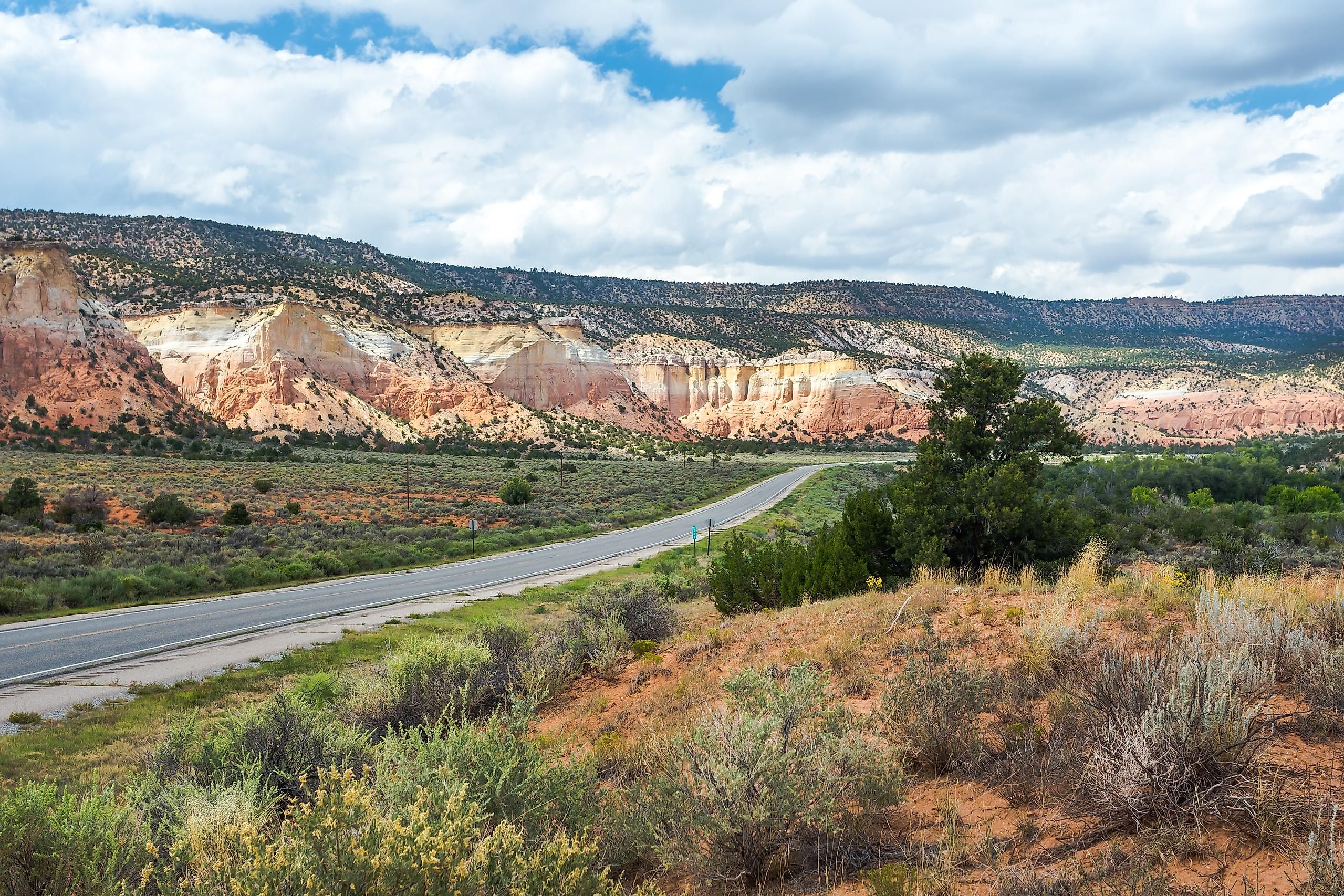
Trail Of The Ancient Scenic Byway

The ageless artifacts in broken and arid landscapes give way to the lands of the Ancient Puebloans. The trail is a 116-mile exploration with crucial pitstops like Mesa Verde National Park, which reflects an ancient town's remains, or the Ancients National Monument's Canyons, with the most archaeological sites in New Mexico.
The Trail of the Ancient Scenic Byway runs from southeastern Utah, southwestern Colorado, northeastern Arizona, and New Mexico, collectively called Four Corners. From Colarado's Mesa Verde National Park is roughly 68 miles to Aztec Ruins National Monument in northwestern New Mexico, where you will find the Great House built by Ancestral Puebloans, where you can go and explore the various rooms and passageways of mortar. Roughly 20 minutes from there is the Salmon Ruins in the south, an excavated village related to the Chaco Canyon.
The Chaco Cultural National Historical Park in the Chaco Canyon is our next destination, a world-renowned archeological site. Following the National Park's Service directions, you would be guided to an onsite campground. The state-designated scenic byway from Chaco Canyon goes towards Crownpoint, Grants, among other exciting locations. Some of the best archeological sites include the tribal land Trail of the Ancients, Monument Valley, Mesa Verde, and Chaco National Historical Park.
Salt Missions Trail

A fascinating adventure awaits as one embarks on the old trade routes of the Salt Missions from mountains to plains. As the road meanders through the ancient Pueblo villages filled with salt lakes and Manzano Mountains, it waves to you. It reminds you of yesteryears of salt collection and other minerals collected, traded, and transported on these beds. The abandoned Santa Fe Central Railroad is a must-see before heading your way to Tjeras. Tijeras Pueblo is a large masonry structure located at the northern end of the byway. Under the jurisdiction of Cibola National Forest, one can enjoy almost 80 rooms most days of the year. From Tijeras, one route of the Salt Missions runs east, going towards NM 333, which takes you to Moriarty. The byway from there runs to McIntosh and Estancia towards US Highway 60. The highway turns southwest towards Mountainair, where the western route of the Salt Missions Trail comes in, leaving the Tijeras. This stretch is filled with mountains and woods. The Abo ruins are close to the Mountain, roughly 9 miles away, while the Pueblo at Gran Quivira is on the south of Mountainair through NM 55. The Salt Missions Trail offers a unique experience to enjoy the vast salt beds while enjoying the breathtaking landscape that surrounds the salt beds.
New Mexico combines history, culture, and geography for a perfect vacation. The best way to enjoy the sights of this magnificent state is a fun road trip with your friends, as it gives you access to the wild wonders and scenic voyages that one might miss if one takes another form of transportation. On the map, New Mexico might remind you of a barren, dry land, but we guarantee it is much more than that, filled with exotic flora and fauna embraced in breathtaking landscapes with rivers and mountains of gems and salts. A magical desert where ancient civilization meets the modern world through well-connected roads.