11 Most Scenic Drives in Michigan
Michigan is made for scenic drives, with Lake Superior shorelines and forest roads that change dramatically with the seasons. If waterfalls are your idea of a memorable road trip, the Black River Scenic Byway stands out for its string of named falls, including Potawatomi, Gorge, Sandstone, and Rainbow Falls, all packed into just 15 miles. For a drive with one especially iconic stop, the Old Mission Peninsula Scenic Drive is worth the trip for Mission Point Lighthouse, which gives the route a clear destination at the peninsula’s northern tip. No matter which route you choose, these drives show just how much scenery Michigan can pack into a single road trip.
Black River Scenic Byway

Located in Gogebic County, the Black River Scenic Byway is a 15-mile byway tracing the Black River, with multiple stunning waterfalls dotting the route. The scenic byway begins at County Road 204, about four miles north of Bessemer, and follows County Road 513, with access to the North Country National Scenic Trail, a long-distance route popular with backcountry hikers.
Beginning in Bessemer, follow Black River Road along the river, where you can see forested areas and begin to pick out the many waterfalls in the area. First, you will spot the Great Conglomerate Falls, followed by the Potawatomy and Gorge Falls, which feature scenic outlooks and picnic areas. Continuing along the byway, you will find the Sandstone Falls, followed by Rainbow Falls and the nearby Rainbow Falls Trailhead. Continuing north, you will reach the final stop on the byway: Black River Harbor, where the river meets Lake Superior just north of the historic Black River Harbor Suspension Bridge.
Brockway Mountain Drive

The Brockway Mountain Drive is a 9-mile scenic drive in Michigan’s Keweenaw Peninsula running between Eagle Harbor and Copper Harbor. The two-way road on Brockway Mountain is among the highest-elevation drives in the region. The mountainside is enshrouded in trees and shrubbery, offering picturesque views from many scenic overlooks, especially in autumn, when the fields are awash in reds, golds, and oranges. Between the hiking and biking trails and the wildlife sanctuary on the mountain’s peak, there is plenty to do and see along this short drive.
Starting in Eagle Harbor, continue on M-26 toward the signed Brockway Mountain Drive entrance. From there, follow the scenic road up Brockway Mountain, where overlooks and pull-offs offer wide views toward Copper Harbor, Lake Superior, and the surrounding hills before the road descends near Copper Harbor.
Old Mission Peninsula Scenic Drive

The Old Mission Peninsula Scenic Drive is a 17.26-mile route running from Traverse City to the northern-most point of the township of Old Mission on Highway M-37. Along the route, you can enjoy the views of lush farmlands, the Grand Traverse Bay, the shores of Lake Michigan, and bluffs that can reach up to 200 feet, making for a diverse landscape in one short drive.
Starting in Traverse City, head north on Highway M-37 toward the peninsula’s orchards, vineyards, and bay views. The highway passes through Pelizzari Natural Area, offering views of forested areas and hiking and biking trails for travellers. Continuing along the M-37, you can see multiple vineyards along the roadside, including Mari Vineyards and Bonobo Winery. The road continues north to Old Mission, where you can stop at the Old Mission State Park before reaching the northernmost point of the route: the historic Mission Point Lighthouse.
M-22 Scenic Drive

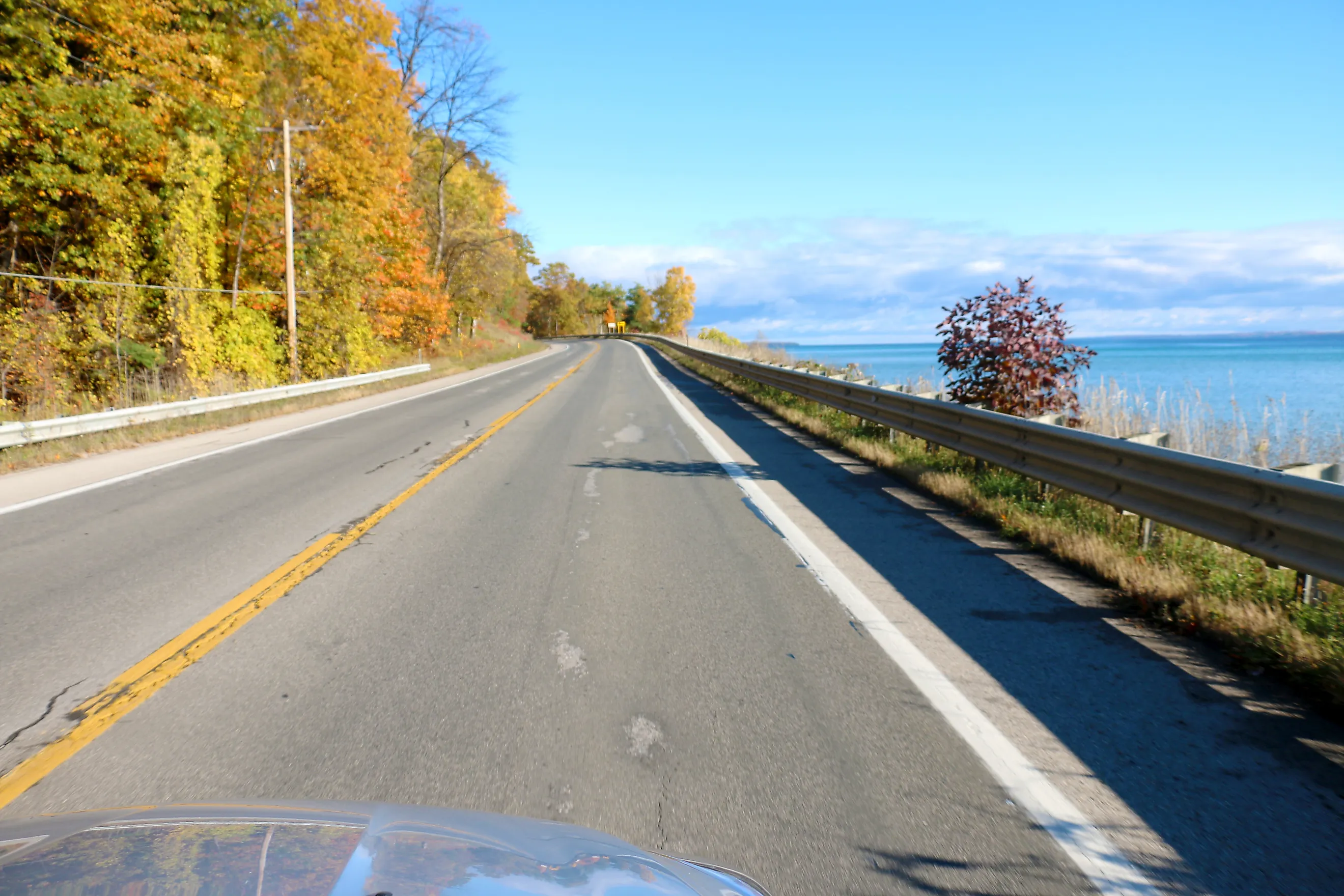
A 116-mile drive along the Lake Michigan shoreline, the M-22 Scenic Drive passes through Manistee, Benzie, Leelanau, and Grand Traverse counties with a mix of dunes, overlooks, and lakeside stretches. With trillium fields blooming in the Spring, Summer recreational activities on the lake, and the stunning colors of autumn, this trip has plenty of opportunities for year-round enjoyment.
Starting in Manistee, head north towards Arcadia, where you can enjoy views of the lake and surrounding trees on the boardwalk path at Inspiration Point before continuing to the Arcadia Dunes in the C.S. Mott Nature Preserve, with its hiking trails and outlook points offering stunning views. The route continues north, curving along the lake’s edge towards the Sleeping Bear Dunes National Lakeshore, a protected national lakeshore with towering dunes along the coast of Lake Michigan. The scenic drive continues along Highway M-22 with vineyards and scenic overlooks dotting the path before reaching its endpoint at Traverse City.
Tunnel of Trees

A 20-mile stretch on Highway M-119, the Tunnel of Trees is aptly named after the trees that line each side of the winding road, creating a “tunnel” effect. The route starts in Harbor Springs, stretching north along Lake Michigan to Cross Village. The trees offer stunning views year-round, but are especially striking in the autumn, when the leaves paint the path in vibrant colors. The Tunnel of Trees is a narrow two-lane road that can be difficult to navigate in larger vehicles.
Starting at Harbor Springs, take Highway M-119 north past Thorne Swift Nature Preserve and Hoogland Family Nature Preserve, where short stops offer wooded trails, shoreline access, and scenic overlooks. Continuing north towards the end of the route is the Woollam Family Nature Preserve, just outside of Cross Village, with wooded land and sandy dunes by the beach, with access to the lake.
Tahquamenon Scenic Byway

The Tahquamenon Scenic Byway is a 63-mile journey along Highway M-123 flanked by forests and views of the iconic Tahquamenon Falls, and the shoreline of Lake Superior. With its wild, forested land, waterfalls, and even opportunities to see the Northern Lights, this drive is one of the best in Michigan's Upper Peninsula.
The byway runs along M-123 between the two M-28 junctions, passing through Paradise. Along the route, you can stop at Tahquamenon Falls State Park and the Tahquamenon Logging Museum for a closer look at the region’s waterfalls and logging history.
Copper Country Trail National Byway

A 47-mile journey down Highway US-41, which used to be the backbone of the country’s copper mining industry, is now a scenic drive through Michigan. The Copper Country Trail National Byway runs from the Portage Lake Lift Bridge to Copper Harbor, with optional side routes down Highway M-203 and Highway M-26.
Starting at the lift bridge, travel north along the route where you can see the Quincy Mine in Hancock. Continuing along the route, you can find the Boston Pond in Laurium, a nature area with a pavilion and walking trail perfect for a peaceful excursion. Continuing along the highway, you will find the town of Mohawk, where you can take a tour of the historic Delaware Copper Mine. Between Delaware and Copper Harbor is the “Covered Road”, a portion of the byway surrounded by trees, with some standing mere feet from the road, offering stunning views.
River Road National Scenic Byway

A 22-mile drive along the Au Sable River Valley, the River Road National Scenic Byway is a scenic drive with plenty of opportunities for year-round enjoyment. Surrounded by the Huron-Manistee National Forest, the autumn colors shine through the valley for breathtaking views as you drive by, while the high bluffs offer plenty of winter sports opportunities. With the river and forested areas, there are plenty of hiking trails, or places to stop and watch the birds in the spring and summer months.
The byway begins around seven miles northeast of Hale, at the intersection of Highway M-65 and Rollway Road. You can enjoy the views from the Westgate Welcome Center and Overlook before heading east on highway M-65 towards the Iargo Springs Interpretive Site for a panoramic view of the Au Sable River and educational opportunities about the area's geology and local wildlife. Continuing east, you can stop at Foote Site Park for overlooks and river access. Continuing along the route towards the end point in Oscoda, with potential stops to enjoy the Eagle Run Trails, or Whirlpool River access.
Whitefish Bay National Forest Scenic Byway

The Whitefish Bay National Forest Scenic Byway is a 27-mile two-lane road along Lake Superior in Michigan’s Upper Peninsula. Starting where Lakeshore Drive begins, and running all the way to the intersection with Highway M-123 just outside of Paradise, Michigan, this byway runs parallel to the North Country National Scenic Trail, allowing you to enjoy the sites on foot and in the comfort of your vehicle. With part of the byway running through the Hiawatha National Forest, this drive offers the perfect balance of forest scenery and lakeside driving.
Starting near Brimley, follow the Whitefish Bay Scenic Byway west along Lake Superior. The route passes overlooks, picnic areas, and Point Iroquois Lighthouse before continuing through forested stretches and ending at the intersection with M-123.
Lake Superior Circle Tour

The Lake Superior Circle Tour is a loop around the world’s largest freshwater lake. Often done as a loop beginning and ending in Sault Ste. Marie in Michigan, the route spans 1,300 miles. The full route runs through Michigan’s Upper Peninsula, Northern Wisconsin, Eastern Minnesota, and Southern Ontario, Canada, making this one of the longest scenic drives in the state.
Starting in Sault Ste. Marie, the Michigan portion of the route heads west across the Upper Peninsula toward Wisconsin, with a substantial stretch following M-28. In many spots, the road hugs the shoreline of Lake Superior, with views of Tahquamenon Falls State Park and Wagner State Park along the way. Along the Michigan portion of the tour, you can visit Ontonagon and Porcupine Mountains Wilderness State Park, while Copper Harbor and F.J. McLain State Park make a separate Keweenaw side trip.
Hidden Coast Recreational Heritage Trail

The Hidden Coast Recreational Heritage Trail is a 62-mile route running along the Lake Michigan shoreline from Menominee northward. With much of the trail travelling along the Escanaba River State Forest, there are plenty of astounding views and opportunities for recreational activities for your trip.
Starting in Menominee, take Highway M-35 north. In Menominee, you can visit the Great Lakes Memorial Marina Park to enjoy access to the lake, or visit the Menominee County Historical Museum before continuing along the Byway. The route continues north, snaking along the lake until the highway meets forest land, where you can see the Escanaba River State Forest, with over 25 scenic overlooks to stop and enjoy views of the trees before continuing through the forest towards Gladstone.
The Best Scenic Drives in Michigan
Between the roads enshrouded in trees and the lanes snaking along rivers and lakeshore, Michigan offers some unique driving opportunities. Some routes follow the edge of Lake Superior, while others wind past inland forests, waterfalls, vineyards, and dunes. Taken together, these drives highlight the range of scenery that makes a road trip through Michigan worth taking.