7 Most Scenic Drives in The Prairies
Seven scenic byways across the central and northern Plains deliver a different kind of road trip than the mountain or coast routes get credit for. Distances out here are deceptive: towns sit further apart than the map suggests, gas stations close before sunset in many counties, and cell service drops out across long sections of the Sandhills, the Native American Scenic Byway, and the Outlaw Trail. Each of the routes below covers a distinct landscape: surviving tallgrass prairie, the largest grass-stabilized dune field in the Western Hemisphere, the Missouri River bluffs across four reservations, and a 525-million-year-old granite range rising out of the southern Plains floor. None requires a four-wheel drive. All reward driving with a half tank in reserve.
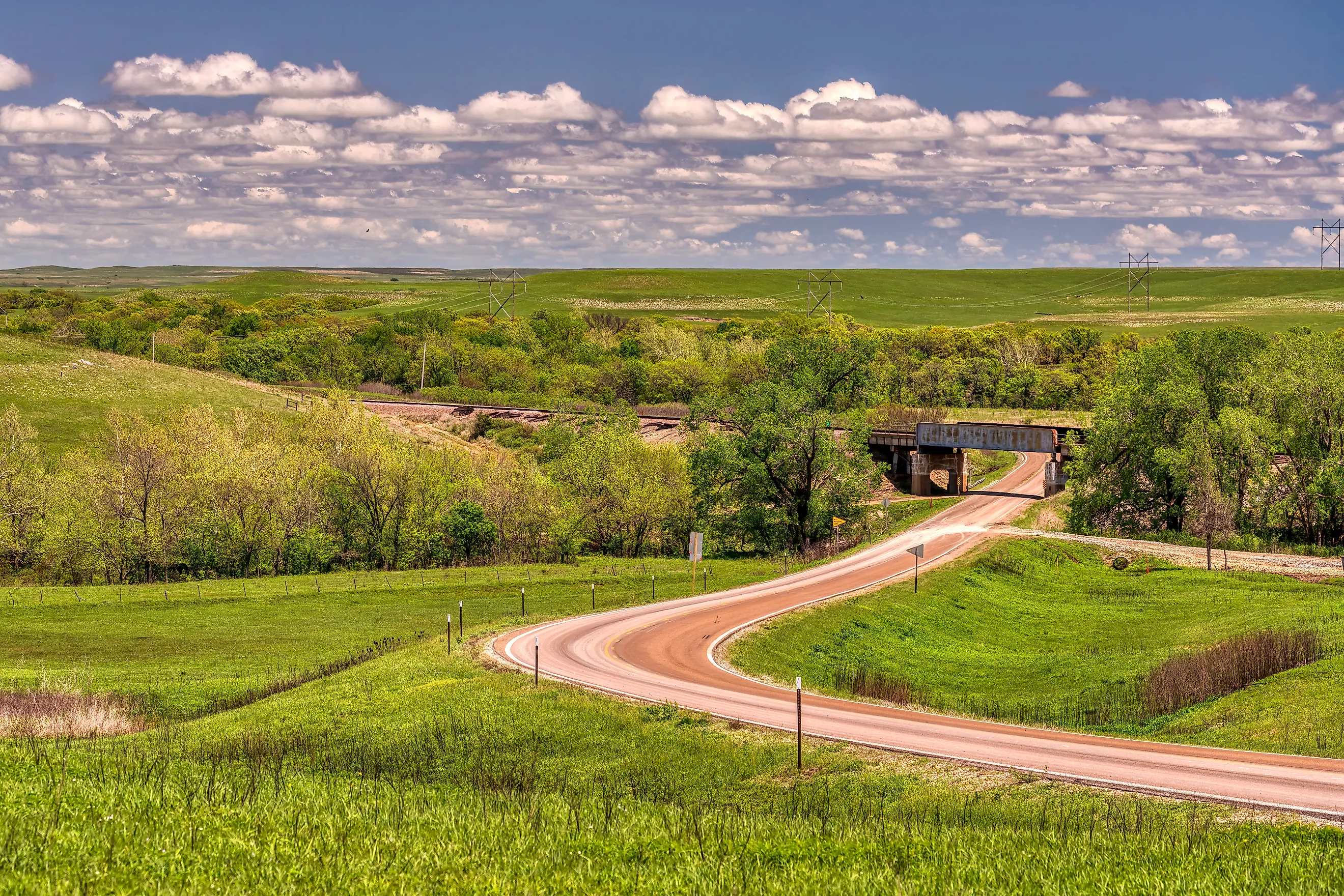
Flint Hills National Scenic Byway

Kansas Highway 177 covers 47.2 miles between Council Grove and Cassoday, threading through Morris, Chase, and Butler counties across what remains of North America's tallgrass prairie. Less than 4 percent of the original 170-million-acre tallgrass biome survives anywhere on the continent, and the Flint Hills hold one of the largest remaining stretches. Council Grove anchors the north end as an old Santa Fe Trail town with more than two dozen historic sites including the Kaw Mission and the Hays House, which has served meals continuously since 1857.
South of town, the road rolls through Strong City and Cottonwood Falls, where the 1873 Chase County Courthouse on Broadway Street is the oldest operating courthouse in the state. Three miles further south, the Schrumpf Hill Scenic Overlook is the only purpose-built pull-off on the route. Interpretive signs there explain the geology of the underlying limestone and chert, and the panorama opens across miles of open ranchland. The Tallgrass Prairie National Preserve sits east of the road just north of Strong City. The two-lane pavement runs clean from end to end, and the drive itself takes about 55 minutes without stops, though most travelers take longer with a few roadside stops.
Sandhills Journey Scenic Byway

From Grand Island to Alliance, Nebraska Highway 2 covers 272 miles through the Sandhills, a 19,300-square-mile region of grass-stabilized dunes that ranks as the largest such formation in the Western Hemisphere. The byway designation runs the full stretch and crosses the heart of cattle country. Ranches out here are measured in sections rather than acres, and the human population averages well under one person per square mile across most counties along the route. Northwest of Grand Island, the road follows the Middle Loup River through Broken Bow and Thedford, then climbs onto the dunes where grass-covered hills roll out to the horizon in every direction. Nebraska National Forest sits along the route near Thedford as one of the largest hand-planted forests anywhere in the country.
The town of Mullen marks roughly the midpoint and serves as the practical fuel and food stop. Gas stations are thinly spread out here, and many close before sunset. Past Mullen, the road continues through Hyannis and Bingham before terminating in Alliance, where Carhenge, the auto-body recreation of Stonehenge, has become the route's most photographed roadside stop. The pavement runs flat throughout. Summer through early fall delivers the region's strongest light and the green-gold grass color, while winter driving brings blowing snow that can drift across the road quickly with little warning.
Native American Scenic Byway

The Native American Scenic Byway uses segments of South Dakota Highways 1804, 1806, 34, 37, 50, and 63, tracing the Missouri River past the Standing Rock, Cheyenne River, Lower Brule, and Crow Creek Reservations. The route follows Lewis and Clark's path up the river and counts as one of the few scenic byways in the country that crosses tribal lands for most of its length.
Highway 1806 runs along the west bank between Mobridge and Chamberlain. Highway 1804 covers the east bank, and bridges link the two at intervals. The bluffs above Lake Oahe and Lake Sharpe rise high enough to give long views across the impounded river, and the Sitting Bull Monument near Mobridge marks the gravesite of the Hunkpapa Lakota leader. Eagle Butte serves as the seat of the Cheyenne River Sioux Tribe and is home to the H.V. Johnston Lakota Cultural Center. The road stays paved throughout in two-lane sections that see modest traffic, and winter weather makes late spring through early fall the most reliable driving window.
Enchanted Highway

A 32-mile county road runs south from Interstate 94 at the Gladstone exit to the small town of Regent, in southwestern North Dakota. The route is the work of one man. Gary Greff, a former school principal from Regent, started building large-scale scrap-metal sculptures along the road in 1989 to draw visitors into a town that had lost most of its population. Seven sculptures stand along the route at present. The most famous is "Geese in Flight" near the Gladstone end, which the Guinness Book of World Records recognized as the world's largest scrap-metal sculpture at 110 feet tall and 154 feet wide. The other installations have names like "Deer Crossing," "Grasshoppers in the Field," and "Pheasants on the Prairie," along with "Fisherman's Dream," "Teddy Rides Again," and "Tin Family" further south. Each sculpture has its own pull-off and interpretive sign.
The county road itself is paved but narrow, with no real shoulders, and the surrounding country is open prairie ranchland with almost no built structures between the sculptures. Regent at the southern end has limited food options. The drive takes about 45 minutes one way without stops, and most visitors loop back to I-94 the way they came in, using the sculpture pull-offs as their natural breaks.
Sheyenne River Valley National Scenic Byway

Sixty-three miles of pavement trace the Sheyenne River through southeastern North Dakota between Baldhill Dam at the north end and Lisbon at the south. The route uses State Highways 27 and 32 along with several connecting county roads, following the river through one of the few genuine valleys in the eastern half of the state, where wooded bluffs rise above the surrounding plains. Fort Ransom State Park sits roughly midway and includes the restored 1880s Sunne Farm, a Norwegian-American homestead with original outbuildings preserved on site.
The town of Fort Ransom holds a small grid of preserved buildings and runs an annual sodbuster festival. Farther north, a short stop near Nome leads to Standing Rock State Historic Site, where four interconnected Native American burial mounds and the Íyá Bósdata/Standing Rock landmark overlook the Sheyenne River. Baldhill Dam at the north end impounds Lake Ashtabula and offers a viewpoint over the valley below. The road runs paved throughout with a few rolling grades that present no challenge to a standard vehicle, and the autumn color along the river bluffs from late September through mid-October makes this one of the state's strongest fall drives.
Outlaw Trail Scenic Byway

Nebraska Highway 12 covers roughly 231 miles along the northern edge of the state, from the Missouri River near South Sioux City west to Niobrara River country and on toward Valentine. The byway takes its name from the late-19th-century outlaw and rustler activity in the region. The route traces the Niobrara River for much of its length through one of the most ecologically distinctive corridors in the central Plains. The river itself carries a federal National Scenic River designation, and a 76-mile stretch passes through six different ecosystems where eastern hardwood forest, northern boreal forest, and Sandhills grassland all meet within a few miles of each other. Smith Falls State Park, along the river, contains the tallest waterfall in Nebraska at 63 feet.
The town of Valentine serves as the main service stop and is the gateway to Fort Niobrara National Wildlife Refuge, where bison and elk roam along the road on the east side of town five miles from the highway. The byway runs paved end to end and handles standard traffic year-round, though winter brings the same blowing-snow hazards as the Sandhills route to the south, which can change conditions quickly.
Wichita Mountains Scenic Byway

The Wichita Mountains Scenic Byway forms a loop on Highways 49, 58, 115, and 19 through and around the Wichita Mountains Wildlife Refuge, with Medicine Park as the most natural starting point. The Wichita Mountains rise abruptly out of the southern Plains as a 65-mile-long range of granite domes and outcroppings. Geologists date them to roughly 525 million years ago, making them among the oldest exposed rock formations in North America. The wildlife refuge itself covers 59,020 acres and supports a free-ranging herd of approximately 650 American bison, along with elk, longhorn cattle, and prairie dogs that visitors can usually spot from the road.
Mount Scott summit road branches north off Highway 49 and climbs to the 2,464-foot summit with panoramic views across the prairie below. Doris Campground and Lake Quanah Parker sit along the route as natural breaks. Medicine Park at the eastern end is a 1908 cobblestone resort town now restored as a small artist colony. The road through the refuge stays paved and gently graded, suitable for any vehicle, though Mount Scott's summit road requires attention on its switchbacks, especially in poor weather.
Practical Notes for Plains Driving
Distances on the Plains can fool first-time drivers. Towns sit further apart than highway maps suggest, gas stations close earlier than urban drivers expect, and cell service drops out across long stretches of the Sandhills, the Native American Scenic Byway, and the Outlaw Trail. The standard advice for any of these routes is to fill up at half a tank rather than wait for the next station, and to download maps for offline use before heading out. Late spring through early fall remains the most reliable season across all seven routes, with the late-September through mid-October window combining mild weather with the strongest prairie color. Winter driving brings sudden ground blizzards that can drop visibility to zero within minutes, and any of these routes can become impassable on short notice between November and March.