8 Tiny Off-Grid Towns In New South Wales
New South Wales' off-grid towns grew from practical origins in farming, mining, and small-scale industry. Many stayed modest in size as development shifted toward larger regional hubs, preserving the scale and layout that first shaped them.
That history still influences these towns today. They sit within reach of national parks that protect the Gondwana rainforest, river systems such as the Darling River, one of Australia's longest, and historic sites like the Old Butter Factory Café. Services are usually limited to the essentials. Anything more means driving inland roads to the next town.
Nimbin

Street View of Nimbin, New South Wales.
Nimbin is a remote village with alternative communities and limited commercial development surrounded by rainforest. Its isolation helped keep large-scale development away. Set near the Nightcap Range, Nimbin is about 19.2 miles (31 km) from Lismore, the nearest regional center. After the local dairy industry declined in the mid-20th century, the town never became a major service hub. Instead, the 1973 Aquarius Festival helped redirect the town toward communal living, small-scale farming, and independent local trade.
Nightcap National Park borders the village and protects one of Australia’s largest areas of subtropical Gondwana rainforest. Nearby, Minyon Falls drops 328 feet (100 m), with views reached by an 8-mile (13 km) return track. Protesters Falls is tied to a 1979 anti-logging blockade that helped protect the rainforest. The 11-mile (18 km) Historic Nightcap Track follows ridgelines through remote sections of the park.
Bellingen

Bellingen lies in a narrow river valley, where its historic streetscape, small-scale local trade, and close connection to the rainforest have remained largely intact. The Dorrigo Plateau separates the town from coastal growth around Coffs Harbour, 21.4 miles (34.4 km) away. After the timber and dairy industries slowed in the mid-20th century, Bellingen never developed into a larger service hub, retaining its quieter, more local character.
Federation-era buildings still line the town center, and the historic Old Butter Factory Café continues to operate nearby. The monthly Bellingen Community Markets continue to drive local trade. All traffic moves through regional roads along the Bellinger corridor, with no direct rail link into the valley. Above the valley, Dorrigo National Park protects the Gondwana rainforest. The 4.1-mile (6.6 km) Wonga Walk passes through dense forest canopy and leads to Crystal Shower Falls and Tristania Falls.
Carinda

Carinda Hotel at Carinda, New South Wales. Editorial credit: Wikimedia Commons
This remote outback settlement was shaped by the wool industry and the surrounding semi-arid plains. Its isolation has kept development limited and large-scale growth away. Along the Castlereagh River in far north-western New South Wales, Carinda is about 43.2 miles (70 km) from Walgett, the nearest service town. After the early 20th-century wool peak declined, the town never became a service hub. Instead, the 1983 filming of the 'Let's Dance' music video at the Carinda Hotel connected it to a rare moment of international exposure.
The Castlereagh River flows intermittently through the area, allowing grazing across the plains. To the southeast, the Macquarie Marshes form one of Australia’s largest freshwater wetland systems, where semi-permanent lagoons support waterbird populations during flood cycles. Beyond the hotel and grain silos, unsealed roads stretch across flat country with minimal infrastructure.
Coonabarabran

Coonabarabran is a central-western town that developed around pastoral services before becoming known for its dark skies. This gave the town a scientific identity rather than a large commercial profile. The Newell Highway carries most traffic into town, and the original rail line is no longer in use. Dubbo, the nearest regional center, is 89 miles (143 km) south.
Siding Spring Observatory stands 3,822 feet (1,165 m) above sea level on Mount Woorat in Warrumbungle National Park. It is home to the 12.8-foot (3.9 m) Anglo-Australian Telescope. The national park also holds Australia's first Dark Sky Park designation and protects the remnants of an ancient shield volcano. The Breadknife, a narrow lava dyke, rises 295 feet (90 m) from the valley floor. Milroy Observatory runs guided night sessions led by Donna, a research astronomer with experience at Siding Spring.
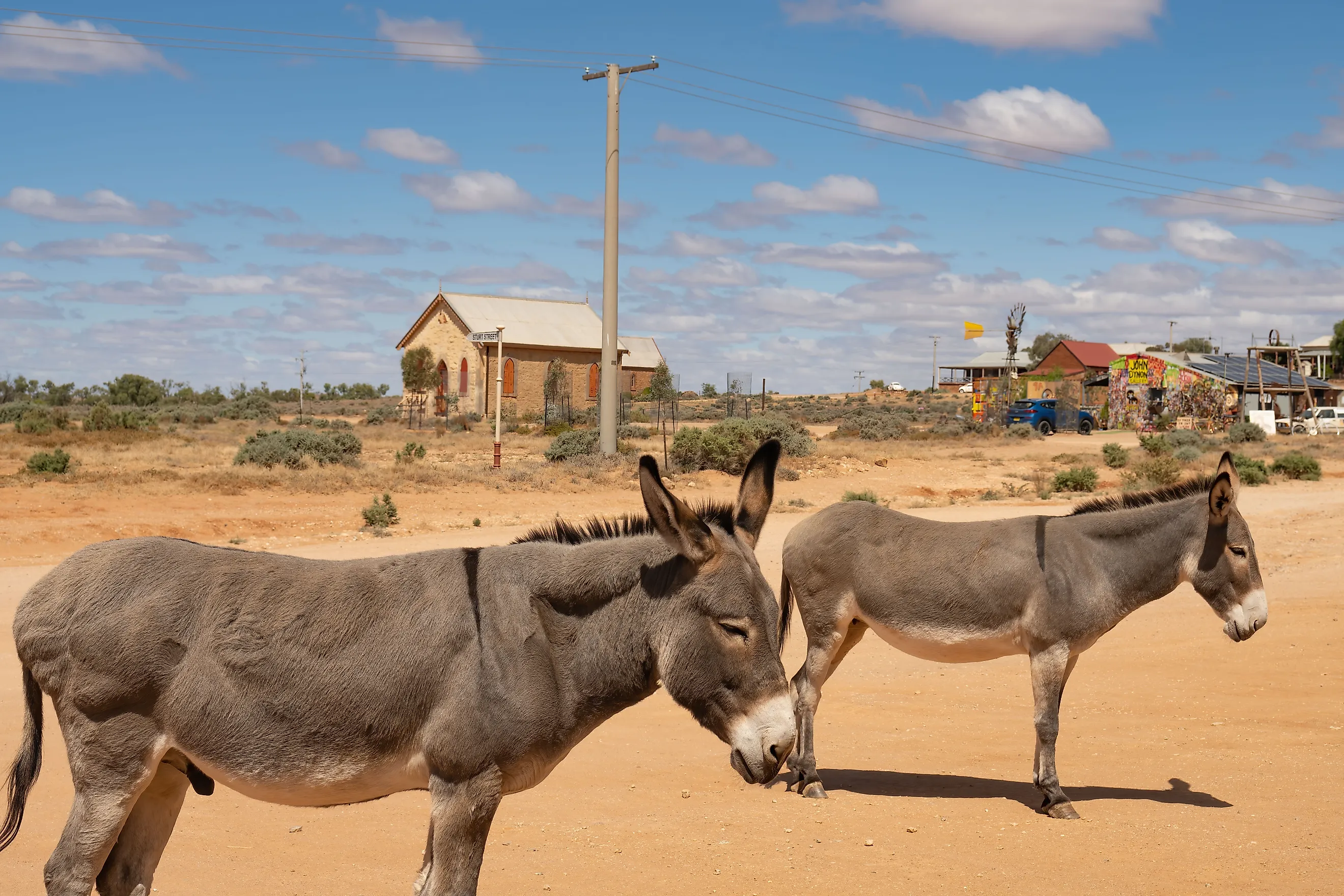
Silverton

The historic Silverton Hotel in Silverton, New South Wales, Australia.
Silverton is a remote desert settlement known for silver mining and its harsh terrain. Red dust, dry conditions, and open desert limited its growth from the start. Mining brought a brief boom in the late 19th century, but when the industry declined, most residents moved on.
Today, a single sealed road links the town to Broken Hill, the nearest service center, about 16 miles (25 km) away. Because Silverton never spread far beyond its original footprint, several historic stone buildings still stand. The Silverton Gaol Museum occupies a former lockup and displays objects from the mining era. The Silverton Hotel is one of the town’s best-known landmarks. Just outside town, Mundi Mundi Lookout opens onto the vast Mundi Mundi Plains, a flat expanse stretching toward the South Australian border.
Lilyvale

Lilyvale NSW, Australia. Editorial credit: Wikimedia Commons
Lilyvale is a coastal locality that grew around rail access and parkland use but never developed into a residential or commercial center. Dense forest, steep cliffs, and protected land kept large-scale development away. The heritage-listed Illawarra railway line and Princes Highway pass through, but there is no active station. Sydney, the nearest major center, is about 40 miles (64 km) north.
The landscape keeps the area isolated. Lilyvale forms part of the Garawarra State Conservation Area and borders Royal National Park along the Pacific coast. Coastal tracks lead to Fraser's Point, where cliffs drop directly to the ocean. A rock platform walk leads to the Figure Eight Pools near Burning Palms Beach. The Palm Jungle loop track passes through dense subtropical vegetation and sheltered rainforest gullies.
Menindee

Menindee is a remote town along the Darling River, where a chain of lakes stores and controls water across an otherwise dry landscape. River trade first drew settlement, but that role declined as transport shifted elsewhere. In the mid-20th century, engineers converted shallow floodplain basins into the Menindee Lakes system, one of the largest inland water storage networks in Australia.
The lakes hold up to 457 billion gallons (1,731 gigalitres). They supply water to Broken Hill, about 70 miles (112 km) west, and regulate flow through the lower Darling.
The lakes spread across the floodplain and expand during high inflows, drawing large numbers of waterbirds. Ibis, pelicans, and herons gather here in numbers rarely seen in arid Australia, giving the area Important Bird Area status. Kinchega National Park follows the river through former pastoral land. Its 19th-century woolshed points to the area’s grazing history, and river red gum forests show the influence of seasonal floods.
Lightning Ridge

Lightning Ridge grew around black opal mining, and the culture that followed has kept it one of the most eccentric and isolated towns in New South Wales. Miners staked claims across the ridge before any formal plan existed, and dig sites pushed housing in irregular patterns. The town never developed into a regional service hub. Walgett, the nearest center, is 46 miles (74 km) away, connected by a single sealed road.
The town sits above the Great Artesian Basin, where naturally heated groundwater rises through the bore baths and fills the pools with mineral-rich water. Black opal fields extend across the surrounding land, with active shafts and abandoned workings. The Chambers of the Black Hand preserves underground carvings cut into sandstone over several decades. Car Door Tours follow rough tracks through the mining fields, where painted car doors mark the route.
Where the Grid Ends and the Story Begins
These towns began with farming, mining, river trade, or small local industries. When those roles declined, growth shifted toward larger regional centers. As a result, these places kept their original scale. Terrain and location limited growth, and influenced how these towns function. Long distances and limited services mean most residents drive to the next town for anything beyond basic needs. Across remote parts of New South Wales, those early conditions still hold.