The Deepest Canyon In Any National Park
Hidden under a river of ice in Alaska's Denali National Park and Preserve is a chasm that almost no one has ever seen the bottom of. The Great Gorge of the Ruth Glacier runs deeper than the Grand Canyon, yet most of its depth is buried beneath thousands of feet of glacial ice. Granite walls climb roughly 5,000 feet straight off the surface of the glacier, and the true floor sits far below that. Recent radar measurements suggest the full gorge approaches 8,000 feet, rim to bedrock. Here is why what may be the deepest gorge in North America is one you cannot look down into, and how it stacks up against the country's other deep national park canyons.
A Gorge Buried in Ice

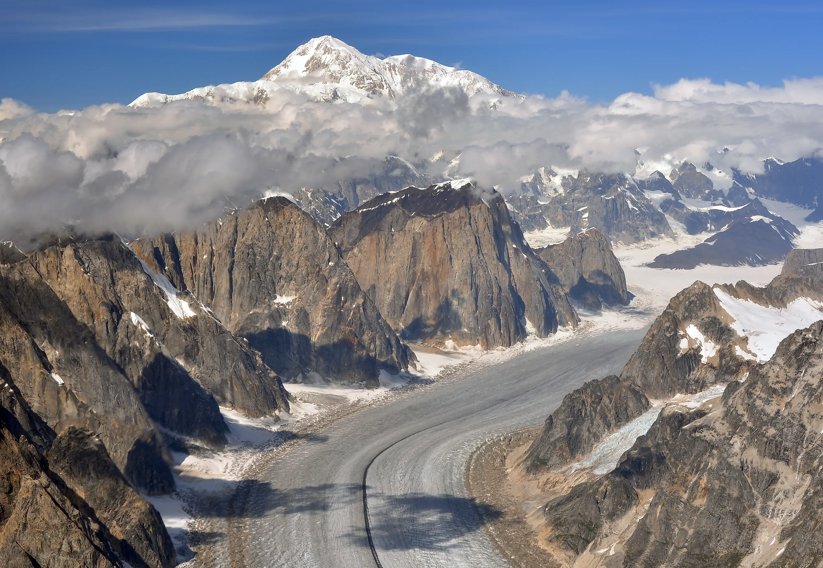
The Ruth Glacier drains the southeastern flank of Denali, funneling every flake of snow that falls on that side of the mountain into a corridor barely a mile wide. Where the ice squeezes through that granite-walled slot, mountaineers call it the Great Gorge. The Ruth Glacier stretches about 40 miles in all, and the gorge itself runs for roughly 10 of those miles.
What makes the gorge extraordinary is that the ice fills it like water in a bathtub. The glacier is nearly 3,800 feet thick at this point, some of it more than a thousand years old. So when you stand on the surface and look up at walls rising 5,000 feet on either side, you are seeing only the top half of the story. The rock keeps going down beneath your feet, hidden under all that ice.
Peaks with names like the Moose's Tooth, the Bear's Tooth, and the Eye Tooth line the rim, sharp granite spires that give the range its bite. Mount Dickey, on the gorge's western wall, is often called the tallest granite wall in North America when its ice-buried lower portion is counted. These walls draw expert climbers from around the world, since the rock stands nearly vertical straight off the glacier.
How Deep Is It, Really

Measuring a gorge you cannot see the bottom of is a genuine problem. Explorer Bradford Washburn first flew over the Great Gorge in 1937 and suspected it was exceptionally deep, but proving it took decades. A 1992 survey by scientists from the University of Alaska Fairbanks put the figure at nearly 9,000 feet from the rim to the buried bedrock floor, deeper than the steepest sections of both the Grand Canyon and Yosemite.
That number stood for years, but glaciologists kept refining it. A 2024 study combined ice-penetrating radar with a mass-conservation model to map the rock floor beneath the ice, and it estimated the gorge at about 8,085 feet. The exact figure shifts with the method, which is exactly the trouble with a gorge that is mostly ice. The measurement has to account for roughly 3,770 feet of glacier sitting on top of the true floor.
Strip the ice away entirely, as those surveys did on paper, and the walls would rise close to 8,000 feet from bedrock. That would make the Great Gorge one of the deepest defiles on the continent, cut by the same combination of tectonic uplift and relentless glacial grinding that shaped the rest of the Alaska Range.
Ice, Granite, and the Making of the Gorge

The gorge exists because two forces have been working against each other for millions of years. The whole Alaska Range is still rising, squeezed upward along the Denali Fault, a crack in the crust that runs nearly 1,200 miles across the state. Where the fault bends near Denali, rock stacks against rock and the mountains push higher, lifting the peak itself by roughly half a millimeter a year even now. That uplift handed the ice something tall to carve.
The rock doing the standing is granite, a mass of it that cooled underground before being exhumed and lifted into the sky. Its strength is the reason the walls stay so sheer. Geologists studying the range have described these as "Teflon peaks," because the granite holds smooth, near-vertical faces that shed snow rather than holding it.
That shedding feeds the glaciers below. Snow avalanching off the steep walls piles onto the valley floor, thickening the ice that then grinds downward through the corridor. Over successive ice ages the Ruth Glacier deepened its trench faster than the peaks eroded, opening the vertical gap between summit and floor that makes the gorge so deep. The same process built the highest relief anywhere in North America, right here around Denali.
Reaching a Place Almost No One Sees

No road reaches the Great Gorge. The way in is a ski-equipped bush plane out of Talkeetna, about a 40-minute flight that threads the granite corridors before setting down on the glacier itself. That access is the legacy of one man, Don Sheldon, the pioneering bush pilot who first landed on the Ruth in the 1950s and grasped what the place could be.
Sheldon built a small cabin, now known as the Mountain House, on a rocky outcrop at about 5,800 feet in the Don Sheldon Amphitheater, the broad ice basin at the head of the glacier just above the gorge. It may be the most improbably sited cabin on the continent, ringed on every side by granite walls and ice pouring off Denali less than ten miles away. The only approach is still by plane, then a short hike up permanent stairs cut into the rock.
The gorge draws two kinds of visitors. Climbers come in the spring and summer for first ascents on the "Tooth" peaks and the great monoliths of the western wall, staging out of fly-in base camps. Everyone else comes for the view from the air, since the flightseeing runs out of Talkeetna trace the same corridor Sheldon flew, threading through the gorge and into the amphitheater with an optional landing on the ice.
How It Compares to the Deepest Park Canyons
Ranking the deepest canyons inside national parks is harder than it sounds, because a glacier-filled gorge and an exposed river canyon are not measured the same way. There is no official nationwide list. Using National Park Service figures, though, a handful stand clearly above the rest, and each earns its depth in a different way.

The Grand Canyon, in Arizona, is the benchmark. It reaches about 6,000 vertical feet of rim-to-river relief at its deepest point, near the North Rim, and averages roughly 4,000 feet across its 277-mile length. Unlike the Ruth Gorge, every foot of it is open to the sky, which is why it remains the canyon most people picture first.

Kern Canyon, deep in the backcountry of Sequoia National Park in California, carries roughly 5,000 feet of relief from the peaks down to the river along a continuously incised stretch of about 30 miles. It is one of the deepest canyons protected entirely within a national park boundary, though it takes a multi-day hike to reach.

Yosemite Valley rounds out the group at roughly 3,000 feet deep, though its story is written in ice rather than moving water alone. The Merced River began cutting this stretch of the Sierra Nevada tens of millions of years ago, and uplift about five million years ago steepened its descent. Then, starting around 2.5 million years ago, successive Ice Age glaciers ground down the canyon, plucking away weaker granite along natural joints and polishing the harder rock into the sheer faces visible today. El Capitan, the largest granite monolith on Earth, rises about 3,000 feet straight off the valley floor with barely a crack for climbers to follow. Half Dome towers even higher, close to 5,000 feet above the flat, sediment-filled floor that marks where a glacial lake once stood.

Zion Canyon in Utah sits close behind, its Navajo Sandstone walls climbing up to 2,640 feet above the North Fork of the Virgin River across a stretch of about 15 miles. The rock itself began as a vast field of desert dunes roughly 180 million years ago, later buried, cemented, and lifted with the rest of the Colorado Plateau. The river then cut down through it, exposing cliffs in bands of cream, pink, and red. Landmarks like the Great White Throne, rising nearly 2,500 feet, and the narrow fin of Angels Landing, standing close to 1,500 feet above the floor, give the canyon its scale. Unlike a rim-view canyon, most visitors experience Zion from the bottom looking up, walking the floor as the sandstone towers overhead.

Black Canyon of the Gunnison in Colorado follows at a precisely measured 2,722 feet, and it earns its depth through sheerness rather than sprawl. At its narrowest the gap between the rims closes to about 1,100 feet, and the canyon floor pinches to just 40 feet across at the river. The walls are so steep and close that parts of the floor receive little more than half an hour of direct sunlight a day, which is how the canyon got its name. The Gunnison River carved this over roughly two million years, cutting through some of the oldest and hardest rock on the continent, gneiss and schist nearly two billion years old shot through with pink pegmatite veins. Only about 14 miles of the 48-mile canyon lie inside the national park, but that stretch holds its deepest and steepest sections.
The Deepest Canyon You Cannot Peer Into
A common claim hands the deepest-canyon title to Kings Canyon in California, at roughly 8,000 feet. That measurement is real, but the National Park Service notes it is taken a few miles outside the Kings Canyon National Park boundary, so it does not cleanly top a strict list of park canyons. The Ruth Gorge carries no such asterisk: it lies squarely inside Denali National Park and Preserve.
What sets the Great Gorge apart is not just its depth but its disguise. The Grand Canyon overwhelms you with everything laid bare, layer on layer down to the river. The Ruth Gorge does the opposite. It hides its scale under a mile-wide ribbon of ice, so the deepest gorge on the continent looks, from above, like a smooth white highway winding between the peaks. The real drop is the part you never get to see.