Areas Disputed By The US And Canada
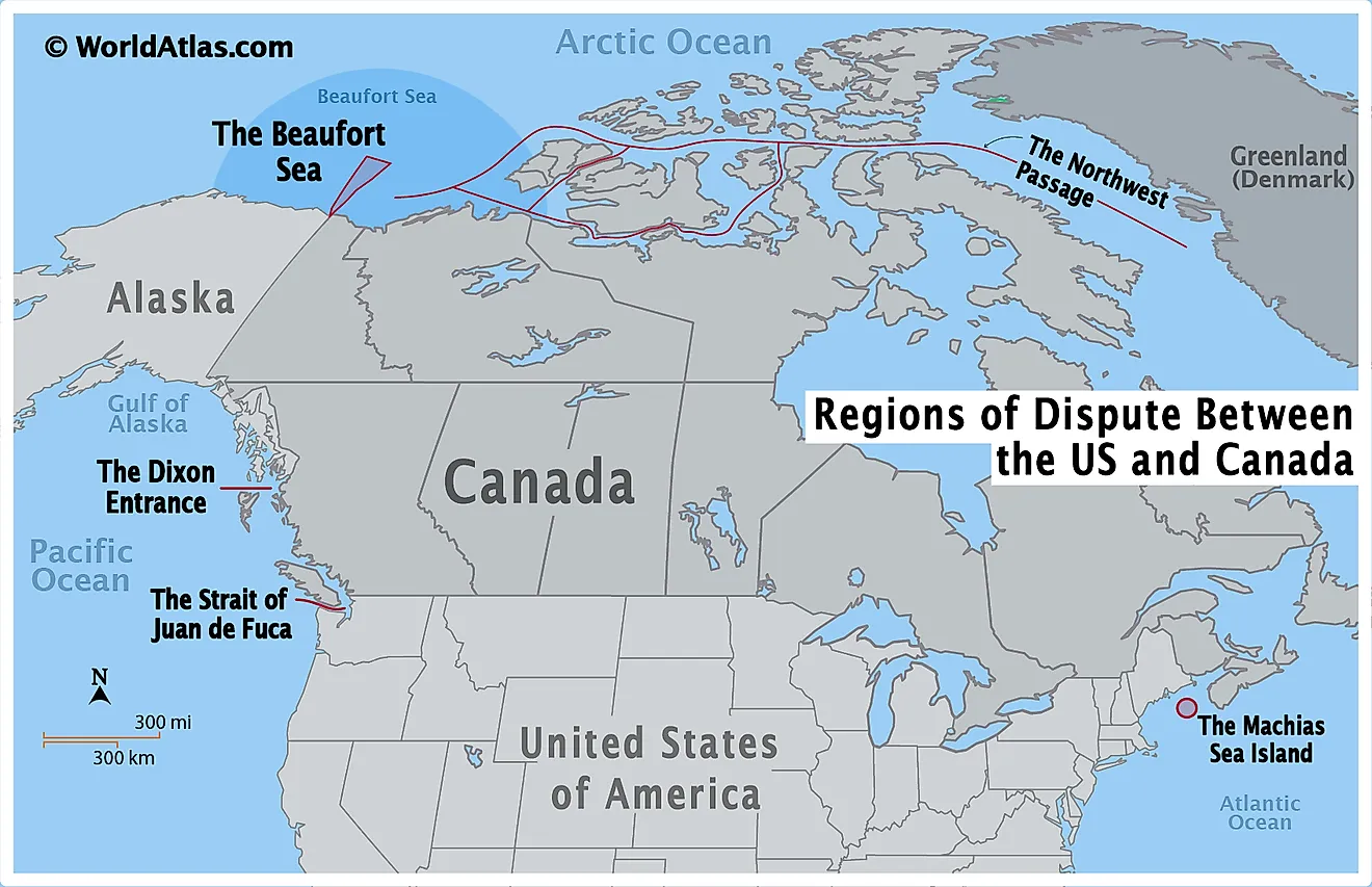
- The United States and Canada have maintained cordial relations for about a century, but some border disputes between the two countries still remain.
- The United States and Canada have a total of 5 ongoing border disputes.
- The border disputes between the United States and Canada all center around maritime claims.
Some call the border between the United States and Canada the world’s longest undefended border. There were times when relations between the two countries were frosty. In fact, the United States and Canada have even engaged in armed conflict with each other on some occasions. The days of conflict and even outright hostility between the two countries, however, are long gone. Indeed, the two neighbors have maintained a very cordial relationship with each other for the last century. Nevertheless, the United States and Canada still have their differences and disagreements. In fact, inasmuch as the border between the two countries is undefended, there are some disputes between the two countries as to where that border should be in some places. Today, Canada and the United States have 5 major ongoing border conflicts.
The Dixon Entrance

The Dixon Entrance is a 50-meter wide strait situated on the United States-Canada border, between the US state of Alaska and the Canadian province of British Columbia. The strait is named after George Dixon, who surveyed the area in 1787. Before the arrival of Europeans, the region was the subject of hostilities between local, indigenous peoples. The actual border dispute, however, dates back to the 18th century, when Britain and Russia were colonizing the area. The two empires did conclude a treaty in 1825, known as the Treaty of St. Petersburg, which established a border in what became the Alaska Panhandle, but because the area was largely unsurveyed, the agreement did not permanently put the issue of the border to rest. By the end of the 19th century, the United States was in control of Alaska, and neighboring British Columbia was a province of Canada. The discovery of gold in the area resurrected the Dixon Entrance border dispute.
In 1903, a Court of Arbitration was set up in order to establish a boundary between the United States and Canada in the Dixon Entrance. This court drew up a line, known as the A-B line, in the strait as part of the Alaska Boundary Treaty. But to this day, the United States and Canada dispute the meaning of this line. Canada considers the A-B line to be the international maritime border between the two countries in the area. The United States, however, disagrees, insisting that the line simply delineates the land masses of the area that belong to each country. In 1977, the United States drew up a maritime boundary in the area on its own. This line and the A-B line intersect to form four different areas, two in the north and two in the south. The two northern areas are claimed by both the United States and Canada, while the southern areas are unclaimed. One of the disputed northern areas is 2,789 sq. km, while the other is a much smaller 51.5 sq. km. This border dispute owes its present-day significance to the fact that the Dixon Entrance contains vast stocks of salmon, which are vital for both the Canadian and American fishing industry.
The Northwest Passage

The Northwest Passage is a sea route that connects the Atlantic Ocean in the east with the Pacific Ocean in the west, by way of the Arctic Ocean. The vast waterway is situated in the Canadian territories of Nunavut and the Northwest Territories. There is no dispute over the land in the region. What is in dispute, however, is the status of the waters contained in the Northwest Passage. Canada considers most of the waterway to be part of its territorial waters, particularly the waters that are situated in the Canadian Arctic Archipelago. The United States, however, considers it to be an international waterway, meaning that it should not fall under the exclusive jurisdiction of any country. The European Union supports the United States' stand on this matter.
The dispute over the Northwest Passage began because of an incident that occurred in 1969, when a US oil tanker passed through the waterway without the permission of Canadian authorities. In response to this incident, Canada passed legislation asserting its control over environmental regulations in the waterway. Another incident occurred in 1985, when the Canadian Coast Guard tried to inspect an American vessel, a move which infuriated the US government. Canada, however, was unapologetic, as it responded by issuing a declaration reaffirming its right to the Northwest Passage.
For its part, the United States claims that the Northwest Passage should be designated an international waterway in accordance with the United Nations’ Convention on the Law of the Sea, even though the United States never ratified this convention. Canada has countered by using legal arguments from cases that were resolved by the International Court of Justice. The Canadians have also cited the historic use of the Northwest Passage by the indigenous Inuit population to bolster their claims. The dispute is significant because the Northwest Passage can serve as a transit conduit between the Atlantic and Pacific Oceans, especially in the age of climate change, when melting sea has made the waterway more navigable.
The Beaufort Sea

The Beaufort Sea transcends the territorial waters of the United States and Canada. It is located north of the US state of Alaska and two Canadian territories, the Yukon Territory and the Northwest Territories. The border dispute between the United States and Canada is over where the international maritime border between the Yukon Territory and Alaska should be situated. As was the case with the Dixon Entrance, the border between Alaska and the Yukon was subject to the Treaty of St. Petersburg, which delineated the border between Russian and British territory at the time. According to the agreed-upon border arrangement, the international maritime border was to follow the land border that now divides Alaska and the Yukon, along the 141st meridian.
Today, Canada recognizes the 141st meridian as its border with the United States in the area. The Americans, however, argue that the border should be drawn halfway between the two countries from any point on land, equidistant from both countries’ coastlines. The overlap of the borders recognized by the United States and Canada form a small, pie-shaped slice of the Beaufort Sea, which is the area in dispute. This area encompasses about 13,035 sq. km.
At the forefront of the Beaufort Sea dispute is the presence of vast natural resources in the area. Although the sea is covered by ice most of the year, climate change has led to significant ice-melting. Thus, the Beaufort Sea and other parts of the Arctic Ocean are becoming more accessible than they ever were before the effects of climate change took hold. The Beaufort Sea is home to vast oil and gas reserves, as well as significant Arctic fishing stocks.
The Strait of Juan de Fuca

The Strait of Juan de Fuca connects the Salish Sea in the east to the Pacific Ocean in the west. It is approximately 154.5 km long, and is situated between Vancouver Island in Canada and Washington State in the United States. The international maritime boundary between the United States and Canada in the Strait of Juan de Fuca lies in the middle of the channel. There is no dispute over this border. What is in dispute, however, is the 320 km long seaward boundary that extends west out of the Strait of Juan de Fuca into the Pacific Ocean.
Both the Canadian and US governments have proposed that the boundary be drawn in accordance with the concept of equidistance. There is disagreement, however, on the basepoints from which the border would extend, thus leading to the creation of a disputed area where the lines from the two conflicting basepoints overlap. In addition, the Canadian province of British Columbia rejects the equidistant proposals of both the Canadian and US governments, and argues that the a part of the Strait of Juan de Fuca known as submarine canyon is the most appropriate boundary. The position of the British Columbia provincial government poses a problem for the Canadian federal government, as accepting the province’s position on the Strait of Juan de Fuca would adversely affect Canada’s claims in another border dispute in the Gulf of Maine, which is explained below.
Machias Seal Island

Machias Seal Island is located in the Gulf of Maine, about 16 km southeast from the town of Cutler, Maine. It is a tiny, rocky island that is just 550 meters long and 250 meters wide. The dispute over the island and the surrounding waters dates back all the way to the end of the Revolutionary War. The 1783 Treat of Paris, which ended the war, gave the original 13 American colonies sovereignty over all islands within approximately 112 km of the American shore. Machias Seal Island is less than 16 km from the shore. The treaty, however, exempted islands that were under the jurisdiction of the now Canadian province of Nova Scotia. Canada claims that Machias Seal Island was part of Nova Scotia, and should therefore fall under its jurisdiction. The island’s only inhabitants, aside from puffins, are lighthouse keepers stationed there by the Canadian government to reassert its claimed sovereignty. For its part, the Americans did not assert their claims to the island until 1971.
The Machias Seal Island dispute is significant due to the vast stocks of fish and lobster in the surrounding waters. In 2018, this dispute boiled over when Canadian fishermen complained of being harassed by US border patrols in what has become known as the “grey zone”, the area of the Machias Seal Island waters where United States and Canadian territorial claims overlap.


