The Most Charming River Towns In Alabama
Alabama's river towns each grew out of a specific kind of water. The Tennessee carved the north, the Coosa cut through the middle, and the Tombigbee shaped the west. Nine of those towns still keep their fronts to the water that made them. Stand on the right corner of any one of them and the river is not nearby scenery. It is the thing that put the town there.
Florence

Florence sits on the north bank of the Tennessee River in the corner of Alabama where the Shoals music industry built its reputation through the 1960s and 1970s. The University of North Alabama runs the local cultural calendar with the W.C. Handy Music Festival each July, a week of free concerts and masterclasses honoring the Florence native who became known as the Father of the Blues.
The Frank Lloyd Wright Rosenbaum House, built in 1939 for a young Florence couple as one of Wright's Usonian commissions, sits a few blocks from downtown and runs as a museum that the city restored after Hurricane Opal damaged the original cypress. The Florence Indian Mound rises about 43 feet near the river and is the largest domiciliary mound in the Tennessee Valley, dating to roughly two thousand years ago. McFarland Park lines the river west of downtown with boat ramps, camping, and the view back across the water toward the old waterfront.
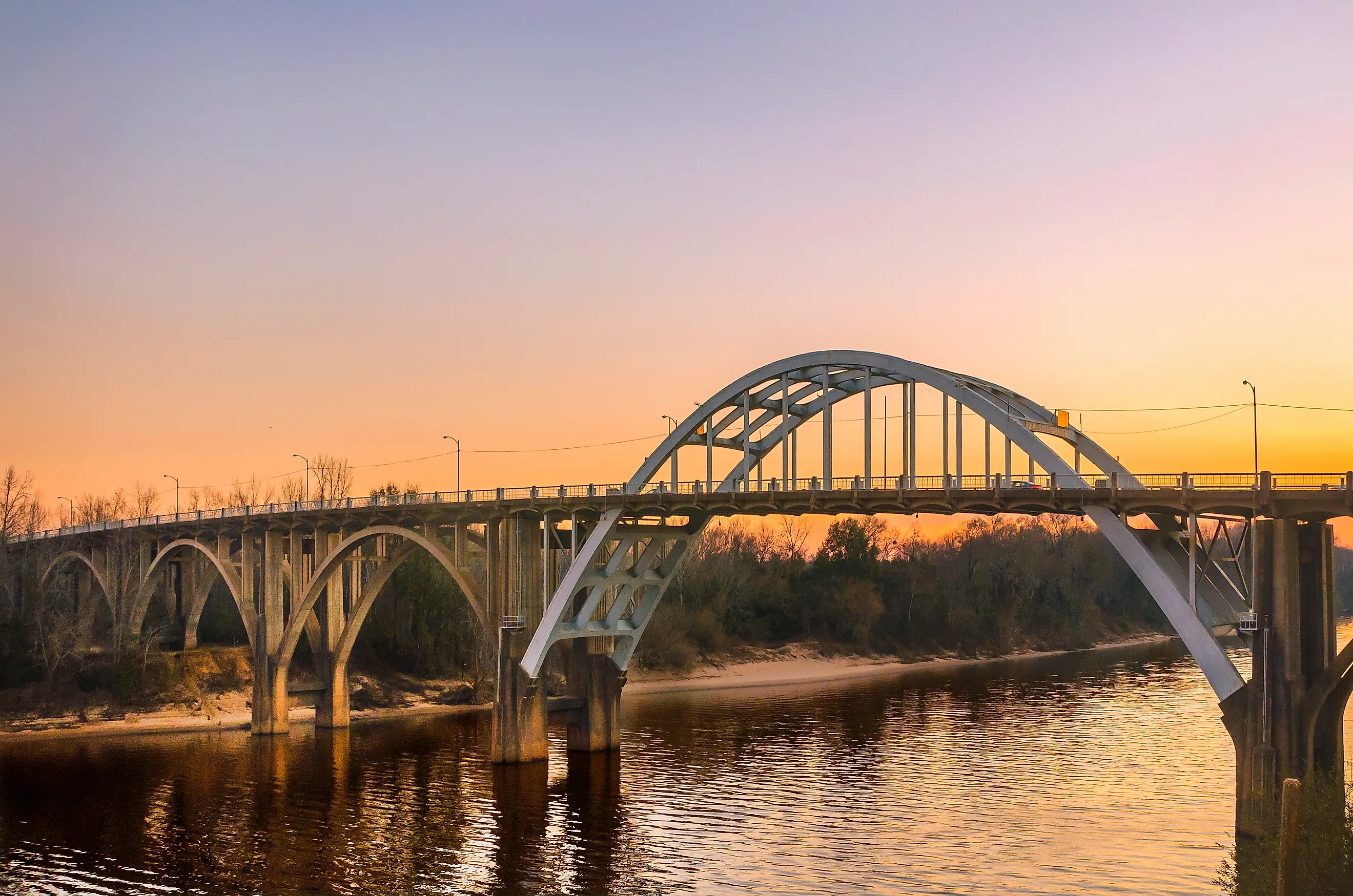
Wetumpka

Wetumpka sits on the Coosa River where the river breaks through the fall line between the Piedmont and the coastal plain. The Bibb Graves Bridge from 1937 carries Highway 14 across the river in a long arched span, with downtown sitting on the east bank and the older neighborhoods climbing the west bluff.
The Wetumpka Impact Crater is the local curiosity that the town wears on its civic identity. A meteor hit this spot about 83 million years ago and left a five-mile crater that geologists confirmed in the 1990s. The crater is now considered the most-studied Mesozoic impact site in the eastern United States, and a small visitor display in town walks through the evidence. Gold Star Park downtown runs walking trails along the Coosa with picnic areas and a small amphitheater that the city books through the warm months. The Kelly Fitzpatrick Center for the Arts in the Old Bank Building handles the downtown gallery side.
Eufaula

Eufaula stands high on the bluff above Lake Eufaula, a 45,000-acre reservoir on the Chattahoochee River that doubles as the Alabama-Georgia border. The town's historic district covers two square miles of antebellum and Victorian homes that include more than 700 structures listed on the National Register, which makes it one of the largest historic districts in the state.
The Shorter Mansion at the head of Eufaula Avenue is the most photographed of the homes, a Greek Revival columned house built in 1884 and now run by the Eufaula Heritage Association as a museum. The Seth Lore and Irwinton Historic District runs north from there for blocks of shaded streets and porches that have been holding up for over a century. Lakepoint State Park on the lake's north shore covers boating, fishing, golf, and a lodge that the state has operated since 1973. The Eufaula National Wildlife Refuge protects the wetlands at the head of the lake and runs an auto tour route through ponds that hold migratory waterfowl in winter.
Selma

Selma sits on the Alabama River and is best known for the steel arch of the Edmund Pettus Bridge, completed in 1940 and crossed on March 7, 1965 by civil rights marchers later beaten by state troopers. That march and the federal response that followed produced the Voting Rights Act of 1965 a few months later. The bridge is now a National Historic Landmark.
The Selma Interpretive Center at the foot of the bridge runs as a National Park Service site with photographs, oral histories, and walking-tour materials for visitors moving toward the bridge or back through downtown. The Old Depot Museum a block away covers the broader local history through the antebellum and Civil War years. The National Voting Rights Museum on the east bank of the river continues the civil rights narrative through artifacts, voter rolls, and testimony from march participants. Riverfront Park runs along the water below the bridge with benches that look back at the steel arch from below.
Demopolis

Demopolis was founded in 1817 by French Bonapartist exiles attempting to grow olives and grapes on the bluff above the Tombigbee River. The Vine and Olive Colony collapsed within a decade and Anglo-American settlers took over the planting, but the French street names and Greek civic names survived. The town now sits at the confluence of the Tombigbee and Black Warrior rivers, with Foscue Creek Park running campsites and boat ramps along the riverbank.
Bluff Hall, a Greek Revival townhouse built in 1832 above the river, opens for tours and runs as a museum of antebellum Demopolis decorative arts. Gaineswood, a few blocks away, is the more architecturally striking of the two. It is a National Historic Landmark built between 1843 and 1861 with domed ceilings, a porte cochere, and interior plasterwork designed by its owner Nathan Bryan Whitfield, who supervised the construction himself for nearly two decades. The Demopolis River Walk runs along the bluff for about a mile of paved path with the rivers in view the whole way.
Camden

Camden lies a few miles east of the Alabama River in Wilcox County, in the heart of the Black Belt cotton country. The town has fewer than 2,000 residents but it works as the base for the surrounding Black Belt arts and history that draws visitors who specifically came for both.
The Gee's Bend Ferry crosses the Alabama River five miles west of Camden and connects the mainland to the Gee's Bend community, whose women quilters have shown at the Whitney, the Met, and the Tate Modern. The ferry runs five days a week and the trip across the water takes about six minutes. Black Belt Treasures Cultural Arts Center on Broad Street in Camden shows the work of more than 450 artists from the surrounding counties, including the quilters, woodturners, and ceramicists who keep regional craft traditions alive. Roland Cooper State Park north of town covers the Dannelly Reservoir with camping, fishing, and birding through the wooded swampland that the river maintains.
Guntersville

Guntersville sits on the south shore of Lake Guntersville, the largest lake in Alabama at 69,100 acres, formed in 1939 by the closure of Guntersville Dam on the Tennessee River. The lake is part of TVA's chain of reservoirs and the town curves around the eastern shore with marinas, boat ramps, and downtown blocks that all face the water.
Lake Guntersville State Park sits on the northeastern shore with 36 miles of trails, an 18-hole golf course, a lodge above the lake, and a daily bald-eagle program in winter when the resident pair returns to nest in the trees above the campground. The state park also runs the only zipline on TVA property. The Guntersville Museum and Cultural Center in the old armory downtown covers local history through the Cherokee removal and the 1939 lake creation, when the rising water flooded the original townsite and the residents moved to higher ground.
Gadsden

Gadsden sits along the Coosa River in northeast Alabama and runs a downtown that has rebuilt itself around historic Broad Street and a riverfront promenade. The city has about 33,000 people and supports more cultural institutions and restaurants than most of the towns on this list. The Coosa runs north-south through downtown with the Memorial Bridge crossing in the middle.
Noccalula Falls Park, on the north edge of town, drops Black Creek about 90 feet over a sandstone ledge into a small gorge that the city has bridged for visitor viewing. The Cherokee legend the falls are named for, the chief's daughter Noccalula who leaped to her death rather than marry against her wishes, runs as a bronze statue at the falls overlook. The park also covers a pioneer village, a botanical garden, and a 1933 covered bridge that was moved here from elsewhere in Etowah County. The Gadsden Museum of Art downtown shows regional artists in a renovated Carnegie library building.
Magnolia Springs

Magnolia Springs lies along the spring-fed Magnolia River on the Alabama Gulf Coast, about ten miles inland from the bay. The town's main street is Oak Street, lined with live oaks dripping Spanish moss, the kind of road that local residents like to call a tunnel.
The Magnolia Springs Post Office has delivered mail by boat since 1916, which makes it the only year-round river mail route in the contiguous United States. The route covers about 30 stops along the river twice a day, with the carrier reading addresses off the docks of the houses lining the water. The Weeks Bay National Estuarine Research Reserve a few miles south runs boardwalks and trails through the wetlands at the head of Mobile Bay, with a visitor center that walks through coastal ecology and the carnivorous pitcher-plant bog that the reserve protects.
Nine Alabama River Towns Worth The Stop
Nine river towns, seven rivers between them. Florence and Guntersville lean into the Tennessee. Wetumpka and Gadsden take the Coosa. Eufaula faces the Chattahoochee. Selma, Demopolis, and Camden run along the Alabama and the Tombigbee. Magnolia Springs gets the smallest of the rivers and uses it the most distinctively. Each town stayed because the river stayed, and the towns still look the part.