Which Countries Border Ghana?
Ghana is an African state occupying an area of about 92,099 sq miles and has over 28 million residents. It is surrounded to the eastern side by Togo, Cote d’Ivoire to the western side, and Burkina Faso to the north. The country shares its southern border with the Gulf of Guinea and the Atlantic Ocean.
The name "Ghana" is a Soninke term which means "Warrior King". Ghana has diverse religious, linguistic and ethnic groups with 11 government-sponsored languages. Over 23% of the residents are Muslims while about 67% are Christian and 5% practice their traditional faith.
Ghana does not have a natural harbor because of the strong surf which pounds its coastlines; instead, they have two artificial ports which were built at Tema and Takoradi. The country’s present-day boundary was established when the British Gold Coast was formed in the 1900s, and it is about 1,505 miles long.
Countries Bordering Ghana
1) Cote d'Ivoire
Cote d’Ivoire is an independent West African state which is bordered by Ghana to the east, Mali to the north, and Liberia and Guinea to the west. The country occupies an area of about 124,500 sq miles of which 1,720 sq miles is water while land covers about 122,780 sq miles. Cote d’Ivoire has maritime claim over 200 nautical miles continental shelf, 12 nautical miles of territorial water, and about 200 nautical miles as their EEZ (exclusive economic zone). The general terrain of the country can be described as a rising plateau which rises steadily from the south to about 1,640 ft above sea level in the north.
The country was a West Africa powerhouse during the 1960s and 1970s, but the political crisis which affected the country in the 1980s contributed to their social and political turmoil. The official language of Cote d’Ivoire is French, but the locals’ converse in numerous 78 other dialects including Cebaara Senuto, Anyin, Dan, Dioula, and Baoule among others. The main religious groups in the country are Islam and Christianity among other indigenous religions.
Ghana-Ivory Coast Border
The Ghana-Ivory Coast boundary is about 447 miles long and located on the western side of Ghana. The current border was agreed upon by the two states in 1989. The 249-mile long River Tanois forms a small part of the international border. Some of the places near the border include Manzanouan village, Niable, Takikro, and Tambi in Ivory Coast and the town of Sampa in Ghana. One of the crossings on this border is in Elubo, Ghana. Other two customs entry-points include the one in Gonnokuram town on the way to Sunyani and the remote post in Oseekodwokrom.
2) Burkina Faso
Burkina Faso is an independent state which occupies an area of about 105,900 sq miles. Togo is bordered by six countries, and this includes Togo, Benin, Niger, Mali, Ivory Coast, and Ghana. The Francophone state has a population of over 20 million. Ouagadougou is the capital city of Burkina Faso. The country is situated between the Gulf of Guinea and the Sahara desert, with River Niger to the south.
The terrain of Burkina Faso includes desert to the north and some green land with fruit trees and forests to the south. A bigger part of the central region of the state is in the savanna plateau. Burkina Faso has two kinds of country-sides. A considerable portion of Burkina Faso is covered by the peneplain which forms some few hills in some regions. There is a sandstone massif to the southwestern parts of the country with the highest elevation at 2,457 ft being Tenakourou. The country’s terrain is relatively flat with its lowest at Black Volta.
Ghana-Burkina Faso Border
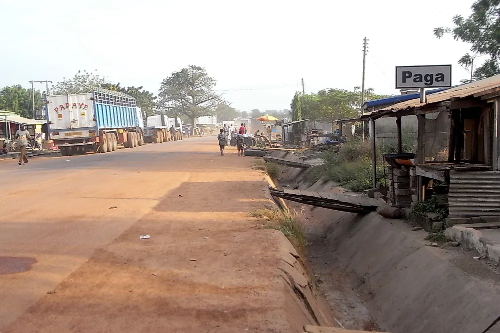
The 374-mile long border is on the northern parts of Ghana. Some of the rivers which form part of this international border include River Oti and Black Volta. There are numerous informal crossing points along the Ghana-Burkina Faso boundary and two customs checkpoints. The main one is in Paga, on the upper East parts of Ghana. The less used crossing point is at Hamale on the northwestern corner of Ghana. Paga is the capital of the Kassena-Nankana West district, and it is about 103 miles to the south of Ouagadougou and can be accessed through the N5 highway which links Burkina Faso to Ghana.
3) Togo
Togo is a West African independent state which is bordered by Burkina Faso, Benin, and Ghana. It is a small sub-Saharan nation which is made up of a long strip of land. Togo has a 35-mile long shoreline along the Guinea Gulf and the Bight of Benin. The widest part of the state is 99 miles wide, and it stretches for about 360 miles to the north. Togo has six geographical areas, and this includes coastal region, Ouatchi Plateau, Guinean forest-savanna mosaic ecoregion, tableland (which is drained by Mono River), Togo Mountains, and the sandstone plateau. There are numerous lakes in the country with the biggest being lake Togo. The country has over 7.6 million residents, and it occupies an area of about 22,008 sq miles making it one of the smallest states in the continent. Togo became an independent nation in 1960, and the country’s economy is dependent on agriculture.
Ghana-Togo Border
The 682-mile long Togo-Ghana boundary is on the eastern parts of Ghana and western parts of Togo. The main border crossing between Togo and Ghana is in Aflao, and it is the only recognized checkpoint between the two governments. Aflao is in Ketu South District, and it served as a slave trade market during the eighteenth century. Another border crossing is in Senkase. Senkase is a village which is some few miles from the Ghana-Burkina Faso-Togo tripoint. Some of the cities on the boundary include Kodjoviakope in Togo which is close to Lome and Badou.


