What Type Of Climate Does Rwanda Have?
Rwanda is situated south of the Equator in east-central Africa. The nation is bordered by Tanzania to the east, DR Congo and Lake Kivu to the west, Uganda to the north, and Burundi to the south. Its capital and the largest city is Kigali. Despite being just two degrees south of the Equator, the nation experiences a temperate climate due to its high elevations. The weather and climate in the country can be described as pleasant.
Geography
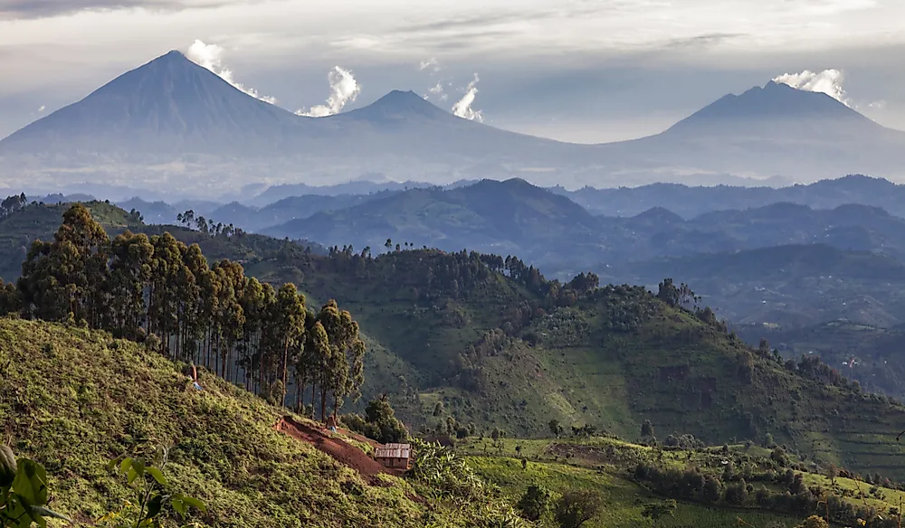
Rwanda is described as a "Land of a Thousand Hills" due to green rolling hilly landscape. The rugged mountain chains are the most dominant features in the country. They run from north to south and form part of the Congo-Nile divide. The Virunga Mountains are found to the north-west part of the country, while Mount Karisimbi is the highest point in the country at an elevation of 14,787 feet. Forests are found in the medium to low altitudes of the Virunga Mountains while sparse vegetation and shrubs are found above 9,800 feet due to the colder climate which has freezing temperatures of about 32-degree Fahrenheit during the night. The summit of Mount Karisimbi is often covered by hail or snow.
To the south of the Virunga Mountains, the country is mountainous. The highest peaks in the Murambi Province are 8,900 feet while the peaks in the Nyungwe Forest reach 8,200 feet. The swampy Akagera River Valley to the east has an elevation of 4,000 feet. The central highlands are comprised of rolling valleys and hills. The Congo-Nile divide, a low-lying depression which borders Lake Kivu is found to the west of the country. Most of the nation's rivers are found to the east except for the Ruzizi which drains the waters of Lake Kivu into Lake Tanganyika. River Kagera is the largest river on the eastern side and forms a significant part of the boundary with Burundi and Tanzania.
Climate and Rainfall
The nation's climate is mainly influenced by the oscillating effects of the Intertropical Convergence Zone which brings about the convergence of the Indian Ocean easterlies, Atlantic Westerlies, and the southeast and northeast monsoon winds. Like the rest of tropical Africa, the nation experiences a dry season and a wet season. The precipitation in the country can be described as bimodal. Most of the precipitation occurs between March and May while the next batch of precipitation occurs from mid-September to mid-December.
The different main precipitation periods are as a result of the ITCZ's zonal and meridional arms. The ITCZ zonal arm moves from the west to the east passing over the Congo basin, and it provides subtropical Africa with much of its rain. The ITCZ meridional arm, on the other hand, provides more variable and shorter rains, as it passes from the northeast to the southwest. The second arm of the ITCZ passes over Lake Victoria which increases its rain-bearing potential to the benefit of countries lying to the south and southeast such as Rwanda, Burundi, and part of DR Congo.
Altitude and the nation's position also influence the distribution of the rainfall. The western and north-western parts of the country are generally wetter and experience climatic conditions that range from semi-humid to humid and moist. The annual average rainfall ranges from 51.18 inches around Lake Kivu to 78.74 inches in areas such as Nyungwe. The average rainfall around the Akagera National Park is about 29.5 inches. Clouds mainly cover the sky above the Virunga Mountains in the Volcanoes national park. In the mountainous areas, rainfall is more abundant with showers occurring throughout the year.
Temperatures
The elevation of the country's landscape contributes to the nation's mild temperatures. There are however significant temperature variations between the drier and warmer interior highlands and the volcanoes found to the northwest that experience heavy rainfall and lower temperatures. Temperatures around Lake Kivu are about 77 degrees Fahrenheit. Areas around the Nyungwe Forest National Park are cooler and experience temperatures of about 59.9 degrees Fahrenheit while the Volcanoes National Park is chilly with temperatures of about 49.1 degrees Fahrenheit. The temperatures in the Nyugwe Rainforest sometimes soar to about 86 degrees Fahrenheit. The average temperatures in the Akagera National Park are 75.2 degrees Fahrenheit.
Sunshine
The skies above Rwanda are normally cloudy during the wet months. The drier months between June and July experience more frequent sunshine. June and July have the highest number of sunshine hours.
Weather in Kigali
Kigali is situated at the center of the country at an elevation of 5,000 feet above sea level. It is a beautiful and small city that has a variety of flowering trees and shrubs. It receives about 37.5 inches of rainfall per year with April being the rainiest month while the period between June and August receives the least amount of precipitation. The average temperatures in Kigali are about 82 degrees Fahrenheit.
When to Visit and What to Pack
The country is home to nearly a third to the Mountain Gorilla population. Since Rwanda offers both savannah and rainforest safari experiences, the best time to visit the nation depends on the location one wants to tour. The best time to view wildlife is the drier periods between June and September and January to February because wildlife moves closer to lakesides and riverfronts. In the rainforest areas to the west and northwest, gorilla viewing can be done throughout the year. Trekking is, however, easier in the drier months. In Nyungwe Forest, primate viewing is easier in the wetter months when monkeys and apes feed in predictable territories. During winter between June and August, spring, or autumn clothes recommended are a jacket and sweater for the evenings. In the Virunga Mountains, warm clothes are recommended. When going for nature walks and hikes, long-sleeved shirts, long trousers, light rain jackets, and a hat are recommended.


