Which Countries Border Paraguay?
Paraguay is a country located in the central region of South America, where it covers a total area of 157,048 square miles. By area, it is the smallest landlocked country in the Americas. Paraguay has a population size of approximately 6.89 million, and 10% of this total live in the nation's capital, Asuncion. The country has two official languages, Spanish and Guarani, both of which are spoken and understood by the vast majority of the population.
The landscape of Paraguay is characterized by two distinct regions: the Chaco, which is a large and arid plains area, and the Pareneña, a large area of hills and valleys. A number of rivers cross through the country, some of which have extensive floodplains. Additionally, Paraguay is home to a forested, highland region. Politically, the country is divided into 17 departments. The nation's capital, Asuncion, belongs to an independent district.
As a landlocked country, Paraguay has no direct access to the ocean and is instead surrounded by other nations. A lack of access to the ocean means that the country must maintain positive political relationships with its neighbors in order to have port access and be competitive in international trade. Paraguay shares its borders with three countries: Bolivia, Brazil, and Argentina.
What Countries Border Paraguay?
Bolivia
The border between Bolivia and Paraguay runs for 466 miles along the north western edge of Paraguay, separating the Alto Paraguay department from Bolivia. The border, which is the shortest of the three, moves north from the boundary with Argentina and later turns in an eastern direction toward the boundary with Brazil. This region of Paraguay is known as Alto Chaco, which is where the plains begin to develop hilly terrain. The border between these two countries also holds the northernmost point in Paraguay, known as the Hito VII Fortin Coronel Sanchez pillar.
A border dispute between Paraguay and Bolivia existed for 74 years. The dispute, which began with the Chaco War (1932-1935), is believed to be related to a large oil reserve that both countries wanted to control. Paraguay eventually won control of approximately 66% of the entire region (about 22,000 square miles of land). The war, supported by two opposing oil companies, is remembered as the deadliest encounter of the twentieth century in South America. Over 70 years passed before any petroleum was located, and the discovery occurred in an area that was declared as part of Bolivia after the war. In 2009, the presidents of Bolivia and Paraguay came together to sign an agreement that officially ended the ongoing dispute between the two countries. At that time, both leaders expressed interest in developing their natural resouce extraction industries so that both countries could reap the benefits.
Brazil
The border between Brazil and Paraguay runs for 801.5 miles along the eastern edge of Paraguay, separating the country from two states in Brazil: Paraná and Mato Grosso del Sur. Paraguay and Brazil defined their respective territories in 1872 through the signing of a peace treaty that ended the Paraguayan War. Today, the two countries share the Itaipu Hydroelectric Dam, which is located along the Paraná River and forms part of the southeastern border. The dam is recognized as the second largest hydroelectric power plant in the world, and Paraguay produces an abundance of electricity, which is sold to Brazil. In 2009, the government of Brazil agreed to increase its payments to Paraguay for its energy production, which lead to an improved political relationship between the two countries.
The border runs in a roughly north-south direction. At its southern tip, the border essentially begin at the city of Foz do Iguacu, Brazil. It heads in a northern direction and is marked by the Paraná River, and follows the river until it veers east. In this region, the geography of Paraguay is made up of the Paraná Plateau, which extends into the southern area of Brazil. This plateau region is filled with forests and other woodland plants, and stands at an elevation of between 591 and 1,509 feet above sea level. Aa the Paraná River continues eastward into Brazil, the border between Paraguay and Brazil is characterized by mountainous terrain and is marked by the Apa River. The northern section of the boundary runs along the hot and arid Chaco region.
The most widely recognized crossing between Paraguay and Brazil is the Friendship Bridge, which spans the Paraná River between the Ciudad del Este of Paraguay and the Foz do Igaucu of Brazil. The bridge runs approximately one-third of a mile and was inaugurated in 1965.
Argentina
The border between Argentina and Paraguay runs for just over 733 miles, making it the longest international border in Paraguay. The boundary is located along the southern edge of Paraguay, where it largely follows three rivers: the Paraná, the Paraguay, and the Pilcomayo. Paraguay and Argentina defined their shared border in the late 19th century after the Paraguayan War, which caused Paraguay to lose some of its territory to Argentina. The westernmost point of Paraguay is located at the Hito I Esmeralda pillar, which separates Paraguay from the Boquerón deparment in Argentina. The capital of Paraguay, Asuncion, is situated along the border with Argentina, separated only by the Paraguay River. Both Argentina and Paraguay have embassies and consulates located in the neighboring country.
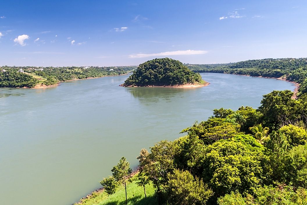
The point where the borders of Argentina, Brazil, and Paraguay meet is known as the Triple Frontier. The area marks the joining of the Paraná River and the Iguazu River. Additionally, it is the location of 3 cities: Foz do Iguacu (Brazil), Ciudad del Este (Paraguay), and Puerto Iguazu (Argentina). Together, these cities have a population of approximately 770,000, and the area is a popular tourist attraction given its close proximity to the Iguazu Waterfall. Here, each country has built a monument to display its national colors and visitors can see all three nations from any of the monuments.