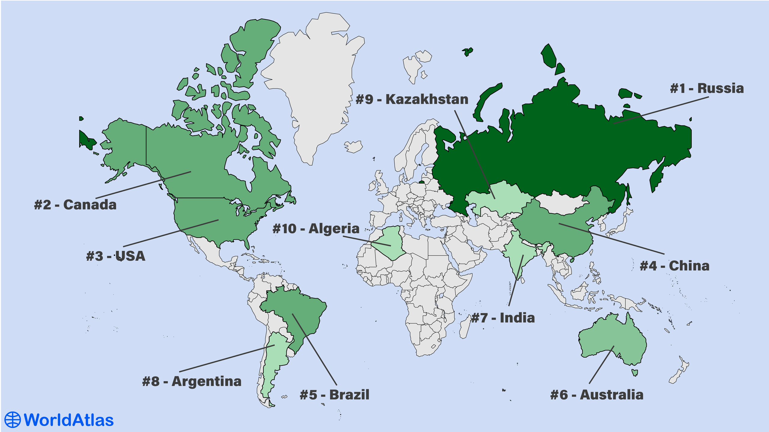
The Largest Countries In The World
By total geographical area, the largest country in the world is Russia with an area of 17,098,242 km2, which covers approximately 11.5 percent of the world’s land surface. Russia has nearly twice the area of either Canada or the United States, which are the second and third-largest countries in the world. For added perspective, the total land area of the Earth amounts to 148,428,950 km2, which is shared by 195 countries.
The Largest Countries By Total Area
| # | Country | Total Area km2 | Total Area mi2 |
|---|---|---|---|
| 1 | Russia | 17,098,242 | 6,601,668 |
| 2 | Canada | 9,984,670 | 3,855,102 |
| 3 | United States | 9,826,675 | 3,794,100 |
| 4 | China | 9,596,960 | 3,705,407 |
| 5 | Brazil | 8,515,770 | 3,287,957 |
| 6 | Australia | 7,741,220 | 2,988,901 |
| 7 | India | 3,287,263 | 1,269,219 |
| 8 | Argentina | 2,780,400 | 1,073,518 |
| 9 | Kazakhstan | 2,724,900 | 1,052,089 |
| 10 | Algeria | 2,381,741 | 919,595 |
Jump to the table of the 50 largest countries in the world.
1. Russia - 17,098,242 km2

- Population: 145,165,000
- Time zones: UTC +2:00 to +12:00
Russia, the world’s largest country, extends across the northern hemisphere, covering about 38% of the continent of Asia. The boreal forests of Russia, also known as the taiga, represent the most expansive forested region in the world. Covering more than 12 million square kilometers, the boreal forests of Russia are even more extensive than the Amazon Rainforest.
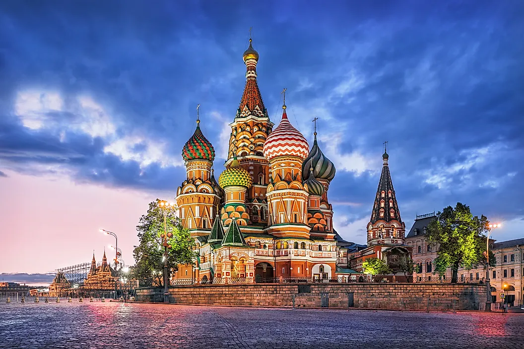
Between the early 17th century and the mid-18th century, Russia gradually incorporated the lands of present-day Siberia, the vast province east of the Ural Mountains that encompasses most of northern Asia. At its peak in the late 19th century, Russia covered about 22.8 million square kilometers, which is over 15%, or nearly one-sixth, of the total land area on Earth. Russia also has the most kilometers of rivers in the world with a total river length of 2.3 million kilometers across 120,000 rivers over 10 km long.
2. Canada - 9,984,670 km2

- Population: 42,069,000
- Time Zones: UTC −8:00 to UTC −03:30
Canada is one of two countries, the other being Russia, which borders three oceans, with coastlines at the Atlantic Ocean, Pacific Ocean, and Arctic Ocean. Altogether, these shores make up the most extensive coastline in the world at just over 200,000 kilometers in total length.
In the 17th century, Canada was originally a colonized region of European settlers in the northeastern portion of North America that is today a part of Québec, Nova Scotia, Newfoundland, and the surrounding areas. These settlements began as trading posts but soon increased their influence throughout the region. The Hudson Bay Company (HBC), in particular, occupied an extensive amount of land surrounding the entire Hudson Bay and into parts of what is not western Canada and Nunavut. In 1870, the HBC sold the massive territory of Rupert’s Land to Canada, which is about one-third of the country’s present-day geographic area. In the following decade, Canada continued expanding west to the Pacific coast, where its borders remain to this day.
In the east, Canada features numerous bustling cities, estuaries and salt marshes, and a rugged coastline bordering the Atlantic Ocean. In the west, Canada claims 2.26 million square kilometers of mountain range alongside the Pacific Ocean, which accounts for 24 percent of the country’s land area. There are 50 Canadian peaks, within Yukon, Alberta, and British Columbia, that reach over 3,350 meters in elevation.
3. United States - 9,826,675 km2

- Population: 341,963,000
- Time Zones: UTC −10:00 to UTC −5:00
The United States (U.S.) is made up of 50 states, the most of any country in the world. Its largest state, Alaska, covers about 1.7 million square kilometers, is larger than 177 countries and territories in the world, and is similar in size to countries such as Mexico, Libya, and Mongolia.
The U.S. began as colonies of Great Britain on the eastern coast of North America. After achieving independence in 1776, these former colonies extended the western border from the Appalachian Mountains all the way to the Mississippi River. In 1803, the Louisiana Purchase acquired over 2.1 million square kilometers from France. Just decades later, in 1848, the U.S. incorporated land extending to the Pacific coast following the Mexican-American War. Throughout the remainder of the 19th century and in the 20th century, the U.S. would make another land purchase, obtaining Alaska from Russia in 1867. In 1959, the country would add its 50th and final state, Hawaii.
Note: When excluding the area of coastal and territorial waters, China is technically larger than the United States, but because these figures are unknown for China, the United States is consistently ranked as a larger country.
4. China 9,596,960 km2

- Population: 1,410,474,000
- Time Zones: UTC +8:00
China is a geographically diverse country located in eastern Asia. The terrain of the country ranges from the some of the highest mountains in the world, to tropical beaches, to expansive plains. Along the southwestern border, the Chinese Himalayas extend 2,400 kilometers. The Tibetan Plateau is the world’s highest and most expansive plateau in the world, covering 2.5 million square kilometers and averaging 4,500 meters above sea level.
China’s history dates back thousands of years to some of the earliest human civilizations. Today, China is the sixth oldest country in the world, dating back to 2070 BCE. While capitals were established during the Zhou Dynasty in the mid-11th century BCE, it was not until the Qin Dynasty, around 200 BCE, that the country was unified. Today, China is one of the world’s most populous nations and has a momentous role in global economics as the largest exporter of manufactured goods.
5. Brazil - 8,515,770 km2

- Population: 205,223,000
- Time Zones: UTC −5:00 to UTC −2:00
Brazil is the largest country in South America, covering more than 47% of the continent’s total area. Recognizable by its vibrant cities and natural wonders, Brazil has a wonderful blend of culture. The country features the longest beach in the world, Praia do Cassino Beach, stretching 254 kilometers from the Rio Grande to the border with the neighboring country, Uruguay.
Brazil’s attractions include some of the most-immense natural wonders in the world, such as the Amazon River (6,400 kilometers), the Iguaçu Falls (82 meters), and the largest wetland in the world, the Pantanal (140,000 - 160,000 km2). Brazil contains 60 percent of the Amazon Rainforest which, in its entirety, spans about 6.7 million square kilometers. The rainforest alone would be the seventh largest country in the world. Brazil also has the most national parks of any other country in South America, with 68 national parks home to diverse landscapes and wildlife.
6. Australia - 7,741,220 km2

- Population: 27,307,000
- Time Zones: UTC +8:00 to +10:00
Australia, the largest country in the region of Oceania, is unique for conterminous with its continent. The country has the sixth longest coastline in the world, with 25,760 kilometers of tropical, desert, grassland, and temperate landscapes. The landscape encompasses wilderness, beaches, islands, and the 2,300-kilometer-long Great Barrier Reef.
In 1788, a single border along 135 degrees east longitude divided the Australian continent into New South Wales in the east and New Holland in the west. By 1989, after 200 years of changes in political geography, Australia’s present-day borders came to be.
One of the most well-known characteristics of this country is the desert-like heartland of Australia, the Outback. Covering 5.6 million square kilometers and accounting for 70% of Australia’s total area, the Outback itself would be large enough to rank seventh on the list of the largest countries in the world.
7. India - 3,287,263 km2

- Population: 1,384,380,000
- Time Zones: UTC +5:30
India is Asia’s second-largest country and the most populous country in the world. India is home to some of the largest, wonderous attractions in the world. The highest-reaching mountain range in the world, the Himalayas, extends within India’s borders and accounts for 16% of the country’s total geographical area. In the northwest, the Thar Desert is the 19th largest desert in the world and it is found primarily in the Indian state of Rajasthan. India also contains several colossal manmade structures, in both size and acclaim, such as the Taj Mahal, an ivory-white marble mausoleum. The Taj Mahal is also included as one of the seven wonders of the world and stands over the Yamuna River at 73 meters in height. Additionally, the world’s tallest statue, the Statue of Unity, in Gujarat, stands at 182 meters tall and commemorates Sardar Vallabhbhai Patel, a leader for Indian independence. Last, India is home to several plains, marshes, coasts, and plateaus that occupy wide swaths of land, such as the Deccan Plateau or the Andaman and Nicobar Island groups.
8. Argentina - 2,780,400 km2

- Population: 47,225,000
- Time Zones: UTC −3:00
Argentina, South America's second-largest country, is characterized by its elongated geography, bordered by over 5,800 kilometers of Andes Mountains to the west and about 4,725 kilometers of Atlantic Ocean coastline to the east.
In the 16th century, Spain settled at the place that is now Buenos Aires, which is today Argentina’s most populous city with over 2.9 million inhabitants. In 1810, Argentina fought a war for independence from Spain, which was achieved in 1816.
Argentina’s total geographical area is larger than the combined area of Bolivia, Chile, Ecuador, Paraguay, and Uruguay. Argentina has a total of 40 national parks that make up 4% of the country’s total area, covering about 38,000 km2. Today, the area of Argentina’s parks alone is larger than that of 88 countries.
9. Kazakhstan - 2,724,900 km2

- Population: 20,485,000
- Time Zones: UTC +5:00 to +6:00
Kazakhstan, Central Asia’s most expansive country, borders the shores of the Caspian Sea in the west and extends nearly 3,000 kilometers, all the way to the Altay Mountains in the east. The country’s geography is defined by an arid and semi-arid continental climate, with cold winters and hot summers. The diverse terrain includes desert, steppe, forest, and mountainous landscapes. Kazakhstan’s largest city, Almaty, is home to just over 2 million people and has nearly doubled its population since 2000.
In its history, Kazakhstan was originally a region inhabited by nomadic tribes as far back as 1000 BCE. Administrative districts were established in the region in the early 13th century after being conquered by Genghis Khan’s Mongol Empire. The Mongol Empire was succeeded by a nomadic state known as the Kazakh Khanate, which ruled the steppe lands in the 15th century before falling to internal conflict in the 19th century. Following the disbanding, the territories making up present-day Kazakhstan became occupied by the Russian Empire until the eventual collapse of the Soviet Union in 1991, when Kazakhstan regained its independence.
10. Algeria - 2,381,741 km2

- Population: 46,839,000
- Time Zones: UTC +1:00
Algeria, Africa’s largest nation, is located in the northern portion of the continent, with a coast along the Mediterranean Sea and a mainland that extends inland to the Sahara Desert. In the north, Algeria’s landscape is comprised of fertile plains, which are separated from the deserts to the south by nearly a thousand kilometers of the Atlas Mountains. The capital and largest city is Algiers, home to 2.9 million people. Agriculture is an important economic factor for Algeria, though tourism has been on the rise in recent years, bringing over half a million international visitors to experience the many natural wonders, arts, and culture of the nation. Algeria covers a geographic area of about 2.381 million square kilometers, more than four times the size of Spain.
Historically, between 6000 BCE and 2000 BCE, Neolithic civilization developed in the region, with animal domestication and agriculture. By 200 BCE, the ancient kingdom of Numidia occupied the land consisting of the coastline of what is now parts of Algeria, Libya, Tunisia, and Morocco. By the 19th century, European colonization campaigns came to the region, with France occupying the country until 1962 when Algeria gained its independence.
Final Thoughts
Throughout history, the borders of countries have been shaped by events like colonial expansion and independence movements. The world's timeline shows an ever-changing pattern of national borders. In the early 1800s, there were over 130 sovereign countries, but by the early 1900s, that number had decreased to just over 75. Since then, the number of countries has steadily increased to 195 in 2024. Despite challenges in maintaining their geographic area, many countries have expanded to immense sizes, with future changes in borders still possible.
The Largest Countries by Area in Each Continent
- The Largest Countries in Africa
- The Largest Countries in Europe
- The Largest Countries in Asia
- The Largest Countries in North America
- The Largest Countries in South America
The 50 Largest Countries In the World Ranked By Total Area
| # | Country or Territory | Total Area km2 | Total Area mi2 |
|---|---|---|---|
| 1 | Russia | 17,098,242 | 6,601,668 |
| 2 | Canada | 9,984,670 | 3,855,102 |
| 3 | United States | 9,826,675 | 3,794,100 |
| 4 | China | 9,596,960 | 3,705,407 |
| - | United States (No Territories) | 9,525,067 | 3,677,649 |
| 5 | Brazil | 8,515,770 | 3,287,957 |
| 6 | Australia | 7,741,220 | 2,988,901 |
| 7 | India | 3,287,263 | 1,269,219 |
| 8 | Argentina | 2,780,400 | 1,073,518 |
| 9 | Kazakhstan | 2,724,900 | 1,052,089 |
| 10 | Algeria | 2,381,741 | 919,595 |
| 11 | DR Congo | 2,344,858 | 905,355 |
| 12 | Danish Realm Kingdom of Denmark (includes Greenland) | 2,220,093 | 857,183 |
| - | Greenland (Denmark) | 2,166,086 | 836,330 |
| 13 | Saudi Arabia | 2,149,690 | 830,000 |
| 14 | Mexico | 1,964,375 | 758,449 |
| 15 | Indonesia | 1,904,569 | 735,358 |
| 16 | Sudan | 1,861,484 | 718,723 |
| 17 | Libya | 1,759,540 | 679,360 |
| 18 | Iran | 1,648,195 | 636,372 |
| 19 | Mongolia | 1,564,110 | 603,910 |
| 20 | Peru | 1,285,216 | 496,225 |
| 21 | Chad | 1,284,000 | 496,000 |
| 22 | Niger | 1,267,000 | 489,000 |
| 23 | Angola | 1,246,700 | 481,400 |
| 24 | Mali | 1,240,192 | 478,841 |
| 25 | South Africa | 1,221,037 | 471,445 |
| 26 | Colombia | 1,141,748 | 440,831 |
| 27 | Ethiopia | 1,104,300 | 426,400 |
| 28 | Bolivia | 1,098,581 | 424,164 |
| 29 | Mauritania | 1,030,700 | 398,000 |
| 30 | Egypt | 1,002,450 | 387,050 |
| 31 | Tanzania | 945,087 | 364,900 |
| 32 | Nigeria | 923,768 | 356,669 |
| 33 | Venezuela | 916,445 | 353,841 |
| 34 | Pakistan | 881,913 | 340,509 |
| 35 | Namibia | 825,615 | 318,772 |
| 36 | Mozambique | 801,590 | 309,500 |
| 37 | Turkey | 783,562 | 302,535 |
| 38 | Chile | 756,102 | 291,933 |
| 39 | Zambia | 752,612 | 290,585 |
| 40 | Myanmar | 676,578 | 261,228 |
| 41 | Afghanistan | 652,867 | 252,073 |
| 42 | South Sudan | 644,329 | 248,777 |
| 43 | France (Including All Territories) | 640,679 | 247,368 |
| 44 | Somalia | 637,657 | 246,201 |
| 45 | Central African Republic | 622,984 | 240,535 |
| 46 | Ukraine | 603,550 | 233,030 |
| 47 | Madagascar | 587,041 | 226,658 |
| 48 | Botswana | 581,730 | 224,610 |
| 49 | Kenya | 580,367 | 224,081 |
| 50 | Yemen | 555,000 | 214,000 |
| - | France (No Territories) | 543,940 | 210,020 |
| - | Denmark (No Territories) | 43,094 | 16,639 |
Total Area is the combined value of a country's land area and water area.Data is sourced from The World Bank and CIA World Factbook.