Pantanal, Brazil
- The area of the Pantanal is the largest tropical wetland on Earth.
- During the wettest part of the year, when the area experiences the most precipitation, the Pantanal wetland and basin can be as much as 80% submerged in water.
- The Pantal is home to 9,000 invertebrate species, 159 mammal species, 53 types of amphibians, 480 reptile species, 400 fish species and some 1000 different types of birds.
The Pantanal, in Brazil, is the largest tropical wetland on Earth. It covers an area estimated at between 54,000 and 81,000 square miles (140,000 to 210,000 square kilometers), with most figures clustering around 66,000 square miles. About 80% of it lies in central-western Brazil, in the states of Mato Grosso and Mato Grosso do Sul, with smaller extensions into eastern Bolivia and northeastern Paraguay. The Pantanal sits inside a vast, shallow basin: each rainy season the rivers spill out across the floor of the basin and turn it into one of the world's most productive wildlife habitats. By the dry season, the water has retreated, leaving pools of fish, mud, and grasslands grazed by some of the densest populations of large mammals in the Americas. Conservationists sometimes call it South America's Serengeti.

Contents:
- How Was The Pantanal Formed?
- Geography Of The Pantanal
- Why Is The Pantanal Important?
- What Lives Within The Pantanal?
- Conservation Efforts
How Was The Pantanal Formed?

The Pantanal sits in a shallow tectonic depression that formed during the rise of the Andes in the Tertiary period. As the mountains pushed up to the west and the highlands eroded down on the Brazilian side, a vast, gently sloping basin opened in between. Over millions of years, sediment from rivers draining the surrounding plateaus filled the depression to a near-flat floor that now sits about 100 meters above sea level. The sediment layer beneath the surface runs hundreds of meters deep, and the soils across the basin grade from sand on the higher edges to silt and clay in the lowest parts. Marine fossils preserved in nearby shale and sandstone suggest the area was once connected to the sea.
What turns the basin into a wetland is the rain. The Pantanal receives about 40 to 55 inches (1,000 to 1,400 mm) of rain per year, almost all of it falling between November and March. Rain that lands across the surrounding highlands is funneled into the basin via the Paraguay River and its tributaries, which include the Cuiabá, São Lourenço, Taquari, Miranda, and Negro rivers. Because the floor of the basin is nearly level, the water cannot drain away quickly. It pools out across the lowlands, slows further as it tangles with vegetation, and sits there until the dry season pulls it back into the river channels.

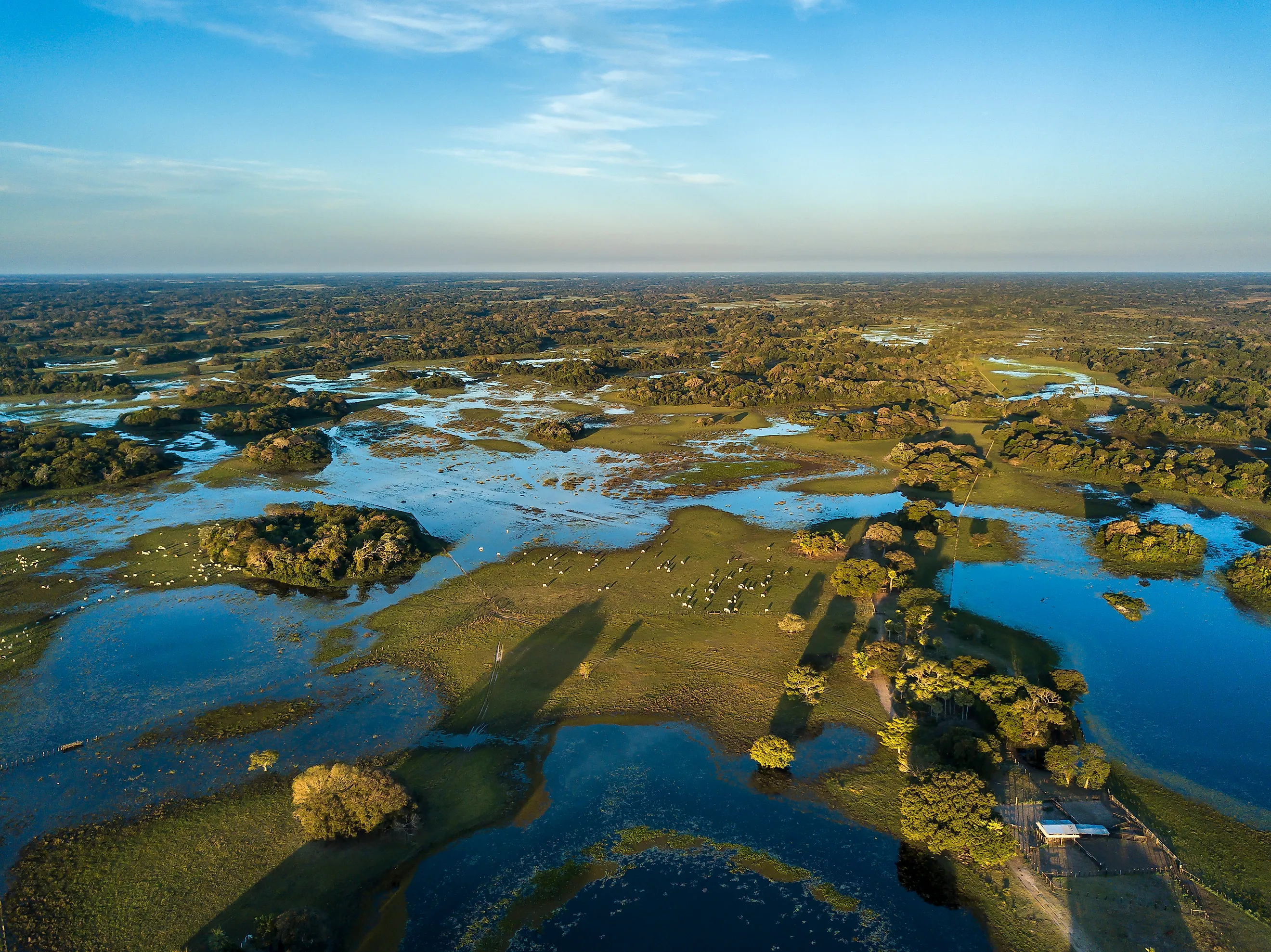
By the peak of the wet season, roughly 80% of the Pantanal's floodplains are submerged. As the rains taper off and the dry months arrive, the water recedes back toward the rivers, leaving behind shallow pools and oxbow lakes scattered across the grasslands. The receding water concentrates fish, snails, and other aquatic life into ever-smaller pools, which become feeding grounds for caimans, herons, storks, and capybaras. The transition between flood and drought, repeating every year, is what drives the Pantanal's productivity.
Geography Of The Pantanal

The wetland stretches roughly 600 kilometers (about 375 miles) north to south along the upper Paraguay River. Its boundaries are defined by where the floodplain meets the surrounding uplands: the Chiquitano dry forests to the west and northwest, the arid Chaco woodlands to the southwest, the humid Chaco grasslands to the south, and the Brazilian cerrado savanna to the east and north. Botanists have divided the basin into as many as 12 distinct subregions based on soil type, hydrology, and vegetation, although the boundaries between them shift with the flood cycle.
The Paraguay River runs along the western side of the Pantanal and provides the basin's main drainage. Water depth along its banks can swing from around 6 feet in the dry season to over 16 feet at the peak of the floods. As the river overflows during the wet season, the surrounding floodplain becomes a slow-moving sheet of water dotted with islands of higher ground, where trees and dry-land vegetation hold out above the waterline. Where the Paraguay River passes through a cluster of hills called Fecho dos Morros (the "Closing of the Hills"), about 36 km upstream of Porto Murtinho on the Brazil-Paraguay border, the channel narrows enough to act as a natural grade control on the entire system's drainage.

Vegetation in the Pantanal is a patchwork rather than a single biome. The wetter, lower-lying parts are dominated by flooded grasslands and aquatic plants. Slightly higher ground supports gallery forests along the rivers, palm savannas where the buriti and acuri palms cluster, and stands of cerrado-style scrub. On the highest islands and along the western edge near the Amolar Hills, dry tropical forest takes over. This mix of habitats inside one basin is part of what makes the Pantanal so productive: a single hectare can contain plants typical of the Amazon, the Chaco, the cerrado, and the dry forests of northeast Brazil.
Why Is The Pantanal Important?

The Pantanal matters in three ways at once: as a hydrological regulator, as a carbon and water reservoir, and as a wildlife stronghold. Its sponge-like absorption of the rainy-season floods buffers the entire Paraná-Paraguay river system. Without it, downstream cities including Asunción and parts of Argentina would face much sharper flood peaks in the wet season and lower flows in the dry. The basin filters sediment and pollutants from the rivers that drain into it, and helps recharge the groundwater of the surrounding plateau region.
For wildlife, the Pantanal is the largest contiguous block of habitat for many species that have been pushed out elsewhere in South America. It holds the world's highest known density of jaguars, the largest remaining populations of giant otters, marsh deer, and hyacinth macaws, and breeding grounds for jabiru storks and an enormous list of other waterbirds. Four contiguous protected areas covering 187,818 hectares were inscribed as the Pantanal Conservation Area on the UNESCO World Heritage List in 2000: the Pantanal Matogrossense National Park together with the Acurizal, Penha, and Doroche private reserves. The inscribed area, however, represents only about 1.3% of the Brazilian Pantanal. The vast majority of the wetland is privately owned, mostly by cattle ranches.
What Lives Within The Pantanal?
The Pantanal supports an extraordinary range of species despite covering a relatively small fraction of South America. Recent surveys have documented around 656 species of birds, more than 159 species of mammals, around 325 species of fish, 98 species of reptiles, 53 species of amphibians, and over 9,000 species and subspecies of invertebrates. About 3,500 species of plants have been recorded in the basin. Density of large animals, rather than total species count, is what sets the Pantanal apart: the dry-season concentration of life around shrinking pools is one of the most concentrated wildlife displays anywhere in the Americas.

Capybaras, the world's largest rodents, are abundant. Adults usually weigh between 75 and 145 pounds (35 to 65 kg), with the largest individuals on record approaching 175 pounds. They graze in family groups along the water's edge and form a major part of the diet of the Pantanal's caimans and jaguars. Yacare caimans, the most numerous large reptile in the basin, are estimated at over 10 million individuals. They share the waterways with green anacondas and a long list of fish species, including the predatory dorado and the fruit-eating pacu.
The Pantanal's most-watched mammal is the jaguar. Pantanal jaguars are the largest in the Americas, with the biggest males approaching 300 pounds, and they have learned to hunt caimans in the water in a way few other jaguar populations do. The wetland is also one of the last reliable strongholds of the giant otter, a 6-foot-long social predator that hunts fish in coordinated family groups. The maned wolf, the largest canid in South America and unmistakable for its black-stockinged stilt-legs and red coat, hunts the savannas at dusk. Smaller mammals include the giant anteater, lowland tapir, marsh deer, and the six-banded armadillo.

Among the birds, the hyacinth macaw is the headliner: the world's largest flying parrot, three feet long with cobalt-blue plumage, and almost entirely dependent on the Pantanal and the surrounding cerrado. Around 6,500 individuals are thought to remain. The jabiru stork, a 4-foot-tall wading bird with a black head and a red collar, is the symbolic bird of the wetland and one of the largest flying birds of the Americas. Greater rheas, the flightless ostrich relatives that are South America's largest birds, share the savannas with the maned wolves. Roseate spoonbills, wood storks, herons, ibises, and dozens of duck species turn the dry-season pools into one of the loudest places in the continent at dawn.
Conservation Efforts
UNESCO World Heritage status protects the formal Pantanal Conservation Area, but it leaves the other 98% of the wetland exposed. The biggest pressures come from cattle ranching, large-scale crop agriculture on the surrounding plateau, the proposed Hidrovia Paraguay-Paraná shipping channel, and increasingly, fire. The Pantanal has been ranched for centuries, and traditional low-density cattle ranching is broadly compatible with the ecosystem. The newer pressures are not.

On the plateaus that drain into the Pantanal, soybean, sugarcane, eucalyptus, and corn monocultures have replaced thousands of square miles of cerrado over the last few decades. The pesticides and fertilizers used on those plantations wash downhill into the rivers that feed the basin. Sediment loads have increased as upland clearing exposes soils to the rains. The Hidrovia proposal, which would dredge and straighten the Paraguay River for over 2,000 miles to allow oceangoing ships to reach inland ports, would alter the basin's flooding cycle in ways biologists believe could collapse the dry-season concentration effect that the wildlife depends on. The project has been repeatedly delayed but has not been formally cancelled.

The most acute recent threat has been fire. In 2020, after a severe drought, fires burned an estimated 7,700 square miles of the Pantanal, roughly a quarter of the entire wetland. Brazil's National Institute for Space Research recorded over 21,000 separate fires in the basin that year, the worst on record. Wildlife losses ran into the tens of millions of vertebrates. Most of the fires were lit deliberately, in many cases to clear pasture or land for crops, and then escaped under drought conditions. Subsequent dry years have brought renewed major fires, and climate models suggest the trend will continue. Recovery from the 2020 burns is partial; some areas have rebounded, others have shifted toward more fire-prone vegetation that will burn again sooner.
Conservation organizations including the World Wildlife Fund, The Nature Conservancy, and Brazilian groups such as Ecotrópica and the Instituto Homem Pantaneiro have been working to expand private reserves, support fire brigades, and push back against the worst of the agricultural and infrastructure pressures. UNESCO, the Brazilian environmental agency IBAMA, and the federal park service ICMBio coordinate management of the inscribed Conservation Area. The longer-term protection of the Pantanal, however, depends on what happens on the ranches, soybean fields, and river ports outside the World Heritage boundary, which is where the wetland is actually being decided.


