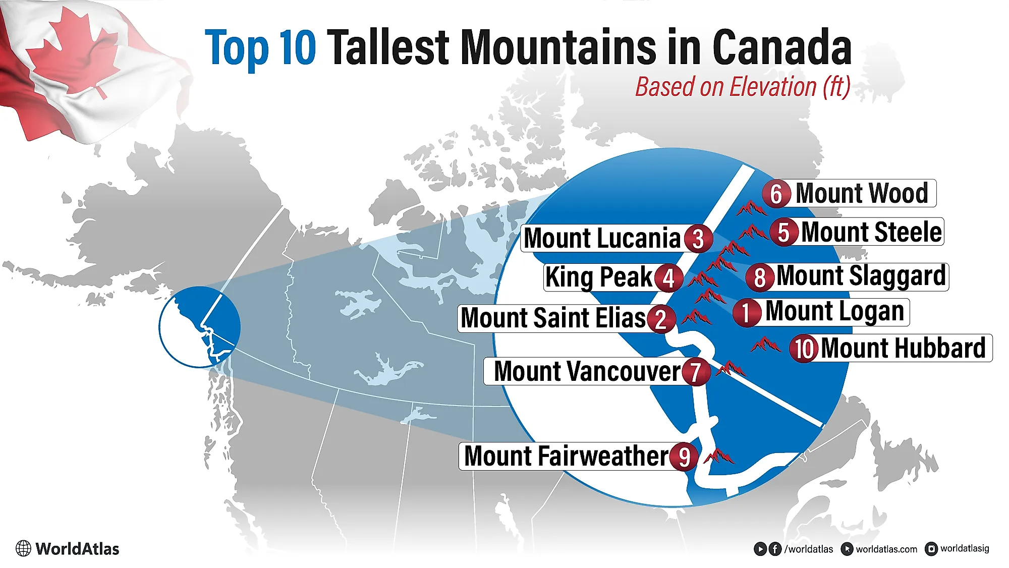
10 Tallest Mountains In Canada
Canada’s highest peaks form a jagged skyline of ice and rock along the remote Saint Elias Mountains, where the Yukon meets Alaska and Pacific storms collide with continental cold.
Here rise the 10 tallest mountains in Canada, led by Mount Logan at 19,551 feet, followed by Mount Saint Elias, Mount Lucania, King Peak, Mount Steele, Mount Wood, Mount Vancouver, Mount Slaggard, Fairweather Mountain, and Mount Hubbard. Together they define Canada’s true high country: a world of vast icefields, crevassed glaciers, and summits that still see relatively few human footprints each year.
Many of these giants anchor international borders, sit inside UNESCO-recognized protected areas, and influence regional climate by capturing huge volumes of snow. Their glaciers feed major rivers and reshape the landscape through avalanches and landslides.
The Tallest Mountains In Canada
| Rank | Highest Mountains in Canada | Elevation |
|---|---|---|
| 1 | Mount Logan | 19,551 feet |
| 2 | Mount Saint Elias | 18,009 feet |
| 3 | Mount Lucania | 17,257 feet |
| 4 | King Peak | 16,972 feet |
| 5 | Mount Steele | 16,470 feet |
| 6 | Mount Wood | 15,945 feet |
| 7 | Mount Vancouver | 15,787 feet |
| 8 | Mount Slaggard | 15,558 feet |
| 9 | Fairweather Mountain | 15,325 feet |
| 10 | Mount Hubbard | 14,951 feet |
Mount Logan
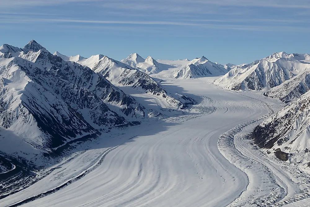
Mount Logan (5,959 m / 19,551 ft) is Canada’s highest mountain and North America’s second-highest peak after Denali. It rises in the Saint Elias Mountains within Kluane National Park and Reserve in southwestern Yukon, near the Alaska border, and feeds the Hubbard and Logan glaciers. The massif includes eleven peaks above 5,000 m and ranks as the world’s 6th most topographically prominent peak. The mountain is still rising due to tectonic uplift. Its elevation was confirmed in 1992 by a Geological Survey of Canada GPS expedition after decades of uncertain measurements. Conditions are severe: winter temperatures on the high plateau hover around −45°C, and limited summer melt sustains a thick ice cap. The first ascent was completed in 1925 by an international team led by A.H. MacCarthy after a long approach from Alaska. Parks Canada introduced stricter climbing rules in 2020 to reduce costly rescues.
Mount Saint Elias

Mount Saint Elias (5,489 m / 18,008 ft) straddles the Alaska-Yukon border, making it the second-highest mountain in both the United States and Canada and the fourth-highest peak in North America. It sits about 42 km southwest of Mount Logan, with its Canadian side in Kluane National Park and its U.S. side in Wrangell-St. Elias National Park. Known in Tlingit as Yasʼéitʼaa Shaa/Was’eitushaa (“mountain behind Icy Bay”), it is famous for extreme vertical relief, rising roughly 18,000 feet in only 16 km from near sea level. The mountain’s proximity to the Pacific brings severe weather—heavy snowfall, prolonged storms, and hurricane-force winds—contributing to a high expedition failure rate. First climbed in 1897 by the Duke of the Abruzzi’s Italian expedition, it saw a second ascent in 1946 and its first winter ascent in 1996.
Mount Lucania
Mount Lucania (5,240 m / 17,190 ft) rises in Canada’s Yukon within the Saint Elias Mountains and ranks as the third-highest peak in both Canada and the range. It is linked by a long ridge to nearby Mount Steele (5,073 m). The Duke of the Abruzzi named Lucania in 1897 after the RMS Lucania, the ship used by his expedition. The first ascent came in 1937, when Bradford Washburn and Robert Hicks Bates used a pioneering airplane drop onto Walsh Glacier; their pilot Bob Reeve barely extracted the plane from deep slush. Washburn and Bates summited Lucania, then Mount Steele, and trekked about 240 km to Burwash Landing. Lost gear from that climb was rediscovered on the glacier in 2022.
King Peak
King Peak (5,173 m/16,972 ft) rises in the Saint Elias Mountains of southwestern Yukon, within Kluane National Park, about 14 km from Mount Logan. Canada’s fourth-highest mountain is a steep, rarely climbed summit with 1,053 m of prominence and serious glacier, ice, and mixed terrain. It was named for surveyor-astronomer William Frederick King, linked to late-1800s boundary work. The first ascent came June 6, 1952, by University of Alaska students Alston Paige, Keith Hart, and Elton Thayer; additional 1952 parties and later climbs tackled ridges and the 7,500-ft southwest face. Access typically requires fly-ins and Parks Canada permits in advance.
Mount Steele

Mount Steele is a major Saint Elias Mountains peak in Yukon and the fifth-highest mountain in Canada. Its elevation is uncertain: older surveys and maps list 5,073 m (16,644 ft), while newer Canadian mapping implies about 5,020±20 m. It was named for Sir Sam Steele of the North-West Mounted Police. The first ascent was in 1935 by Walter A. Wood’s expedition via the east ridge after weather delays and deep snow. Mount Steele is also known for huge slope failures: a 2007 ice avalanche crossed Steele Glacier and registered as a seismic event, followed days later by an even larger ice-and-rock landslide. Another major slide occurred in 2015.
Mount Wood

Mount Wood is a heavily glaciated 4,850-meter summit in Yukon’s Saint Elias Mountains, inside Kluane National Park and Reserve, with Mount Steele as its parent peak. It ranks among Canada’s highest major peaks and sits in the same icefield neighborhood as Logan and Lucania. Surveyor James J. McArthur applied the name in 1900 to honor Zachary Taylor Wood, a North-West Mounted Police inspector in Dawson during the Klondike Gold Rush. The first ascent came on July 25, 1941, when Walter Wood Jr., Anderson Bakewell, and Albert Jackman reached the top via classic glacier, snow, and ice terrain. Its 1,190-meter prominence lifts a broad, icy ridge above the Walsh Glacier basin.
Mount Vancouver

Mount Vancouver is a remote, heavily glaciated Saint Elias Mountains peak on the Canada-U.S. border, managed within Kluane National Park and Reserve. Peakbagger lists its elevation as 4,812 m (15,787 ft) with 2,692 m of prominence and 40.86 km of isolation. The ridge carries three north-south summits: a southern border summit often called Good Neighbor Peak (Boundary Peak 181), a middle peak, and a northern summit entirely in Yukon that many climbers consider highest. Elevations are disputed because USGS assigns 4,870 m to the southern summit, while Canadian maps place it lower, so consistent Canadian values are used for reference.
Mount Slaggard
Mount Slaggard is a remote, heavily glaciated peak in Yukon’s Icefield Ranges of the Saint Elias Mountains, within Kluane National Park and Reserve. It rises to about 4,742 m (15,558 ft), placing it among Canada’s highest mountains, but its prominence is modest at roughly 502 m. About 20 km northwest of Mount Lucania, it forms a ridge “T-junction” with north, south, and west ridgelines linking subpeaks such as South Slaggard (4,370 m). Named for prospector Frank Slaggard, it was first climbed in 1959 via glacier and ridge terrain. Ascents remain rare due to difficult logistics, permits, and harsh weather.
Fairweather Mountain

Mount Fairweather (Tsalxhaan) is a 4,671 m (15,325 ft) peak on the Alaska-British Columbia border, about 20 km (12 mi) from the Pacific. It is the highest mountain in British Columbia and part of the Fairweather Range within the Saint Elias Mountains, mostly in Glacier Bay National Park and Preserve, with the summit bordering Tatshenshini-Alsek Provincial Park. Despite its name, the mountain often has severe storms and heavy snowfall. After unsuccessful attempts in 1926 and 1930, Allen Carpé and Terris Moore made the first ascent on June 8, 1931 via the Southeast Ridge. Later ascents included a 1958 Canadian team and routes on the West and Southwest ridges.
Mount Hubbard
Mount Hubbard is a 4,557 m (14,951 ft) peak in the Saint Elias Mountains on the Alaska-Yukon border, with the Canadian side in Kluane National Park and the U.S. side in Wrangell-Saint. Elias National Park. It was named in 1890 by geologist Israel Russell for Gardiner Greene Hubbard, the first president of the National Geographic Society. Hubbard forms a massif with Mount Alverstone and Mount Kennedy, and it anchors a corner of the international border. Hubbard Glacier lies to the southwest, separating it from Mount Vancouver, while Lowell Glacier sits to the east. The first ascent was in 1951 (Walter Wood and team).
These ten summits outline Canada’s true alpine core, concentrated along the Saint Elias frontier where national boundaries, shifting icefields, and active tectonics intersect. Their height, prominence, and heavy glaciation influence regional weather, river systems, and long-term landscape change. Knowing which mountains reach the country’s highest elevations helps frame Canada’s geography, from coastal ranges to interior plateaus, and anchors further study in geology, climate, mountaineering history, and modern scientific research.