Maps of New Caledonia

The main island of New Caledonia– Grande Terre is cigar-shaped and has rugged mountain ranges running from north to south and rising at two high peaks. The island’s highest point is Mont Panié at an elevation of 1,628m is located in the northeast; while Mont Humboldt at an elevation of 1,618m is located in the southwest of the main island. The Central mountain range forms a natural boundary and separates the east coast from the west coast. The west coast of the island has savannah grasslands while the east coast has dense green vegetation. A ribbon of barrier reef encircles the entire Main Island. This 1,600 km long barrier reef is the world’s 2nd longest and shelters a lagoon having an area of 24,000 sq.km. Numerous small streams flow from the central mountain chain to the lagoon. The Diahot River is the longest river in the island. The three main islands – Ouvéa, Lifou and Maré together make up the Loyalty Islands, which occupy more than one-tenth of the total land area of New Caledonia and are raised coral plateaus.
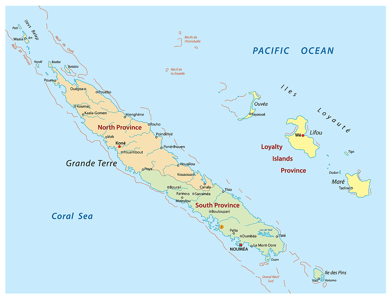
New Caledonia is divided into 3 provinces and 33 communes (municipalities). The provinces are: Province lles (Loyalty Islands Province), Province Nord (North Province) and Province Sud (South Province). The North and South Provinces are a part of the mainland of New Caledonia whereas the Loyalty Islands consists of a series of islands situated off the mainland.
Covering a land area of 18,576 sq.km, New Caledonia is a special collectivity of France, in the southwestern Pacific Ocean. The archipelago comprises of Grande Terre – the principal island, the Loyalty Islands, the Isle of Pines, the Chesterfield Islands, the Belep archipelago and numerous small, sparsely populated islands and atolls.
Located on a peninsula in the southwestern corner of Grande Terre (main island of New Caledonia) is, Nouméa – the capital and the largest city of the island territory. Nouméa is situated on an excellent protected deep-water harbor and hence serves as the chief seaport of New Caledonia. It is also the seat of the regional organization – The Secretariat of the Pacific Community.
Where is New Caledonia?

New Caledonia is a special collectivity of France and a part of Melanesia in the southwestern Pacific Ocean. It is situated to the south of the Equator and to the north of the Tropic of Capricorn; and is geographically positioned both in the Southern and Eastern hemispheres of the Earth. The archipelago is located to the east of Australia; to the north of New Zealand and to the west of Fiji and Vanuatu.
Regional Maps: Map of
Outline Map of New Caledonia

The above blank map represents New Caledonia - a special collectivity of France, in the southwestern Pacific Ocean. The above map can be downloaded, printed and used for geography education purposes like map-pointing and coloring activities.

The above outline map represents New Caledonia - a special collectivity of France, in the southwestern Pacific Ocean.
Key Facts
| Legal Name | Territory of New Caledonia and Dependencies |
|---|---|
| Flag |
|
| Capital City | Noumea |
| 22 16 S, 166 27 E | |
| Total Area | 18,575.00 km2 |
| Land Area | 18,275.00 km2 |
| Water Area | 300.00 km2 |
| Population | 287,800 |
| Currency | Comptoirs Francais du Pacifique francs (XPF) |
This page was last updated on February 25, 2021