9 Most Scenic Drives in Alaska
Alaska has the highest mountain peaks in North America and a road network that crosses some of the continent's most remote terrain. The Seward Highway runs south of Anchorage along Turnagain Arm. The Dalton Highway crosses the Arctic Circle on its way to the oil fields at Prudhoe Bay. Between those extremes, a handful of paved and gravel routes link interior cities with coastal ports and pass through mountain ranges, hot springs, and glacier valleys. Conditions vary by road and season, so planning matters, especially for the gravel and remote segments. The nine drives below cover the range.
Dalton Highway (AK-11)

The Dalton Highway is the only public road in Alaska to cross the Arctic Circle. The 414-mile route follows the Trans-Alaska Pipeline from the Elliott Highway (near Livengood), north of Fairbanks, to Deadhorse, and crosses the Brooks Range along the way. The road mixes gravel and paved sections and requires spare tires and emergency supplies. Studded tires are recommended in winter, which is long in the Arctic; snow can occur in any month. Wildlife along the route includes arctic ground squirrels and muskox. A notable stop is the Arctic Circle BLM Wayside, marked with a sign displaying the latitude at the crossing. The Arctic Ocean is not visible from public roads, but in summer, visitors can reserve the Arctic Ocean shuttle from Deadhorse, which uses restricted oil-field roads to reach the waters of Prudhoe Bay. Not all rental companies allow all of their vehicles on the Dalton Highway, so check before renting.
George Parks Highway (AK-3)

The Parks Highway is a fully paved scenic route running from the Glenn Highway, about 35 miles north of Anchorage, to the interior city of Fairbanks. The 323-mile road passes the town of Talkeetna and Denali State Park. Denali, also called Mount McKinley, reaches 20,310 feet and is visible along the route. Because clouds often cover the peak, only about 30% of park visitors see it unobstructed. Moose, grizzlies, and other wildlife can be spotted along the highway, particularly at dawn and dusk. Just north of Byers Lake, the Alaska Veterans Memorial marks a roadside stop. The highway is maintained through winter, but whiteouts and road closures occur in heavy snow.
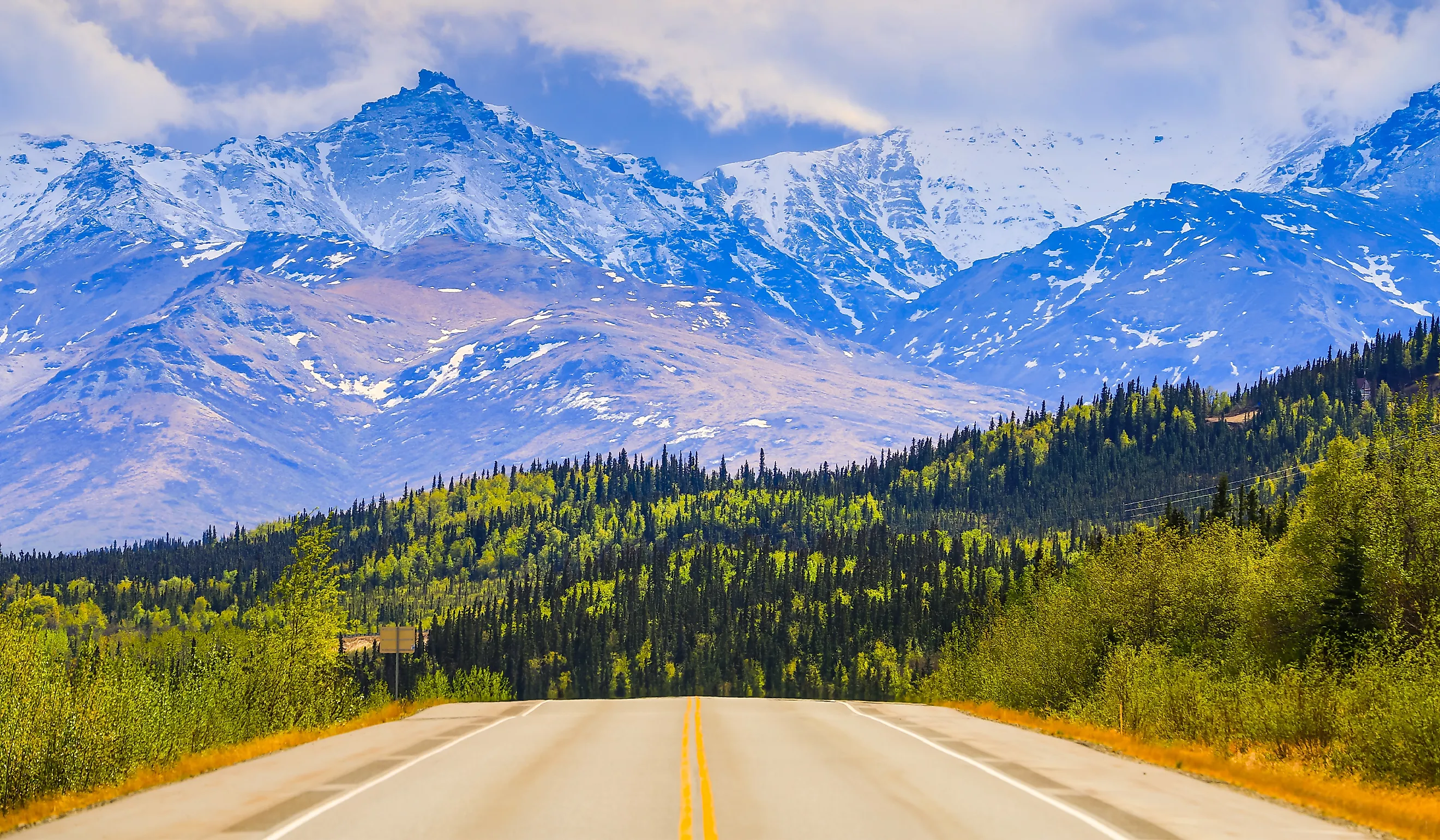
Seward Highway (AK-1, AK-9)

The Seward Highway runs 127 miles from Anchorage down to Seward and is designated an Alaska Scenic Byway, a USDA Forest Service Scenic Byway, and an All-American Road. The route features coastal scenery along Turnagain Arm along with roadside stops and trailheads. Just south of Anchorage, the elevated boardwalks at Potter Marsh attract bald eagles and waterfowl. Farther down the coast, Beluga Point provides views of Turnagain Arm, with beluga whales frequenting the area from late summer through early fall. On the mountainside of the highway, Dall sheep are spotted year-round. The route passes Crow Creek Mine near Girdwood and the Alaska Wildlife Conservation Center. At the bottom of Turnagain Arm, the highway curves into Chugach National Forest, through Moose Pass, and on to Seward. Near Seward, Exit Glacier Road branches off around mile 3 of AK-9 and leads to the Exit Glacier area of Kenai Fjords National Park. In Seward, boat tours of Resurrection Bay run from the harbor.
Richardson Highway (AK-4)

The Richardson Highway runs 368 miles from the coastal city of Valdez to Fairbanks. It is maintained year-round, though winter conditions can be harsh. The route runs alongside the Trans-Alaska Pipeline and features views of the Chugach Mountains, the Alaska Range, and the Wrangell Mountains. The Castner Glacier Ice Cave trailhead is near milepost 217 and provides access to the ice cave via a flat hike. As drivers approach Fairbanks, they can stop in North Pole, where the Santa Claus House features a large Santa statue out front. In Fairbanks itself, the University of Alaska's Museum of the North, with its distinctive curved white architecture, is a main draw during aurora viewing season.
Glenn Highway (AK-1)

The Glenn Highway is a 135-mile National Scenic Byway leading from Anchorage, Alaska's largest city, to Glennallen in the interior. Anchorage includes museums, restaurants, and views of the surrounding mountains, including Mt. Spurr, an active volcano. As drivers leave downtown, the Alaska Native Heritage Center introduces visitors to Alaska Native cultures. The highway continues through the Palmer Hay Flats and meets the turnoff for Wrangell-St. Elias National Park via the Richardson Highway near Glennallen. Wrangell-St. Elias is the largest national park in the country and includes extensive glacial systems. Matanuska Glacier, visible from the highway, is the largest roadside glacier in Alaska. At Eureka Summit, the route's high point, drivers can view four mountain ranges at once: the Alaska Range, Chugach Mountains, Talkeetna Mountains, and Wrangell Mountains.
Steese Highway (AK-6)

The Steese Highway is an interior route that follows the White Mountains for 160 miles, leading from Fairbanks to Circle. Leaving Fairbanks, the road climbs from 450 feet to 3,685 feet at its highest point, Eagle Summit. Caribou from the Fortymile and White Mountain herds are visible along the route, along with evidence of the 2004 Boundary Fire; wildlife is often spotted at the edges between burned and unburned forest. The route also provides access to the Birch Creek National Wild & Scenic River. Drivers can turn off toward Chena Hot Springs, where the aurora borealis is often visible in winter. Not all rental vehicles are allowed on the Steese Highway, which transitions from paved to gravel, so check when renting.
Denali Highway (AK-8)

The Denali Highway connects the Richardson Highway to the Parks Highway. It was once the only access to Denali National Park and is now used mainly by motorists seeking a less-traveled route. The 135-mile road is mostly gravel and is open only in summer. The route features views of the Alaska Range and open tundra, and wildlife including grizzly bears, migrating caribou, and red fox. Not all rental cars are allowed on the Denali Highway, so check before setting off.
Haines Highway (AK-7)

The Haines Highway connects Haines, at the northern end of the Inside Passage, with Haines Junction in Canada's Yukon Territory. Of its 152-mile length, 42 miles are in Alaska. Fort William H. Seward, a National Historic Landmark, sits along the route. As drivers head north, they can pull over at the Alaska Chilkat Bald Eagle Preserve, where concentrations of bald eagles can be observed, particularly in fall, at viewpoints such as the Council Grounds viewing area. Mosquito Lake State Recreation Site offers fishing and swan viewing. The scenic drive continues into Canada to Haines Junction, home of the Da Kų Cultural Centre, where, in summer, visitors can learn about the culture and traditions of the Champagne and Aishihik First Nations.
Portage Glacier Highway & Whittier Tunnel

Just south of Anchorage is Portage Valley in Chugach National Forest. Starting at the Seward Highway, the Portage Glacier Highway runs about six miles to Portage Lake and the Begich, Boggs Visitor Center, and continues to Whittier via the Anton Anderson Memorial Tunnel. Some glaciers in the valley are visible from the road, while others, such as Byron Glacier, are a short hike away. The Begich, Boggs Visitor Center sits on Portage Lake and covers the local ecosystem. Boats depart from Portage Lake for a one-hour tour to the base of Portage Glacier. Nearby, the gravel-and-boardwalk Trail of Blue Ice runs alongside hanging glaciers.
From Portage Lake, visitors drive through the Anton Anderson Memorial Tunnel, the longest combined vehicle-rail tunnel in North America, to reach Whittier. Because the one-lane road is shared by vehicles and trains and allows traffic in only one direction at a time, cars depart every half hour. In town, visitors can walk along the rocky shores at Head of the Beach or take a day cruise into Prince William Sound to view whales, seals, and sea otters. The road and lake are accessible year-round, but the tunnel operates on a reduced schedule in winter, and the visitor center closes.
Driving Alaska, Mile by Mile
Some of Alaska's highways are fully paved and maintained year-round, linking Anchorage, Fairbanks, and coastal towns. Others, like the Dalton or the Denali, require planning, extra fuel, and comfort with long stretches of gravel. Whether following Turnagain Arm, climbing to Eureka Summit, or crossing tundra toward the Arctic Circle, each route shows a different cross-section of the state.