8 Great Road Trips to Take in The Southern United States
Plenty of roads in the South reach a riverbank with no bridge in sight and carry on anyway, by boat. Each of these eight drives turns on one of those crossings. On Maryland's Wicomico, a cable ferry with room for three cars has worked the same spot since 1688. Alabama's Gee's Bend boat runs on batteries. Texas keeps ferries moving across Galveston Bay all night. On either side of each boat, the road carries its own share of the trip along a Louisiana bayou ridge, a Kentucky river gorge, and a Texas peninsula.
Quantico To Princess Anne Via The Whitehaven Ferry

Three cars at a time cross the Wicomico River on the Whitehaven Ferry, a free cable ferry that Wicomico County operates between its own bank and Somerset County. The oldest record of a county ferry at this spot dates to 1688, while the state historic preservation office counts roughly three centuries of continuous service since then.
Whitehaven Road leaves Quantico and travels 9.2 miles in about 13 minutes before it reaches the water. The Whitehaven Historic District surrounds the landing. Its National Register listing covers 24 houses from the 19th century. A hotel, a church, a school, and a marine railway round out the district. The Whitehaven Hotel, a Federal-style house from around 1810 with an 1880s hotel wing, now takes overnight guests as a bed and breakfast.
Each trip takes no more than six passengers and 10,000 pounds. Its last crossing comes at 7 pm in summer and at 5:30 pm in winter, and nothing crosses after the posted time. On the Somerset side, Mount Vernon Road runs 7.5 miles into Princess Anne, about 12 minutes away. Teackle Mansion, built between 1802 and 1819, opens free on weekend afternoons through early December.
Jamestown-Scotland Ferry To Wakefield Via SR 31

Across the Chesapeake Bay from the Wicomico, Virginia keeps its own free crossing of the James River. The Jamestown-Scotland Ferry carries State Route 31 over the river, takes about 20 minutes, and has run since 1925. Service continues 24 hours a day.
From the Scotland landing in Surry County, SR 31 heads south for 20.4 miles to Wakefield in about 27 minutes. The first town is Surry, a small crossroads among farm and forest land, as Virginia's historic register describes it. Surry has been the county seat since 1797.
From Surry, State Route 10 and Alliance Road lead to Chippokes State Park, which has been a working farm since 1619. The park's farm and forestry museum opens between early March and early December, and the grounds stay open from dawn to dusk.
Past Surry, the road runs through Elberon and Dendron before it meets US 460 at Wakefield. The Virginia Diner on US 460 has served meals there since 1929, when it opened in a refurbished railroad car.
Carolina Beach To Southport Via US 421 And The Fort Fisher Ferry

South of Carolina Beach, US 421 runs 6.4 miles through Kure Beach to the ferry terminal at Fort Fisher, about 15 minutes in New Hanover County. The terminal faces the lower Cape Fear River. From there, a state ferry carries the trip on to Southport.
Fort Fisher State Recreation Area fills the last stretch before the landing. No other park in the state system allows four-wheel-drive vehicles on its beach. The park credits that access for the popularity of its 5 miles of sand with surf anglers. The Basin Trail covers 1.1 miles one way over sand, boardwalk, and dirt through marsh and maritime forest. It ends at an observation deck facing the river and Zeke's Island.
The Southport-Fort Fisher Ferry needs 35 minutes. Unlike most crossings in this piece, it charges a toll, set by vehicle length. Weekdays carry roughly twice as many departures as weekends, all year.
Southport, in Brunswick County, has long guarded the mouth of the Cape Fear River, in the words of the state ferry division. The Fort Johnston-Southport Museum on East Bay Street traces the town back to its founding as Smithville in 1792.
Nicholasville To Richmond Via KY 169 And The Valley View Ferry

For 206 years, seven different families ran the Valley View Ferry as a private business. Virginia Governor Patrick Henry signed its charter on February 11, 1785, and the state historical marker names it the oldest continuous business of record in Kentucky. The two counties it joins and a neighboring county government bought it in 1991. The crossing is free.
Kentucky Route 169 makes the approach from Nicholasville in Jessamine County, a drive of 10.7 miles and about 18 minutes. The Kentucky River runs at the bottom of a deep gorge through central Kentucky, according to the Kentucky Geological Survey. The limestone cliffs known as the Palisades do not reach the ferry, though. The survey's own photo from the landing notes their absence, since this stretch lies south of the Kentucky River Fault.
Up to three vehicles fit aboard, and a trip lasts only a few minutes. High water and bad weather close it at times, and the operator keeps a phone line for current status. Eastern Kentucky University's archive describes it as the last ferry on the Kentucky River.
On the Madison County side, KY 169 continues as Tates Creek Road for the last 13 miles into Richmond. That leg takes about 23 minutes.
Erin To Indian Mound Via The Cumberland City Ferry

Erin got its name, the favored local legend says, from Irish residents who thought the countryside looked like home. The Houston County seat still celebrates that heritage each March, when a week of Irish festivities ends with a parade on the third Saturday.
State Route 149 needs only 10 minutes to carry drivers 7.4 miles north out of Erin into Cumberland City, crossing into Stewart County on the way. Cumberland City dates to 1814. There, the Cumberland City Ferry takes cars across the Cumberland River.
A contractor runs the boat for the Tennessee Department of Transportation 365 days a year, from early morning until 6 pm. A standard car pays $2, and residents of the surrounding counties pay less. On the north bank, State Route 46 heads 9.4 miles north to Indian Mound, a run of 14 minutes.
Indian Mound takes its name from prehistoric burial mounds, and the community grew up around two iron furnaces. Stewart County's iron industry lasted more than a century, fed by ore deposits between the Tennessee and Cumberland rivers.
Alberta To Camden Via The Gee's Bend Ferry

Nothing in Gee's Bend sells fuel, food, or a room for the night, according to Alabama's birding trail guide. County Road 29 leaves Alberta, on Alabama 5, and runs 15.3 miles down to the landing. The drive takes 18 minutes and ends inside a bend of the Alabama River in Wilcox County.
The Gee's Bend Quilt Collective on County Road 29 shows and sells the community's quilts, along with photographs and local history. Visits run by appointment only.
The Gee's Bend Ferry crosses a little more than 2 miles of water in 15 to 18 minutes, depending on the current. The state transportation department bills it as the nation's first all-electric ferry. It switched from diesel in 2019 and recharges its batteries at each dock.
Ferry service here returned in 2006, ending a gap that dated to 1962. Most days bring five round trips, and the first Sunday departure leaves later than on weekdays. On the Camden side, Ellis Landing Road handles the last three-quarters of a mile to Alabama 28 and the town center.
Bayou Pigeon To Sunshine Via LA 75 And The Plaquemine Ferry

Live oaks follow the natural ridge of Bayou Pigeon for several miles, and Iberville Parish calls the landing here a gateway into the Atchafalaya Basin. A state-funded upgrade finished in late 2025 expanded the Bayou Pigeon Boat Launch from two ramps to seven.
Louisiana Highway 75 leaves the bayou and runs 22.1 miles to the Sunshine landing. The trip takes about 52 minutes, ferry included. Plaquemine comes first. Plaquemine Lock State Historic Site marks the old mouth of Bayou Plaquemine, beside the Mississippi River levee. Army engineer George W. Goethals designed the lock, which opened in 1909 with what the state calls the highest freshwater lift of any lock in the world, 51 feet. The lock closed in 1961. Its lockhouse reopened in June 2025.
The Plaquemine-Sunshine Ferry then crosses the Mississippi. Two state boats, each rated for 35 cars, share the route. The toll applies only to westbound traffic, so this eastbound trip costs nothing. Without the ferry, the state puts the detour at about 29 miles by way of the Interstate 10 bridge.
Galveston Island To High Island Via The Bolivar Ferry And SH 87

At any hour of the day or night, state ferries carry State Highway 87 across 2.7 miles of Galveston Bay. The Galveston-Port Bolivar Ferry charges nothing, and each run lasts about 18 to 20 minutes.
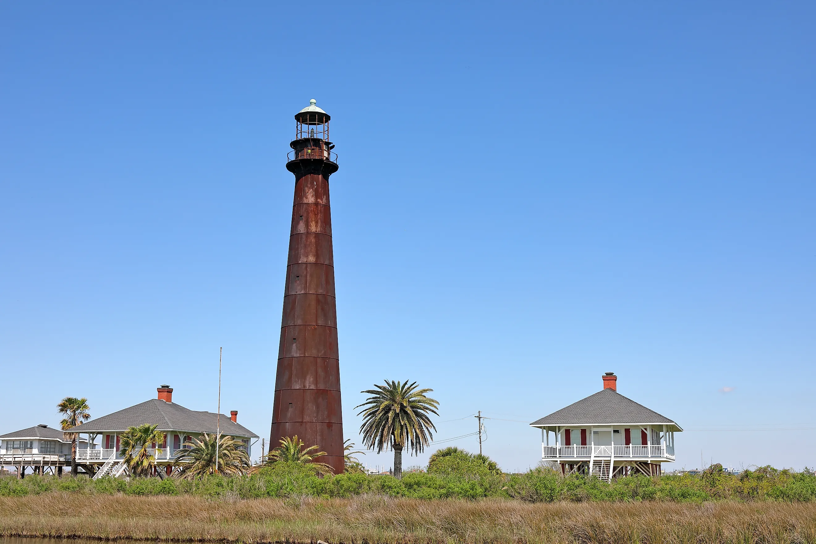
The Point Bolivar Lighthouse stands at Port Bolivar. The black and white iron tower dates to 1872 and sheltered residents through the hurricanes of 1900 and 1915. The tower has been privately owned since 1947. The public cannot enter.
SH 87 then runs 28.4 miles up the Bolivar Peninsula to High Island in Galveston County. That stretch takes about 34 minutes. Birds Houston, the conservation group formerly called Houston Audubon, protects 1,307.83 acres of the peninsula at the Bolivar Flats Shorebird Sanctuary. The group bought the last unprotected parcel in January 2026, and the site holds international status in the Western Hemisphere Shorebird Reserve Network.
High Island rests on a salt dome and rises to 38 feet. The Handbook of Texas calls that the highest point on the Gulf between Mobile and the Yucatán Peninsula. Birds Houston also manages the Smith Oaks Bird Sanctuary in town, open all year for a fee.
Where The Highway Waits For The Boat
Every road here meets the water and keeps going. The Whitehaven cable ferry takes three cars and stops at a posted hour. The Bolivar boats never stop at all. Tolls apply on the Cape Fear and the Cumberland, while the Maryland, Kentucky, and Texas crossings cost nothing. Between landings, the drives take in the gorge of the Kentucky River, the oak ridge of Bayou Pigeon, and the salt dome under High Island.