8 Great Road Trips to Take in Nevada
Nevada's roads humble anyone who thinks they've seen it all. No drive here has drawn more attention than US-50, which Life Magazine branded "The Loneliest Road in America" in 1986, warning travelers off unless they were "confident of their survival skills." Nevada tourism officials turned the insult into a slogan, and the road became a bucket-list drive. But it is only one entry point into a state built almost entirely from dramatic basin-and-range terrain. Here are eight drives that prove it.
The Extraterrestrial Highway (SR-375)

Ninety-eight miles of pavement run dead straight through the heart of Nevada's Great Basin, and for long stretches yours is the only car on it. Sagebrush valleys alternate with rugged ranges in the classic basin-and-range pattern that shapes much of the West. The road crests Hancock Summit at 5,592 feet, then drops into the vast Tikaboo and Sand Spring valleys, where the asphalt narrows to a point on the horizon. Traffic is scarce. The silence is total.
The scruffy village of Crystal Springs anchors the southern end at US 93, an oasis of trees, bushes, streams, and marshes in the desert. From there the highway climbs into the foothills of the Pahranagat Range and tops out again at Hancock Summit. Past Nellis Base and Area 51, it swings northwest and runs arrow-straight for more than 10 miles at a time. The barren hills to the north belong to the BLM's Basin and Range National Monument. Rachel is the only town you will pass, and it amounts to a gas station, a church, a handful of houses, and a famous alien-themed bar, restaurant, and motel called The Little A'Le'Inn. The route finally bends west through the Reveille Range and meets US 6 at Warm Springs, an abandoned village built around a desert oasis.
US-50, The Loneliest Road

Ely started life as a stagecoach and Pony Express station, and the moment you leave it, Highway 50 zigzags above 7,000 feet into thick pine forest. Over the miles ahead you cross a dozen mountain ranges and the wide desert basins between them, the classic Basin and Range landscape. After every summit the road runs arrow-straight across the valley floor, where 10,000-foot peaks rise cold and sudden from the flats.
Eureka, about 77 miles west of Ely, is the first real town. Austin comes 70 miles later, up a steep, twisting pass between the Toquima Range and the Simpson Park Mountains. By Fallon the emptiness eases and the spell starts to lift. One more hour delivers you to Carson City, 320 miles from where you started, and a steakhouse dinner you will have earned.
Mount Rose Highway (SR-431)

SR 431 tops out at the 8,911-foot Mount Rose Summit, the highest year-round highway pass in the Sierra Nevada, and it earns every foot. The climb starts in the ponderosa pines above Incline Village, on the shore of Lake Tahoe. Grab your last photos of the lake before the road turns north and winds 25 miles through fragrant conifers and Tahoe Meadows. At the top of the pass, the hiker-favorite Tahoe Rim Trail runs off toward jagged peaks, alpine lakes, and meadows of wildflowers.
You will pass Mt. Rose-Ski Tahoe, which sits at the highest base elevation of any resort in the Lake Tahoe region, above 8,200 feet. Just before Reno comes into view, Galena Creek Regional Park offers fishing at Marilyn's Pond and trails tracing the gentle flow of Jones and White creeks. Come winter, trade the boots for a sled or cross-country skis and grab one last taste of the Sierra. Figure 30 minutes for the drive, 45 if you take it slow.
Lamoille Canyon Scenic Byway

They call the Ruby Mountains the "Swiss Alps of Nevada," and this 12-mile dead-end road drives you straight into them. Officially National Forest Road 660, the Lamoille Canyon Scenic Byway climbs a glacier-carved valley off the high desert floor. From Elko, head roughly 22 miles southeast on State Route 227 and turn right about a mile before the town of Lamoille. Almost at once, the open sagebrush plains give way to the Rubies' sharply sculpted skyline.
The lower miles wind gently beside Lamoille Creek through stands of pine and aspen. Then the canyon narrows, granite cliffs close in, and waterfalls spill from side canyons the Ice Age glaciers carved. The pavement quits at Road's End, 8,800 feet up, where a trailhead leads into the heart of the Ruby Mountains Wilderness. It is a short drive, and it packs in as much alpine scenery as anywhere in Nevada.
Angel Lake Scenic Byway

The nickname alone, the "Stairway to Heaven," tells you what SR 231 is after. In 11.7 miles from Interstate 80 at Wells, the byway climbs into the East Humboldt Range and dead-ends at Angel Lake, an alpine cirque ringed by cloud-grazing cliffs. Greys Peak rises to the west. A cluster of pinnacles called Chimney Rock spikes up to the south.
The vegetation shifts as fast as the elevation. Sagebrush and piñon pine at the bottom give way to mountain mahogany, then aspen and limber pine near the top. Snow closes the road from mid-October through May, so this is strictly a summer-into-early-fall drive, and no services exist on the climb or at the lake. Fill the tank and pack the cooler in Wells before you start.
Pyramid Lake Scenic Byway

Leave Sparks, once a Southern Pacific Railroad yard, and SR 445 climbs north through the sagebrush of the Virginia Mountains to Mullen Pass. Then the land drops away, and the deep turquoise of Pyramid Lake appears all at once, its brilliance sharpened by the volcanic hills and desert emptiness around it. At Sutcliffe, double back to State Route 446, which hugs the lake's western shore down to Nixon. The Kooyooe Panuadu Overlook lays out the whole scene, the water, the tufa rock formations, and the ringing mountains. Offshore, the Anaho Island Wildlife Refuge shelters one of North America's largest breeding colonies of American white pelicans, visible from the right pullout.
The Wheeler Peak Scenic Drive

Twelve miles, 3,000 feet of climb. The Wheeler Peak Scenic Drive gains altitude fast, starting near the Lehman Caves Visitor Center around 7,000 feet in an ocean of low-lying sagebrush. The pines grow taller as you rise, then thin into scrappy mountain mahogany. By 9,000 feet you are in a forest of mixed conifers, white fir, Douglas fir, and ponderosa pine.
By the eleventh mile you are cruising at 10,000 feet, in country that feels more Rocky Mountain alpine than Nevada desert, where white-barked aspen take over. Each switchback widens the view across Snake Valley and the rugged South Snake Range, until the road ends at Wheeler Peak Campground, above 10,000 feet, beneath the soaring 13,065-foot Wheeler Peak, Nevada's second-highest summit. The road is narrow and winding, so the 35 mph speed limit is strictly enforced.
The Valley of Fire Scenic Byway

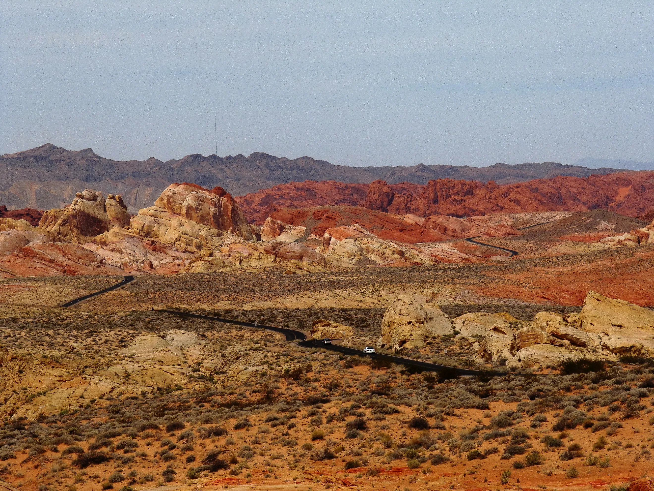
Eleven miles of road cut through sandstone 150 million years old, sculpted into fiery red cliffs, domes, and arches. From the park's west entrance off Interstate 15, the byway climbs into the heart of the Aztec Sandstone, and every bend turns up rock streaked crimson, pink, and cream.
Stop at the Beehives, whose cross-bedded sandstone stacks up like towering piles of pancakes, then climb the short staircase at Atlatl Rock to a wall of remarkably preserved petroglyphs. A campground loop passes Arch Rock, a graceful sandstone span that wind and water cut over millions of years. Farther east, branch into Petroglyph Canyon for rock carvings left by early Indigenous peoples, or push on to Elephant Rock, the most photographed formation in the park, right before the east entrance.
The Two To Drive First
Nevada gives you no shortage of ways to hit the road. If you only have time for two, make them the classics. Take the Loneliest Road for its sheer, unfiltered emptiness, mountain pass after mountain pass, valley after valley, with just enough ghost towns and hot springs to keep it interesting. And do not underrate the Valley of Fire, an 11-mile stretch of 150-million-year-old sandstone glowing crimson and pink, easily done in an afternoon out of Las Vegas. Between them, they capture what makes this state worth driving, distance and drama, often on the same trip.