7 Most Scenic Drives in New South Wales
As far as scenery goes, New South Wales is essentially a world unto itself, with scenery ranging from snow-capped mountains to lush rainforests and scorching deserts. Such a state is uniquely well-positioned for memorable road trips, including the Rainforest Way and the Grand Pacific Drive. Sorted by length from shortest to longest, the following trips provide a particularly excellent cross-section of the kinds of natural and cultural sites one can expect when traveling through New South Wales by road.
Southern Tablelands Drive

The Southern Tablelands Drive, clocking in at a breezy 74 kilometres, winds through the heart of the Southern Tablelands, offering a relaxed drive through rolling farmland and historic towns. Starting in the historic wool-producing town of Goulburn, home of the famous "Big Merino" statue, the drive heads eastwards along Mountain Ash Road, passing heritage homesteads, rolling paddocks, and oak-lined streets that reflect the region’s pastoral legacy. The first town of note is Bungonia, gateway to Bungonia National Park. The drive then turns northwards along Jerrara Road to hook up with the Hume Highway at Marulan, an historic town that is a popular antiquing destination. The route then continues east along Highland Way to the town of Tallong, the route's terminus and an access point to hiking destinations such as Badgery's Lookout and Long Point.
Kosciuszko Alpine Way

The 171-kilometre-long Kosciuszko Alpine Way follows the rural Alpine Way through the dizzying heights of the Snowy Mountains in the shadow of Mount Kosciuszko. In summer, the hillsides are green and wildflower-speckled, while winter brings snow-dusted ridges and crisp air. The drive begins in the town of Cooma, the "Gateway to the Snowy Mountains" and home to the Snowy Hydro Discovery Centre. The route heads west along the Snowy Mountains Highway for about seven kilometres before veering south along Kosciuszko Road through Berridale to Jindabyne, one of the state's premier ski resort towns. After Jindabyne, the drive climbs into the heart of Kosciuszko National Park before cresting the Great Dividing Range at Dead Horse Gap. From Tom Groggin, the road turns sharply north along the New South Wales-Victoria state border through a series of valleys all the way to the route's terminus at Khancoban. Along the way, there are numerous opportunities for bushwalking, fishing, and mountain biking, as well as picnic spots like Geehi Flats beside the Swampy Plain River.
Great Pacific Drive

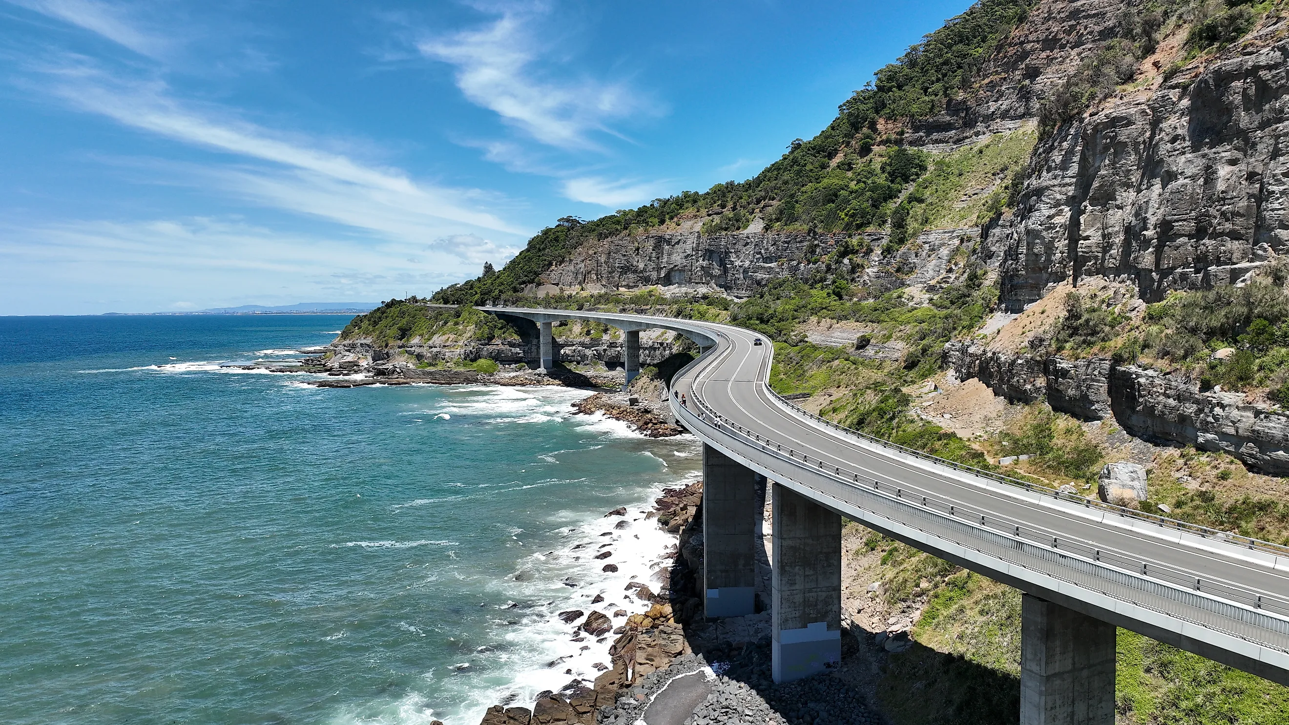
The Great Pacific Drive is one of Australia’s most celebrated coastal road trips, stretching roughly 200 kilometres from Sydney south into the Shoalhaven region. Much of the route follows scenic sections of the Princes Highway and connecting coastal roads, hugging rugged headlands and ocean views. Starting in Sydney, the route heads south along the A1 before exiting onto Sir Bertram Stevens Drive, which winds through Royal National Park. The route continues south along the coast, passing many famous beaches and crossing the iconic Sea Cliff Bridge before ending in the university town of Wollongong, home to the Wollongong Art Gallery, with nearby Berkeley hosting the Nan Tien Temple. The drive continues south along the Princes Highway, crossing Lake Illawarra and passing through the Shellharbour area, home of the HARS Aviation Museum and the surfers' mecca that is Killalea Beach. The route continues south along the Illawarra region through the town of Kiama, home of the Kiama Blowhole, eventually crossing the Shoalhaven River between Bomaderry and Nowra and splitting from the Princes Highway at Falls Creek to head east towards Jervis Bay. The route passes through sheltered bays and green hinterland before arriving at its terminus in the small bayside town of Huskisson, which offers plenty of opportunities for activities such as fishing, surfing, swimming, diving, kayaking, and dolphin watching.
Waterfall Way

Waterfall Way is a scenic country road spanning about 212 kilometres between Coffs Harbour on the North Coast and Armidale inland. This drive links the Pacific Highway with the New England Highway, cutting through lush forest, deep river valleys and a string of national parks. Leaving Coffs Harbour, which hosts the Big Banana Fun Park and the Muttonbird Island Nature Reserve, the route heads south along the Pacific Highway down the Mid North Coast for about 22 km. It then splits off at Raleigh, heading west alongside the Bellinger River. Along the way, the route climbs into the Great Dividing Range and traverses the dramatic Dorrigo escarpment, affording panoramic views at places like Dorrigo National Park. The first major waterfall, Crystal Shower Falls, is just outside Dorrigo, a small mountain near the Dorrigo Rainforest Centre. The route continues west along the Dorrigo Plateau, passing many natural attractions, including Ebor Falls, New England National Park, and Cathedral Rock National Park, before reaching Wollomombi, notable for its Wollomombi Falls. It's about another 40 kilometres west before the route terminates at the upland town of Armidale, home of the New England Regional Art Museum.
Greater Blue Mountains Drive

The Greater Blue Mountains Drive, an expansive scenic loop, explores much of the Blue Mountains World Heritage Area. Unlike the other routes presented here, the Greater Blue Mountains Drive is an open-leg itinerary. It comprises a series of attractions that one can explore in any manner they see fit. For simplicity, this entry presents a sample itinerary covering about 250 kilometres. As a whole, the journey ties together spectacular lookouts, deep valleys, and towering sandstone plateaus. Starting from Sydney, the drive heads west along the Western Motorway through the suburbs to the entrance of the Blue Mountains near Emu Plains, where the Western Motorway yields to the Great Western Highway and the flat Cumberland Plain gives way to eucalyptus-cloaked ridges and cliff-lined gorges. The first stops of note are a trio of towns immediately adjacent to one another: Wentworth Ridge, Leura, and Katoomba, which host attractions such as Wentworth Falls, Everglades House and Gardens, the Three Sisters, and Scenic World. A short distance down the road is the artists' colony of Blackheath, where attractions include the Blue Mountains Heritage Centre and Evans Lookout.
At Mount Victoria, the route leaves the Great Western Highway and heads north along Darling Causeway to Bell, where it takes a sharp eastward turn along Bells Line of Road. This road through the Bell Range of the Blue Mountains is quieter and less traveled than the Great Western Highway, but no less scenic, with the town of Mount Tomah hosting the massive Blue Mountains Botanic Garden. The next notable town is Bilpin, the "Land of the Mountain Apple," where apple orchards abound, and many local establishments sell fresh produce, apple juice, and a variety of ciders. At Bellbird Hill, the road descends back into the Sydney suburbs, then continues to central Sydney along Richmond Road and the Westlink M7. The world heritage landscape reveals itself around every bend, with forests, waterfalls, and wildlife sightings making this one of the most multifarious road trips in New South Wales.
Fossickers Way

Fossickers Way is a 380-kilometre-long countryside route composed of several linked country roads, primarily designated as Routes B95 and B76, that threads through the Northern Tablelands. Named for the region’s rich deposits of gold and gemstones such as sapphires and jasper, the drive invites exploration of quaint towns with their historic pubs, local museums, and fossicking sites. Starting from the Gold Rush-era town of Nundle, home of the Nundle Woollen Mill and the historic Peel Inn, Fossickers Way heads north along Nundle Road to Tamworth, the traditional home of Australian country music and the site of the 12-metre-tall Golden Guitar, as well as the annual Tamworth Country Music Festival. After Tamworth, the route continues north along the B95 past Manilla, the closest town to the popular paragliding site at Mount Borah. It then enters the characterful town of Barraba, the closest decent-sized settlement to Mount Kaputar National Park. Continuing in the same direction through Bingara, home of the historic Roxy Theatre, as far as the town of Warialda, the route eventually turns sharply eastwards along the Gwydir Highway. The next notable settlement is the renowned "Sapphire City" of Inverell, home of the Inverell Pioneer Village and a convenient base for visiting the Billabong Blue Sapphire Fossicking Park about 22 kilometres away. One final push eastwards brings the route to its terminus at Glen Innes, a town with a strong Scottish influence and home of the Australian Standing Stones and the Australian Celtic Festival.
Rainforest Way

Defined by lush subtropical forests, volcanic landscapes, and heritage towns, the Rainforest Way is a series of loops through the World Heritage-listed Gondwana Rainforests of the northern New South Wales and southern Queensland borderlands. Like the Greater Blue Mountains Drive, the Rainforest Way is not one singular itinerary but is instead a list of attractions that one can visit in any order; as such, the route defined here will be a roughly 420-kilometre-long example route starting and ending in Byron Bay, home of the Cape Byron Headland and Lighthouse. The route strikes northwest to Mullumbimby, hosting the Brunswick Valley Historical Society Inc Museum And Park, before heading along the Tweed Valley Way to the intriguing Art Deco town of Murwillumbah, home of the Tweed Regional Gallery and Margaret Olley Art Centre. The route then turns southwest through the Tweed River Valley through Uki, a town at the foot of the famous Wollumbin (formerly Mount Warning), before briefly curving back southeast through Mebbin National Park to reach the town of Nimbin, the counterculture capital of Australia, which plays host to Djanbung Gardens and Nimbin Rocks. After Nimbin, the road heads west again before reaching Kyogle, the gateway to Border Ranges National Park to the north. It then heads northwest along Summerland Way for a good hundred kilometres or so; the setting here is verdant and wild, with ancient trees, fern-lined gullies, and abundant birdlife.
Eventually, the route reaches the small village of Urbenville, the closest settlement to Tooloom National Park, before turning sharply south along Clarence Way for another hundred kilometres or so to the village of Tabulam. From there, the route heads east along Bruxner Highway past Mallanganee National Park to the town of Casino, the "Beef Capital of Australia," the site of the Casino Beef Week in May each year. After Casino, the Bruxner Highway continues to the regional centre of Lismore, home of the Lismore Regional Gallery; after Lismore, the route diverges due north along Dunoon Road to allow a visit to Nightcap National Park, which boasts natural beauty spots such as the Rocky Creek Dam and Minyon Falls Lookout. A zigzagging scramble to the southeast along various small country roads takes prospective motorists to the town of Newrybar, with the renowned Gaia Retreat & Spa, formerly co-owned by the late Olivia Newton-John, nearby in Brooklet. A sharp turn back to the north brings the route to the nearby town of Bangalow, home of the historic Bangalow Hotel, and a final turn to the northeast brings the route back to where it started in Byron Bay.
From the gentle farmland of the Southern Tablelands to the lush, looping hinterlands of the Rainforest Way, New South Wales reveals itself as a state of remarkable contrast and depth when explored by road. Each journey offers its own distinct character, whether defined by alpine peaks, coastal drama, cascading waterfalls, or historic country towns. Yet, all share a common thread of accessibility and wide variety. Taken together, these routes highlight not only the state's geographic diversity but also its cultural texture, where natural beauty and local heritage intertwine at every bend. For sojourners willing to venture beyond the dull comfort of the suburbs, these drives offer an ever-changing, scintillating tapestry of experiences that capture the essence of New South Wales in motion.