6 Most Scenic Drives In Washington
Washington State has many attractive landscapes ideal for exploring by car. Whether you’re interested in seeing the dramatic glacier-capped peaks of the Cascade Range or the rugged shorelines of Puget Sound, this Pacific state has been a must-visit road trip destination since its first designated scenic route opened along Chuckanut Drive in 1916. Taming once impassable mountain terrain to build routes like the North Cascades Highway opened up whole new worlds of scenery to travelers. Connected by a network of highways from cities like Seattle, the state’s mountain ranges, shorelines, and quaint small towns are now within easy reach. Here are a few of the best scenic drives in Washington to add to your travel plans.
North Cascades Highway

Plans for the North Cascades Highway were first announced in the 1890s, but it wasn’t until 1972 that this magnificent mountain route was completed. Crossing the Cascade Range at two passes and winding between peaks as high as 9,000 feet, this 75-mile drive along State Route 20 begins in Marblemount, a small settlement on the Skagit River that serves as the last supply point.
From Marblemount, the road follows the Skagit through increasingly narrow canyon walls into North Cascades National Park. Gorge Creek Falls appears at a pullout roughly 20 miles in, and a short walk leads to views of the cascade dropping through a rocky chute. The turquoise waters of Diablo Lake Overlook are next, so have your camera ready.
The highway then climbs up to Rainy Pass at 4,855 feet, where a paved trail leads to Rainy Lake. Washington Pass is next. Here, at 5,477 feet, an observation platform has views of Liberty Bell Mountain and the Early Winters Spires, a dramatic wall of granite towers that rival anything in the American West.

The descent into Methow Valley brings a complete change of landscape. Dry pine forests replace the dense fir and cedar of the western slopes, and the light takes on a different quality, brighter and sharper than the filtered gray of the Puget Sound side. The highway drops into Mazama, then continues to Winthrop, a small town with an Old West theme that’s fun to explore.
When To Go: This route closes entirely from November through May, when snow makes it impassable. Summer weekends bring moderate traffic, but the road never feels crowded, given its length and the number of pullouts available.
Chuckanut Drive

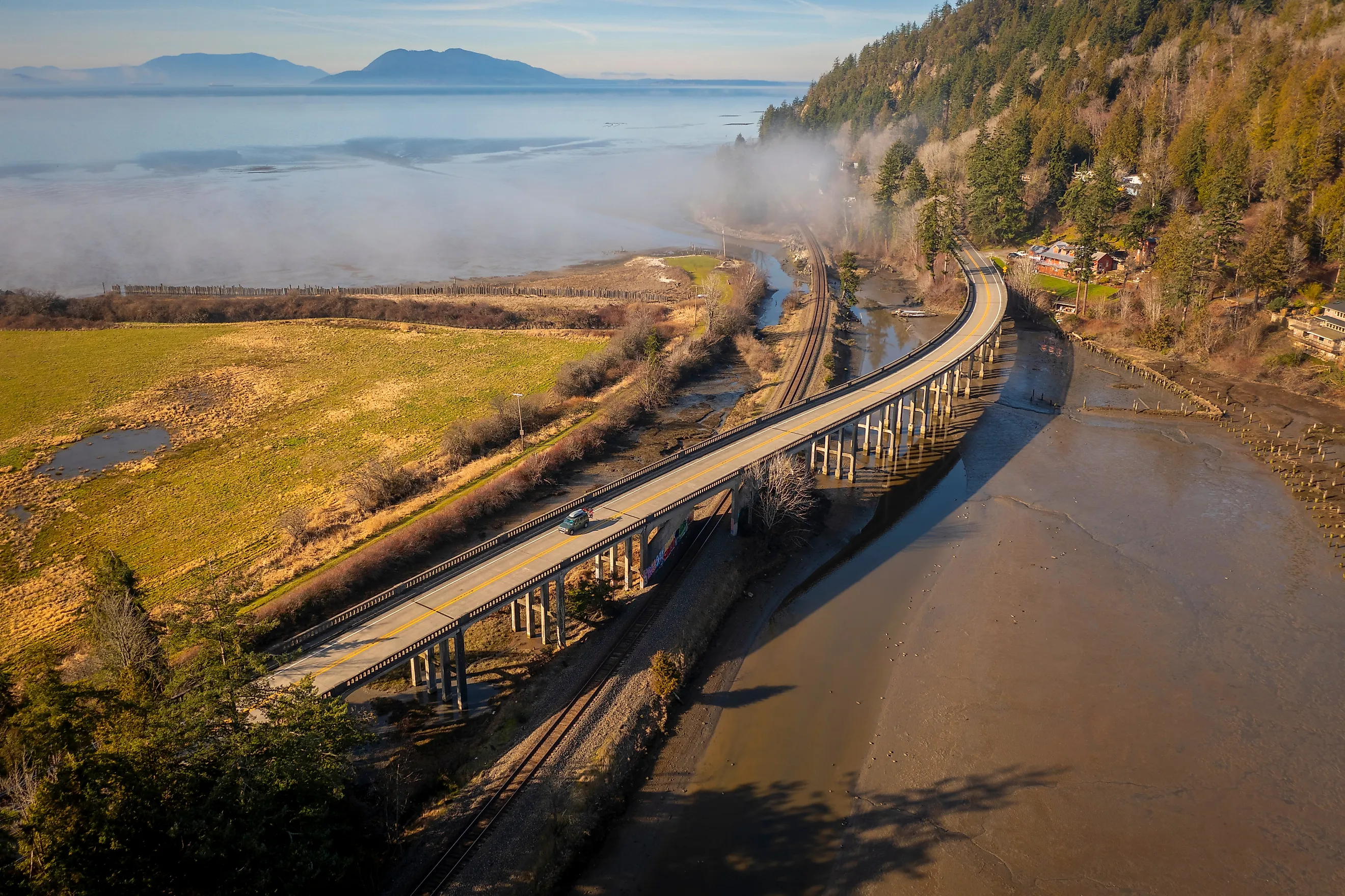
Washington's oldest scenic byway, Chuckanut Drive, opened in 1916 as a link between Bellingham and points south. State Route 11 covers 21 miles between Burlington and Bellingham, a one-hour drive that packs a surprising amount of coastal scenery into its short length.
The drive begins in Burlington, an agricultural town in the Skagit Valley that’s known for its tulip fields, which bloom each April. Heading north, the road leaves the farmland behind and begins climbing into the Chuckanut Mountains, a small coastal range that rises from the shore of Samish Bay. Within just a few miles, you’ll find yourself in the hillside above the water, with Puget Sound visible through gaps in the trees that line the route.

Larrabee State Park, about midway along the drive, provides the best opportunity to reach the water. The park occupies both sides of the road, with trails leading down to rocky beaches on Samish Bay and uphill to Fragrance Lake. If you’ve got time, Chuckanut Manor Seafood & Grill, north of the park, is popular for its ocean views. The final stretch into Bellingham passes through Fairhaven, a historic district that predates Bellingham and retains its original Victorian-era street grid and commercial buildings.
When To Go: Chuckanut Drive is passable year-round, though winter storms occasionally bring closures. Spring offers the combination of tulip season and migrating birds. Autumn means fewer visitors and reliable weather before the winter rains arrive.
Chinook Pass Scenic Byway

Mount Rainier dominates Washington’s landscape and is even visible from Seattle. Several roads approach the mountain, but none match the experience of State Route 410 over Chinook Pass. This National Scenic Byway covers 85 miles between Enumclaw and Naches, a journey of nearly three hours that climbs through subalpine meadows, crosses the Cascade crest at 5,432 feet, and then descends on the eastern side.
The drive begins in Enumclaw, a former logging town, then enters the Mount Baker-Snoqualmie National Forest before climbing along the White River valley. Federation Forest State Park, about 17 miles from Enumclaw, is worth a stop. Check out the Catherine Montgomery Interpretive Center with its exhibits about the region’s unique forest ecosystems.

The scenic byway continues east toward Chinook Pass, with Tipsoo Lake being one of the most accessible alpine meadow experiences in the state. In July and early August, wildflowers carpet the slopes around this small lake while Mount Rainier fills the western horizon. The pass itself marks the boundary between Mount Rainier National Park and the Wenatchee National Forest, and the landscape shifts as the road drops through Morse Creek and passes campgrounds and trailheads before reaching the town of Naches and the Yakima Valley.
When To Go: The pass is open from late May through November, depending on snowfall. Even in summer, morning temperatures at Tipsoo Lake can approach freezing, and afternoon thunderstorms are common in July and August
Whidbey Island Scenic Isle Way
One of the longest islands in the country, Whidbey Island Scenic Isle Way stretches for nearly 60 miles through northern Puget Sound and makes for a superb scenic drive destination. Here, State Routes 525 and 20 cover the 45 miles between the ferry landing at Clinton and Deception Pass at the island's northern tip, a drive of close to two hours.

Here, it’s all about farmland, historic waterfront towns, and the coastal bluffs overlooking Admiralty Inlet and the Strait of Juan de Fuca. Starting at the Clinton ferry terminal (it connects to Mukilteo on the mainland, a crossing of just 20 minutes), the road passes through Langley, an arts-oriented village perched on a bluff above Saratoga Passage. It’s worth stopping for its pleasant little downtown and the views across the water to Camano Island.
Continuing north, the route enters Ebey's Landing National Historical Reserve near the town of Coupeville. The island's most significant historic and scenic area, Ebey's Landing, has been farmed continuously since the 1850s, making it one of the oldest agricultural areas in Washington, while Coupeville is a quaint heritage town with a working wharf. Fort Casey State Park features restored gun batteries from the early 1900s and views across Admiralty Inlet to Port Townsend and the Admiralty Head Lighthouse, built in 1903.

The drive ends at Deception Pass, the narrow channel separating Whidbey Island from Fidalgo Island. Stop for the views of the bridge spanning the pass (it was completed in 1935).
When To Go: While the drive can be completed year-round, summer brings the most visitors, particularly to Deception Pass. Shoulder seasons are quieter and generally have good weather.
Hood Canal Scenic Drive

Following a fjord in Puget Sound, Hood Canal Scenic Drive’s US Highway 101 route extends 40 miles between Quilcene and Hoodsport. A drive of 90 minutes, the water on one side and steep Olympic Mountains on the other, adds to the appeal.
Located on Quilcene Bay near the northern end of Hood Canal, Quilcene has been a major oyster producer for more than a century. Its cold, clean water produces shellfish prized by restaurants throughout the Pacific Northwest, and several oyster farms along this stretch of highway are open to the public.

Heading south, the road passes through the hamlet of Brinnon with views across the water to the forested slopes of the Kitsap Peninsula. Dosewallips State Park, about 15 miles south of Quilcene, provides beach access and serves as a trailhead for routes leading into Olympic National Park. Hoodsport, the southern end of the drive, is a great base for visitors to the Staircase area of Olympic National Park and the Lake Cushman recreation area.
When To Go: Accessible year-round, late summer and early fall bring the clearest skies and the best mountain views, with snow remaining on the higher peaks even in August.
Columbia River Gorge

The Columbia River Gorge divides Washington from Oregon along an 80-mile corridor where the river cuts through the Cascade Range. While most visitors drive the Historic Columbia River Highway on the Oregon side, State Route 14 on the Washington side extends for 50 miles between Stevenson and Maryhill, and features equally dramatic scenery.
Stevenson, at the western end of the route, is where you’ll find the Columbia Gorge Interpretive Center; it’s well worth a stop to get a better understanding of the region. Head east and the road hugs the riverbank, passing beneath sheer basalt formations like Beacon Rock, an 848-foot monolith and one of the largest freestanding rocks in North America. A trail built in 1918 switchbacks to the summit with the aid of handrails and catwalks bolted to the rock face.

The mid-section of the drive passes through the heart of the gorge's wind corridor, where the river funnels air between the Cascades and the drier interior. This phenomenon has made the area popular among windsurfers and kiteboarders. East of here, the landscape opens up to grasslands, and the river widens as it enters the drier Columbia Plateau.
Maryhill is where your journey ends and is a must-stop for the Maryhill Museum of Art. Set in a magnificent mansion built in the 1900s, the spectacular views over the Columbia River alone make it a great place to stop. You’ll also want to check out the nearby full-scale replica of Stonehenge.

When To Go: Open year-round, winter brings occasional ice and snow at the eastern end. Wind is a constant and can be a challenge for high-profile vehicles like RVs. Spring and fall are near-perfect, with wildflower displays in April and golden light in October.
A State Full of Scenic Drives
Washington is definitely a state where you’ll want to ditch the main highways and take the road less traveled. Whether you’re looking for a scenic drive you can do in under two hours, or something that’ll fill an entire day, these lovely roads were built with scenery in mind and deliver some of the most memorable road trip experiences in America.