6 Most Scenic Drives in Hawaii
Travelers looking for drives through lush mountains or past volcanic landscapes should look no further than these six routes in Hawaii. On Kauai, Kuhio Highway winds through tropical, tree-lined north-shore scenery. On the Big Island and Oahu, the "Red Road" passes near the recent lava flows, while the Pali Highway offers a nearby detour to a towering waterfall. Whether you are going to Kauai, the Big Island, or Oʻahu, these six scenic drives show how much variety Hawaii has to offer from behind the wheel.
Kuhio Highway

Kuhio Highway, signed as Routes 56 and 560, runs from Lihu'e to Keʻe Beach. Start the drive from Lihu'e and follow the road, trailing alongside Kauai's eastern and northern shores, to enjoy the full Kuhio Highway experience. Beginning as a coastal highway, with the shore on one side and eucalyptus trees on the other, the route becomes even more lush as you approach Hanalei.
At Hanalei, the road crosses the one-lane Hanalei Bridge over the Hanalei River, running approximately 16 miles from Mount Wai'ale'ale to the Pacific Ocean. Passers-by will be treated to views of the strikingly clear river, and on good-weather days, kayakers on the river and sea turtles near the river mouth. Continuing north, visitors will find themselves enveloped in lush scenery, with tropical and native trees.
Those interested in stopping to enjoy the breeze will have their pick of many scenic outlooks, including Lumaha'i Beach or Wainiha Beach Park, a few miles past Hanalei Bridge. Alternatively, continue driving northwest through the tropical forest until you reach one of the final two publicly accessible landmarks, Maniniholo Dry Cave or the Kalalau Trail, stretching 11 miles along the Na Pali Coast. Whether you decide to go cave exploring, hiking, or reserve access to relax at Ke'e Beach, Kuhio Highway remains a memorable drive. Or, to head home, make a U-turn on the highway and go southbound to enjoy the drive one more time.
Pali Highway (Route 61)

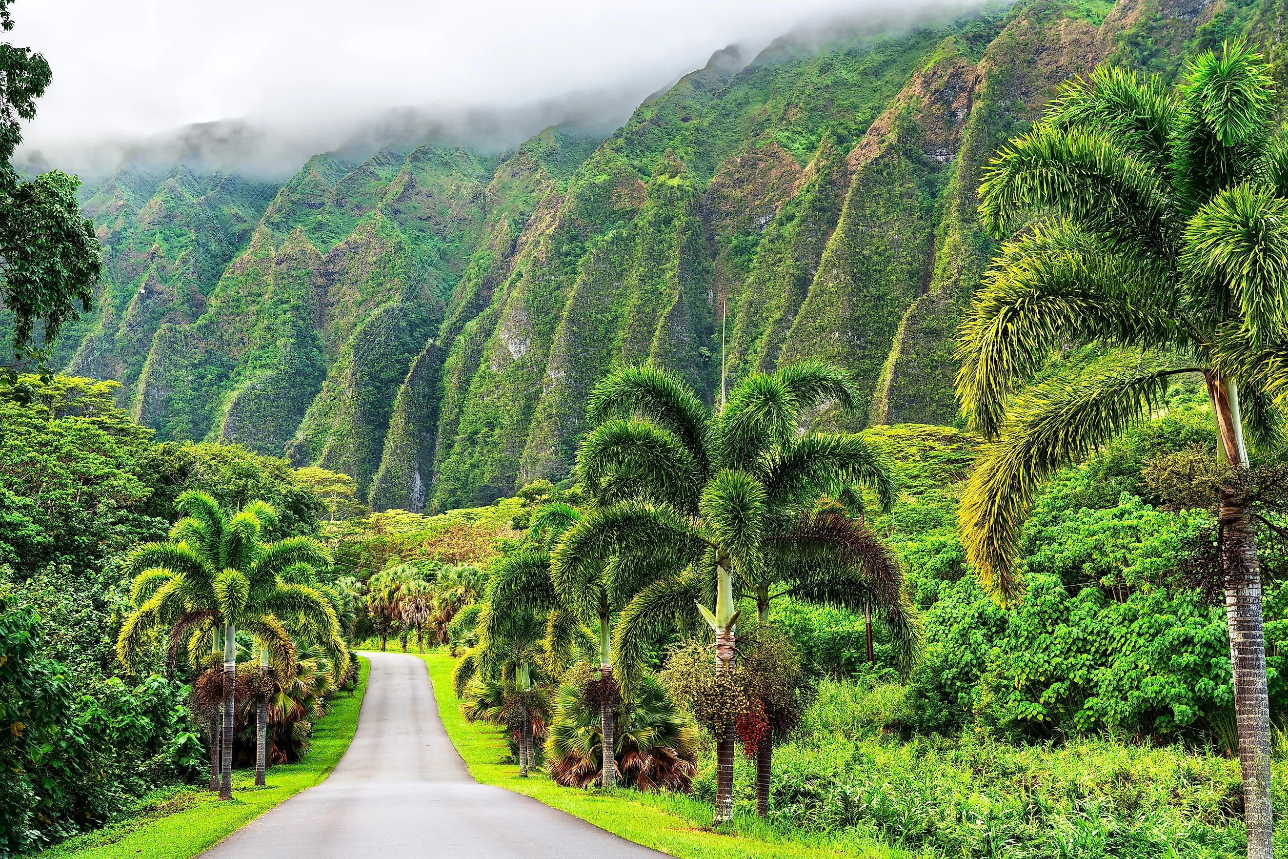
Pali Highway connects Honolulu to windward Oʻahu, including Kailua and Kaneohe. From downtown Honolulu, drivers can quickly connect to the Pali Highway, going northbound. Despite being less than eleven miles long, the Pali Highway is a rewarding drive through lush mountain scenery. Road trippers will have plenty of time to take pictures of the dense forestry in between the Nu'uanu Pali Tunnels, a safety precaution that has now become an iconic landmark along the highway.
Alternatively, travelers wanting to skip the manmade tunnels for "tree tunnels" may be interested in taking a detour onto Nu'uanu Pali Drive. This path can be reached by taking an exit off the main highway, labeled "Nuʻuanu Pali Drive," near the corner of Nuʻuanu Pali Drive and Pali Highway. This narrow, winding road is characterized by towering, tunnel-like canopy tree formations and a mysterious history. Drivers passing through experience both shade and intrigue as they drive along one of Oahu's most secluded, tree-lined roads. Due to the heavy forestry on both sides of the road, it is recommended to take the Nu'uanu Pali Drive during the day for the best visibility. At the end of Nu'uanu Pali Drive is the trailhead for Lulumahu Falls, a two-hour round-trip trail perfect for novice hikers looking to bask in bamboo forests and a refreshing waterfall.
Both the Nu'uanu Pali Drive, along with the main Pali Highway route, lead to the Nu'uanu Pali Lookout. Visitors here can enjoy a cliffside viewing area with panoramic views of the northeastern Oahu coast, lush mountains, and Ko'olau cliffs.
Kohala Mountain Road

The approximately 19-mile ride along Kohala Mountain Road on Hawaii's Big Island is a steady climb up the Kohala Mountains, with views that make it well worth your time. Centered around the Big Island's oldest volcano, the drive begins from Waimea, the southernmost point of Kohala Mountain Road. Driving north, the road offers views of green mountain landscapes, rolling hills, and steep cliffs. Pastures are also common along the road, offering a unique opportunity to see cows grazing on fertile land.
Along the way, there are many must-see pullouts, including the Kohala Mountain Scenic Lookout Point, which offers panoramic views from Waimea to Kailua. If you're passing through in the evening, this makes for an ideal spot to watch the sunset. As you continue further north, lush landscapes will transform into forest-like environments before you reach the mountain peak and start the descent to Hawi, the northern endpoint of the road. Hawi is a former sugar industry hub now best known for its coastal oceanscapes, characterized by vibrant blue waters and green cliffsides.
"Red Road" (Highway 137)

Nicknamed "Red Road" for its distinctive red cinder pavement along the northern end of the road, Highway 137 runs directly next to the shoreline of the Big Island's southeastern coast. On the inland side, the highway sits near Kilauea, the most active volcano on Earth. Kick off your trip along the "rocky" road from Pahoa, taking Highway 130 south before promptly turning left onto Highway 137.
Drivers will be treated to views of palm-lined cliffsides and vibrant green mountainscapes, all while in the vicinity of unique lava formations. Parts of the road are even built directly atop remnants of a 2018 lava overflow from the nearby Kilauea, which has transformed the originally red cinder pavement into a reconstructed roadway surrounded by black asphalt. Travelers wanting to get up close with the lava may be interested in taking a detour to Mackenzie State Park to see unique lava-tube-like cave formations. Alternatively, continue straight south to Kaimu Beach Eco-Path for the opportunity to walk over a lava field formed by the remnants of the 1990 Kilauea eruption. The trail leads to a newer black-sand shoreline, where replanted palm trees emerge among the many lava rocks. This park is located less than a mile from Kalapana, the southern endpoint of the scenic byway.
Hamakua Coast

Waterfall enthusiasts will have a wonderful time traversing this 45-mile drive along the Hamakua Coast. Beginning in Hilo and ending at the Waipio Valley Lookout, the Hamakua Coast scenic drive takes you through a lush rainforest, past canyons offering grand views of the Pacific Ocean, and near waterfalls. One such waterfall is the 442-foot-tall Akaka Falls, approximately a 15-mile drive north of Hilo, making a great, brief stopping point for travelers interested in seeing a waterfall up close.
Continuing north along the Big Island's northeastern shore, drivers can enjoy the coastal breeze and long ocean views. The dramatic seascapes following the road make for picture-perfect photography opportunities for the remainder of the drive until you reach the Waipio Valley Lookout, the culmination and endpoint of the Hamakua Coast Scenic Drive.
This lookout is a place of both incredible scenery and historical significance. King Kamehameha I, the first ruler of the Kingdom of Hawaii, was raised in Waipio Valley, transforming the region into an ancient Hawaiian cultural and political hub. Today, the lookout offers panoramic views of Waipiʻo Valley and the adjacent coast, allowing tourists to enjoy both the region's natural beauty and its deep history.
Highway H-3

Travelers looking for a quick scenic drive through verdant mountain landscapes should look no further than Highway H-3. Officially known as the John A. Burns Freeway, Highway H-3 spans approximately 15.3 miles, connecting Halawa with Marine Corps Base Hawaii near Kaneohe, with exits toward Kaneohe and Kailua. From Halawa, hop onto the H-3 from highway H-1, Route 78, or Highway 201. Highway H-3 crosses the Koʻolau Range on several viaducts, with steep green ridges rising sharply above the highway.
Along with those mountain views, enjoy the opportunity to drive through the iconic Tetsuo Harano Tunnels, a unique brutalist-style development that stands out from its lush green surroundings. These are also the longest tunnels in the entire Aloha State, measuring 5,165 and 4,890 feet long. Nearing the northeastern end of the highway, drivers will also be able to spot distant views of Kaneohe Bay, a lagoon known for its clear, shallow waters and numerous coral formations.
Hawaii’s Most Memorable Scenic Roads
Hawaii is home to some of the most unique topography in the entire United States. From tree-lined roads storied with haunted histories to highways alongside volcanoes and through steep mountains, the Aloha State offers visitors no limit to the variety of spectacular drives. Whether you're a tourist or a local, don't miss out on these six one-of-a-kind drives during your trip to The Islands.