6 Best Natural Wonders To Visit In California This Year
Natural beauty abounds in California. With the desertscapes near the Mexican border and the lush woodlands of the Pacific Northwest, the state hosts what may be the most diverse set of environments in any single state in the country. The Yosemite Valley is famed internationally for its breathtaking landscape, featuring towering rock formations and impressive waterfalls. Death Valley, the lowest point in North America, is known for its scorching temperatures and its raw, otherworldly desert landscape. Lake Tahoe is the country's second deepest lake and is known for its crystal-clear waters with visibility of more than 60 feet. Here are 6 natural wonders of California that any resident or visitor in California ought to see to be believed in 2026.
Yosemite Valley

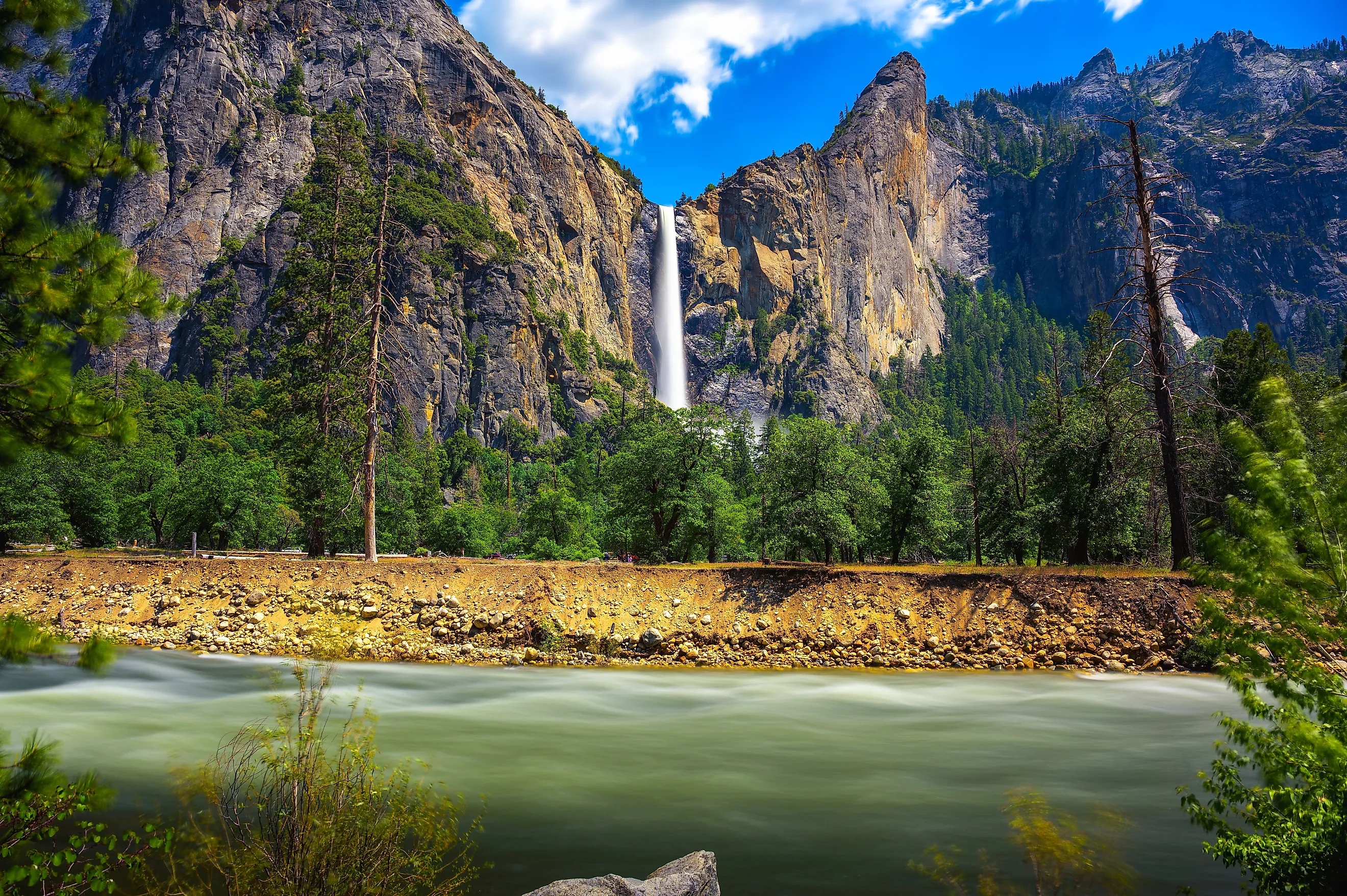
Yosemite Valley, sitting in none other than the Yosemite National Park, remains one of the most recognizable natural wonders in the world, let alone California. Here, lofty rock formations like El Capitan and Half Dome rise abruptly in almost all directions from the forested valley floor, all shaped by glacial movement over millions of years.
Seasonal runoff feeds a series of equally impressive waterfalls such as Yosemite Falls, which ranks among the tallest on the continent with its dizzying 2,425-foot drop. Moreover, the Merced River cuts through the lower portions of the valley, giving way to meadow ecosystems that contrast sharply with the usually bare cliff faces surrounding them.

Spring and early summer typically see the heaviest water flow, while autumn brings clearer sightlines, fewer crowds, and cooler temperatures that may be more favorable for longer hikes. With that, a huge network of well-maintained trails and viewpoints provides access for a variety of fitness levels to appreciate without requiring technical climbing, allowing visitors to experience this national park's large-scale geological features up close and within a relatively compact area.
Just be aware that Yosemite, given its popularity, can also be very crowded at times. The best way to avoid that is to go on a backcountry hike or head out during the quieter weeks of late October/November or even wintertime.
Death Valley

For a much more stark valley experience, Death Valley National Park holds the record for the lowest land elevation in North America, creating the conditions for local temperatures to often soar past 120°F. In fact, the park recorded134°F in 1913, the highest air temperature ever measured.
In total, the valley spans about 140 miles, bordered by mountain ranges that block moisture and create this extreme aridity, with average annual rainfall of only about 2 inches. At Badwater Basin, which sits 282 feet below sea level, you'll find an arid landscape almost completely devoid of life, but one that is oddly beautiful too. Other large salt flats have formed as evaporated groundwater leaves behind mineral deposits, giving the region an even more otherworldly, almost ghostly feel. Nearby, another point of interest is the Mesquite Flat Sand Dunes, which rise up to 185 feet and often shift with prevailing winds.

Despite the truly extreme conditions, specialized plant and animal species do actually persist here, particularly during brief spring bloom periods following rare winter rains. For you, however, without proper hydration and sun protection, things can quickly get deadly, especially during midday while out on the trail.
Lassen Volcanic National Park

The geothermal field at Lassen Volcanic National Park is among the few places in the United States where all four major volcanic features occur: plug domes, shields, cinder cones, and stratovolcanoes. Lassen Peak itself rises to 10,457 feet, and last erupted between 1914 and 1917, producing ash flows and lahars that reshaped the surrounding terrain forever.
Moving on to what is called "Bumpass Hell," boiling mud pots and fumaroles vent gases from magma chambers below, with ground temperatures often exceeding 320°F. Thankfully, boardwalk trails cross this unstable terrain, where acidic steam can also be seen altering rock into clay.
This area, as you can imagine, varies quite a bit in elevation, with snowpack regularly exceeding 30 feet annually higher up, limiting access for much of the year. However, this fascinating combination of active geothermal features and recent eruptive history makes this one of the most scientifically observable volcanic landscapes in California and a must-see for geography geeks of all kinds.
Redwood National and State Parks

The old-growth forests of Redwood National and State Parks protect the tallest tree species on Earth, the coast redwood. Individuals regularly exceed 300 feet in height, with the tallest confirmed specimen, "Hyperion," surpassing 380 feet.
These longstanding forests stretch along 37 miles of deeply verdant northern California coastline, where persistent fog supplies critical moisture even during otherwise dry summers. The redwood's thick bark, commonly more than 12 inches, also provides resistance to fire, further allowing these forests to have persisted for over 2,000 years under stable conditions.
See it for yourself on trails such as those through the Tall Trees Grove, which passes through stands where tree diameters can exceed 20 feet! This lively ecosystem also includes a dense understory, Roosevelt elk herds, and river systems such as the Smith River, one of the last major undammed rivers in the state.
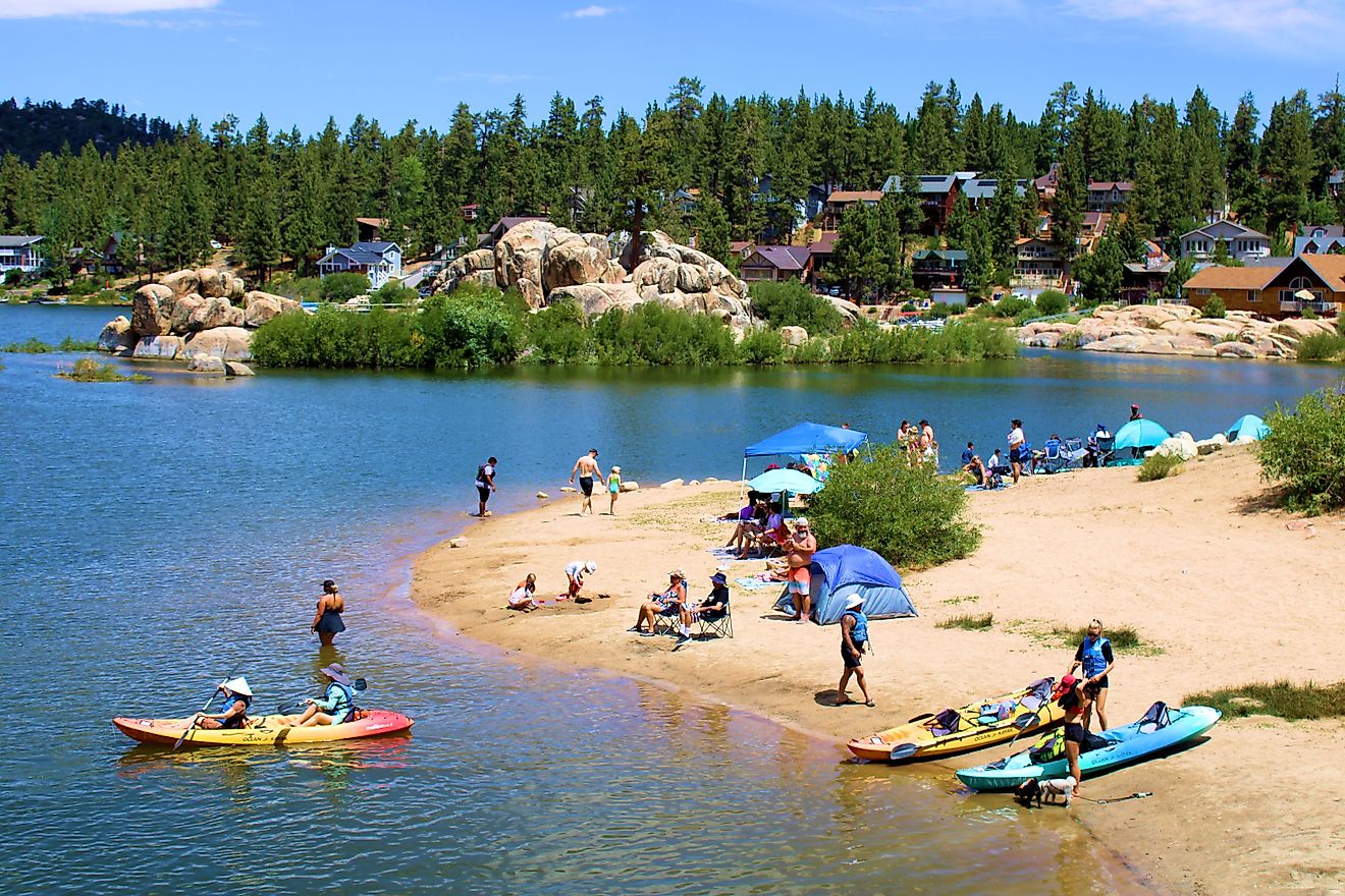
Lake Tahoe

Straddling the border of California and Nevada, Lake Tahoe is considered to be the largest alpine lake in the country by volume, and the nation's second deepest lake in general as well, reaching a maximum depth of 1,645 feet. It sits at an elevation of 6,223 feet and holds enough water to cover the entire state of California in roughly 14 inches! Tahoe's insane clarity is another of its defining features, with visibility often exceeding 60 feet down due to low nutrient levels and limited algae growth.
The extensive shoreline stretches about 72 miles, offering a mix of private properties, historic sites, granite outcrops, sandy beaches, and conifer forests to explore. If you want to stay for more than an afternoon, nearby communities like South Lake Tahoe and Truckee provide the bulk of modern amenities, including hotels, restaurants, and more, while Emerald Bay State Park, Ed Z'berg Sugar Pine Point State Park, and a handful of other protected green spaces skirting the lake offer campgrounds for a more rustic stay under the stars.

On the other hand, winter in this alpine region brings heavy snowfall from the surrounding Sierra Nevada slopes, drawing hundreds of thousands of skiers and snowboarders each year to the many world-class resorts overlooking Lake Tahoe.
Big Sur

The stretch of coastline known as Big Sur runs approximately 90 miles along the central California coast between Carmel and San Simeon, where the Santa Lucia Mountains rise directly from the Pacific Ocean. Towering cliffs here frequently exceed 1,000 feet above the water, with narrow terraces and isolated coves breaking the shoreline, and vast swathes of wildflower meadows further accentuating the pristine beauty of it all.
Also keep an eye open for roadside stops along the way, such as McWay Falls, which drops about 80 feet from granite cliffs directly onto a small, secluded beach, one of the few tidefalls in all of the United States. Furthermore, the iconic Bixby Creek Bridge spans 714 feet across a coastal canyon and stands 280 feet above the creek, forming one of the most photographed segments of California’s Highway 1.

Like much of coastal California, this region’s proximity to the ocean produces frequent fog, especially in summer, while annual rainfall varies sharply with elevation, supporting redwood groves in canyon interiors and scrubland along the more exposed ridges, all of which make this route a truly natural wonder and an all-time scenic drive.
Witness The Natural Beauty Of California At These Incredible Natural Attractions
California’s natural landmarks often come with scale, measurable extremes, and active geologic processes that will wow anyone who comes to see them up close. From the tallest trees on earth to the deepest basins in the U.S., each site above is a must-visit for anyone looking to get the most out of a Golden State adventure this year.