5 National & State Parks In Washington You Have To Visit
Washington State is home to some of the most attractive (and interesting) scenery in the Pacific Northwest. For those of us who enjoy exploring Mother Nature’s rich bounty, these diverse environments have been preserved in an impressive collection of national and state parks that attract millions of visitors each year. While Washington’s three national parks protect some of North America's most dramatic mountain wilderness, the state park system encompasses everything from coastal headlands to desert canyons. Together, this abundance of public lands adds up to an impressive playground for outdoor enthusiasts that rivals anywhere else in the country. Whatever your pleasure, Washington's parks deliver experiences accessible to everyone from casual day-trippers to serious backcountry adventurers.
Olympic National Park

Covering nearly a million acres on the Olympic Peninsula, Olympic National Park protects one of the most diverse ecosystems in North America. The park includes three distinct environments: glacier-capped mountains, over 70 miles of Pacific coastline, and the Hoh Rainforest. One of the world’s best examples of temperate rainforest, here you’ll thrill at the sight of massive Sitka spruce and western hemlock trees draped in moss, some of them over 300 feet tall and 1,000 years old.
The Olympic Mountains dominate the park's interior, with Mount Olympus clocking in at 7,965 feet and supporting the largest glacial system in the contiguous United States. Seven waterways radiate from these peaks, including the Elwha River, an important salmon habitat. Head to Hurricane Ridge, accessible via a 17-mile mountain road from Port Angeles, for stunning views of the mountain range and several hiking trails.

The park's coastal section travels from Ozette Lake to the Queets River and features sea stacks, tide pools, and beaches scattered with driftwood logs. Ruby Beach and Rialto Beach are among the park’s best selfie spots with their dramatic rock formations. For live music fans, the Olympic Music Festival each summer at Fort Worden State Park is a must-attend.
When To Visit: June through September is best for warm weather, though coastal areas remain accessible year-round.
Mount Rainier National Park

At an impressive 14,410 feet, Mount Rainier is the Lower 48’s most prominent mountain top. Rising from sea level and boasting several unique weather systems, the mountain supports 26 major glaciers, one of which, the Emmons Glacier, extends 4.5 miles and is the largest glacier by area in the continental United States. Rainier’s volcanic peak last erupted around 1,000 years ago but remains classified as an active volcano, with geothermal activity creating ice caves beneath the summit crater.
Paradise, on the mountain's south slope, is one of the snowiest places on the planet and holds the record of 1,122 inches in the winter of 1971-72. The lovely Paradise Inn, built in 1916 using massive Alaska yellow cedar logs, is a National Historic Landmark and a base from which to explore the Skyline Trail, which winds through subalpine meadows that burst into color with avalanche lilies, lupines, and other wildflowers each summer.

One of the longest hiking routes, the Wonderland Trail circles the entire mountain, a distance of over 93 miles. Along the way, it passes through lush valleys, ancient forests, and alpine zones while crossing numerous glacier-fed rivers. Sunrise, at 6,400 feet the highest point accessible by vehicle, boasts views of five impressive volcanic peaks on clear days, including Mount St. Helens, as well as Mount Hood in Oregon.
When To Visit: July through September is best for wildflowers and hiking, while winter brings excellent snowshoeing and cross-country skiing opportunities.
North Cascades National Park

North Cascades National Park is home to some of the most rugged mountain terrain in North America, earning it the nickname of the "American Alps." Over 300 glaciers are located within its boundaries, equaling a whopping one-third of all glaciers in the Lower 48 states, each feeding the park’s countless waterfalls and turquoise lakes. The jagged peaks, including 9,131-foot Mount Shuksan and the slightly smaller Mount Triumph, create a landscape so remote that grizzly bears still roam the high country in what is one of the last refuges for the species in the continental United States.
The North Cascades Highway is the main route through the park and has awesome viewpoints at Diablo Lake Overlook and Washington Pass. Harder to access (you can only get there by boat, trail, or floatplane), the Ross Lake National Recreation Area brushes up against the Canadian border and is where you’ll find the unique Ross Lake Resort, built in the 1950s and consisting of cozy cabins built on log floats.

The park's trail system includes everything from the wheelchair-accessible Sterling Munro Trail to the challenging Cascade Pass Trail, a centuries-old Native American trade route across the mountains. The Stehekin Valley, also only accessible by boat, floatplane, or foot, offers unique experiences like the Stehekin Pastry Company, operating from a cabin two miles from the boat landing, and Rainbow Falls, plunging over 300 feet just off the valley road.
When To Visit: The months of July through September are optimal as the North Cascades Highway is fully open and snow-free at higher elevations.
Deception Pass State Park

Washington's most-visited state park, with over two million annual visitors, Deception Pass State Park covers the area of Whidbey and Fidalgo islands and is named for the treacherous waterways between them. The 180-foot-high Deception Pass Bridge was completed in 1935 and spans 1,487 feet between the islands. It’s now designated a National Historic Monument for its unique Art Deco design.
In addition to its more than 14 miles of saltwater shoreline, the park boasts 6.5 miles of freshwater shoreline on Cranberry Lake, Pass Lake, and Campbell Lake. Bowman Bay, once a Samish Nation fishing spot, is now a launch point for kayakers, while Rosario Beach features tide pools harboring purple sea urchins, ochre sea stars, and giant green anemones. Old stone kitchen shelters built here in the 1930s still provide cozy picnic spaces.
The park is also no slouch when it comes to hiking, either. Its 38 miles of trails range from the easy Sand Dune Trail through coastal forest to the more challenging Goose Rock Perimeter Trail with its spectacular 360-degree views of the San Juan Islands and Olympic Mountains. Enjoy fishing? Pass Lake supports a catch-and-release fly-fishing-only fishery for cutthroat and rainbow trout, while Cranberry Lake’s boggy environment is home to carnivorous sundew plants and Labrador tea.
When To Visit: April through October is best for fans of warmer weather, though winter storms do create dramatic wave-watching opportunities.
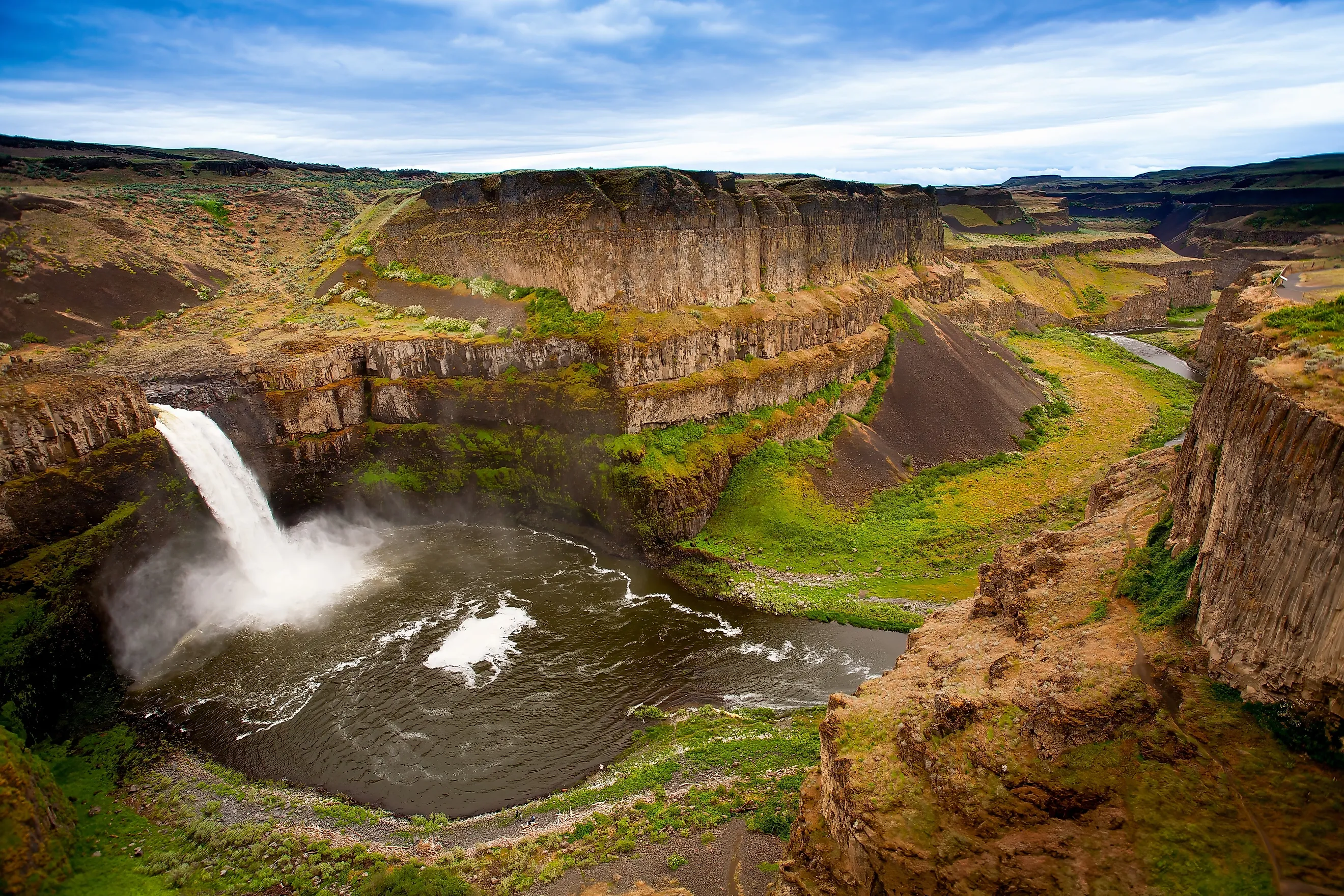
Palouse Falls State Park

Protecting Washington's official state waterfall, Palouse Falls State Park, is where the Palouse River plunges 198 feet into a basalt canyon carved by the catastrophic Missoula Floods around 13,000 years ago. The result of a failing ice dam holding back Glacial Lake Missoula, huge floodwaters carved out the distinctive scabland topography of eastern Washington. The falls once stood 20 miles downstream at the river's confluence with the Snake River but retreated to their current position as flooding eroded the basalt bedrock.
The surrounding canyon walls reveal layer upon layer of Columbia River Basalt Group lava flows, some dating back 15 million years and visible from the park's dramatic overlooks. Spring runoff in March and April can see water volumes exceed 18,000 cubic feet per second, causing a thunderous roar that can be heard a mile away. The resulting mist is equally impressive and supports moisture-loving plants in an otherwise dry landscape.
The water beneath the falls, known as the Palouse Falls Plunge Pool, reaches depths of 115 feet and has seen bones from woolly mammoths and other Pleistocene creatures that were swept over the falls during the floods. The best way to get a sense of this unique place is to follow the Fryxell Overlook Trail with its multiple viewpoints of the falls and canyon.
When To Visit: March through May is an ideal time for peak water flows.
The Final Word
Washington's national and state parks have done a remarkable job of preserving the region’s diverse ecosystems. From the Olympic Peninsula's temperate rainforests to the Columbia Plateau's flood-carved canyons, each park provides opportunities to see stunning landscapes that continue to attract visitors from across the globe. Whether you're planning a backpacking adventure or a family day trip, these five Washington parks are well worth including on your Pacific Northwest travel itinerary.