Where is Cuyahoga County, Ohio?
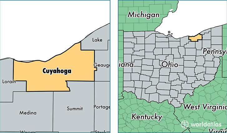
Cuyahoga County is a county equivalent area found in Ohio, USA. The county government of Cuyahoga is found in the county seat of Cleveland.
With a total 3,225.9 sq. km of land and water area, Cuyahoga County, Ohio is the 556th largest county equivalent area in the United States. Home to 1,259,828 people, Cuyahoga County has a total 617545 households earning 43804 on average per year.
Cuyahoga County, Ohio offers the following attractions to visitors: USS Cod (SS-224), Rock and Roll Hall of Fame, Great Lakes Science Center, James A. Garfield Tomb, David Berger NMEM
Cuyahoga is the home to these professional sports teams: Indians (MLB), Browns (NFL), Cleveland Cavaliers (NBA)
Cuyahoga County, Ohio - Quick Facts
| FIPS Code | 39035 |
| Area Codes | 440,216 |
| Time Zone | EST |
| Major Cities | Cleveland (population: 760,305), Lakewood (population: 51,631), Strongsville (population: 44,260), Euclid (population: 41,440), Beachwood (population: 33,657), North Olmsted (population: 32,516), Westlake (population: 32,345), North Royalton (population: 30,037), Bedford (population: 29,412), Solon (population: 24,070) |
| Land Area | 486,422 sq miles |
| Water Area | 457 sq miles |
| Household Income | $43,804 |
| Housing Units | 617,545 |
| Median Home Value | $125,700 |
| High School Grads | 88% of population |
| Holders of Bachelors Degrees | 30% of population |
| Retail Spending | $11,193 per capita |
| Food & Accomodation Sales | $2,499,199 per capita |
| Universities and Colleges | Academy of Court Reporting-Cleveland, Bryant and Stratton College-Parma, Fairview Beauty Academy, Inner State Beauty School, ATS Institute of Technology, Beachland Technology Group, Great Lakes Health Institute LC, Notre Dame College, Baldwin-Wallace College |