6 Must-See Historic Forts In Rhode Island
Stand inside Fort Adams in Newport and you can walk through tunnels that once held cannons aimed at the entrance to Narragansett Bay. A short ferry ride away, Fort Wetherill's concrete bunkers look out over the same water from the opposite shore. Inland in Portsmouth, the earthen ramparts of Butts Hill Fort still trace the layout where Continental troops fought the British in August 1778. Six forts across Rhode Island span Revolutionary War earthworks to World War II coastal artillery, and most of them now sit inside public parks that are free to visit.
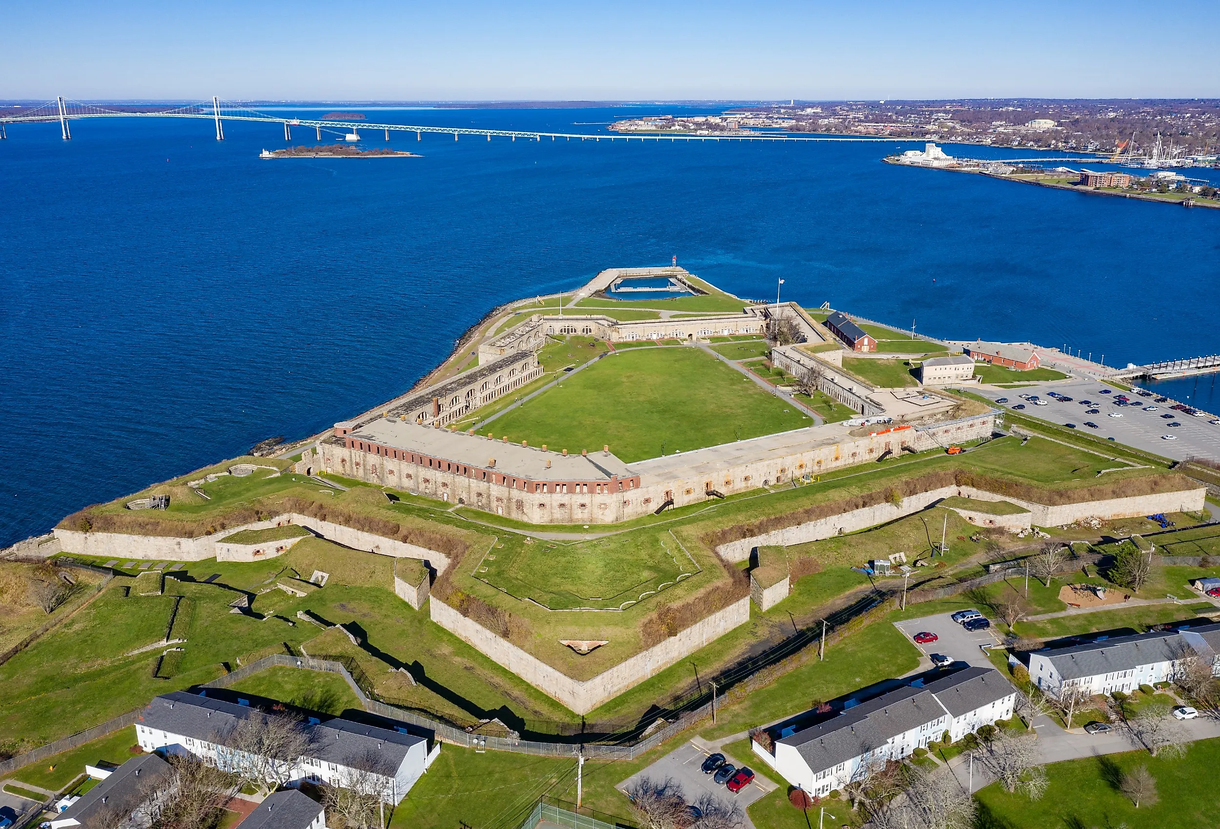
Fort Adams, Newport

Just outside Newport, Fort Adams was built between 1824 and 1857 and remained an active US Army post until 1950. Named for President John Adams, the current fort replaced an earlier 1799 fortification on the same site. Fort Adams was garrisoned during the Mexican-American War, the Civil War, the Spanish-American War, and both World Wars. It was the second fort built under the Third System of US coastal fortifications, after Fort Monroe in Virginia, and is rivaled in scale only by Monroe and Fort Jefferson in the Dry Tortugas. Three tiers of cannon positions covered the entrance to Narragansett Bay.

Fort Adams now sits inside an 80-acre state park. Visitors can tour the fort, attend the Music at the Fort summer concert series, fish from the seawall, and watch sailing regattas pass through the bay below. The park also hosts the Newport Beer Festival in May and the Fourth of July fireworks display, and is best known as the home of the Newport Folk Festival and Newport Jazz Festival.
Fort Wetherill, Jamestown

Across the East Passage of Narragansett Bay from Fort Adams, Fort Wetherill on Conanicut Island in Jamestown also sits inside a public state park. The current concrete coastal artillery fort was built between 1899 and 1906 as part of the Endicott-period Coast Defenses of Narragansett Bay and remained in service through World War II. The same site held an earlier Revolutionary War fortification known as Fort Dumpling. Fort Wetherill State Park covers 61.5 acres of rocky cliffs above the bay, with paths leading down to small coves popular with scuba divers, plus boat ramps, fishing access, and dramatic views back across to Newport.
Butts Hill Fort, Portsmouth

In Portsmouth, Butts Hill Fort is the largest surviving Revolutionary War earthwork in southern New England. American militia first built a small battery here in 1776. After British and Hessian troops occupied Aquidneck Island that December, they greatly expanded the fortification. By the time the British evacuated in October 1779, Butts Hill served as the Continental Army's main fortified position during the August 1778 Battle of Rhode Island. Earthen ramparts, gun emplacements, and interpretive trail markers still trace the layout. The state took ownership of the site in 1968 after decades of overgrowth, and the Butts Hill Fort Restoration Committee continues clearing brush and stabilizing the earthworks. The grounds are open for hiking, picnicking, and viewing the battlefield interpretive panels.
Fort Barton, Tiverton

One town over from Portsmouth, Fort Barton in Tiverton was another Revolutionary War earthwork that figured in the Battle of Rhode Island, serving as a staging point for Continental and militia troops crossing to Aquidneck Island. The fort was named for Lieutenant Colonel William Barton, who in July 1777 led a daring midnight raid that captured British General Richard Prescott from the Overing House in Portsmouth. The fort itself overlooked the Sakonnet River and the ferry crossings to the island.
Fort Barton Woods, the 200-plus-acre town park around the old fort, has roughly three miles of marked trails through hardwood forest along Sin and Flesh Brook, with a stone observation tower at the original fort site offering long views across the Sakonnet River to Aquidneck Island. Dogs are welcome on leash.
Fort Ninigret, Charlestown

West of downtown Charlestown is Fort Ninigret, a small earthwork that historians have associated with the Niantic people and possibly with Dutch traders in the 1630s, though the actual origin remains uncertain. Spanish swords and Dutch cannons have been recovered from the site over the years. Rhode Island has maintained the property as a public park since 1883. The site features a memorial boulder dedicated to the Niantic, plus picnic facilities. East Beach (the Charlestown end of a long barrier beach with about three miles of frontage on Block Island Sound) is just south of the fort site and is a popular summer swimming spot.
Fort Greble, Dutch Island

Fort Greble sits on Dutch Island in the West Passage of Narragansett Bay. Construction began during the Civil War, and the post was reconstructed and expanded around 1898 with concrete coastal artillery batteries during the Endicott period. At its peak during World War I, the fort housed nearly 500 troops, with officers' quarters, a hospital, two docks, tennis courts, and a post office that ran from 1908 to 1947. The Army deactivated the post after World War II.
The island is now uninhabited and managed as a Rhode Island Department of Environmental Management wildlife area. It's a good destination for kayakers and small boats, with picnic spots and ruins to explore. The Dutch Island Lighthouse on the southern tip of the island is a 42-foot brick tower built in 1857, replacing an earlier stone tower lit on January 1, 1827. The light was relit in 2007 after a long restoration and is best viewed from the water (the interior is closed to the public).
Six Forts, Six Stories
These forts cover most of Rhode Island's military history (Revolutionary earthworks at Butts Hill and Fort Barton, the trade-era Fort Ninigret in Charlestown, and Civil War to World War II coastal artillery at Fort Adams, Fort Wetherill, and Fort Greble). All sit inside public parks today, most are free to visit, and several anchor towns where you can pair fort tours with beaches, ferries, and waterfront restaurants.