The Easternmost Point in North America Is Actually West of Alaska
- Amatignak Island in Alaska with gps coordinates 51°16′7″N 179°8′55″W is the westernmost point in all US territories by longitude
- Semisopochnoi Island in Alaska with gps coordinates 51°57′42″N 179°46′23″E – easternmost point in all US territory by longitude
In the contiguous United States, the farthest east anyone can stand is Sail Rock, a rugged tidal ledge off the coast of Lubec, Maine (coordinates: 44°48′45.2″N 66°56′49.3″W). Lubec itself is a fishing village at the northeastern tip of Maine, perched on a peninsula where the Bay of Fundy meets the Atlantic Ocean. But Sail Rock is not the easternmost point of the entire United States. That title belongs to Point Udall, a windswept headland on the eastern shore of St. Croix in the U.S. Virgin Islands (coordinates: 17°45′19″N 64°33′54″W). Named after Stewart Udall, Secretary of the Interior under Presidents Kennedy and Johnson, Point Udall is home to the Millennium Monument, a sundial erected in 2000 to mark the spot where the first rays of sunlight touch U.S. soil each morning. A twin landmark with the same name sits at the westernmost point of the United States in Guam, honoring Stewart's brother, Morris Udall, a longtime Arizona congressman.
And yet, neither Sail Rock nor Point Udall holds the true easternmost title by longitude. That distinction belongs to an uninhabited volcanic island in Alaska, a state that also claims the westernmost point in the country. The explanation lies in the way hemispheres are drawn on a map.
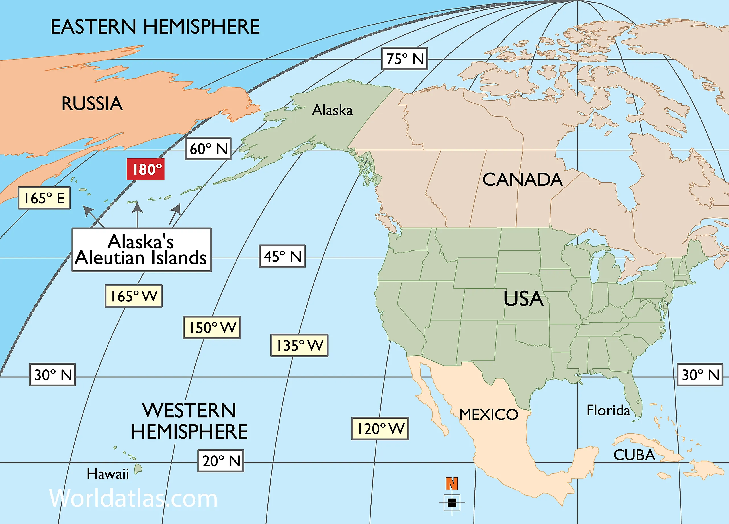
Division Between Western and Eastern Hemispheres
The prime meridian, running through Greenwich, England, and the 180th meridian, slicing through the remote Pacific Ocean, together form a great circle that divides Earth into the Western Hemisphere and the Eastern Hemisphere. The United States falls almost completely in the Western Hemisphere. The key word is "almost." A handful of U.S. territories sit well into the Eastern Hemisphere: Guam, Saipan, Wake Island, and several other Pacific islands all lie on the far side of the 180th meridian. But it is not just territories that cross the line. Alaska's own Aleutian Islands, that long volcanic chain arcing southwest from the mainland, stretch far enough across the North Pacific to cross the 180th meridian entirely, placing a small cluster of islands in the Eastern Hemisphere. This geographic quirk means the United States does not simply straddle two time zones or two coasts. It straddles two hemispheres, and that changes everything about how we define its most extreme points.
Most Eastern Point in the United States
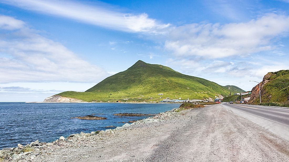
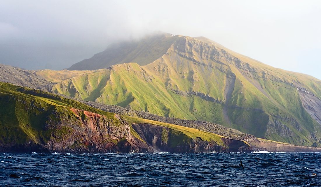
Alaska's Aleutian Islands arc across nearly 1,900 kilometers (1,200 miles) of open ocean, reaching right up to the edge of the Western Hemisphere. Amatignak Island (51°16′7″N 179°8′55″W), a treeless, wind-battered speck in the Delarof Islands group, sits just west of the 180th meridian, making it the westernmost point in the United States by longitude. But the chain does not stop there. A few islands push past the line and into the Eastern Hemisphere, and among them is Semisopochnoi Island (51°57′42″N 179°46′23″E), a volcanically active island roughly 14 minutes of longitude east of the 180th meridian. Its name comes from the Aleut word for "the seventh island," counting westward from the Andreanof group. Semisopochnoi is uninhabited by people but supports colonies of seabirds, sea otters, and Steller sea lions across its roughly 221 square kilometers (85 square miles) of volcanic terrain. Its position just past the hemispheric dividing line makes it, by strict longitudinal measurement, the easternmost point in the entire United States.
The result is a geographic paradox that catches nearly everyone off guard. Alaska is simultaneously the northernmost, westernmost, and easternmost state in the country. Only the southernmost title escapes it, belonging to Hawaii. So the next time someone asks where the East Coast ends, the technically correct answer is not Maine, not the Virgin Islands, but a remote, volcanic island in the Aleutians where the Western Hemisphere gives way to the Eastern, and the United States quietly begins again on the other side of the line.