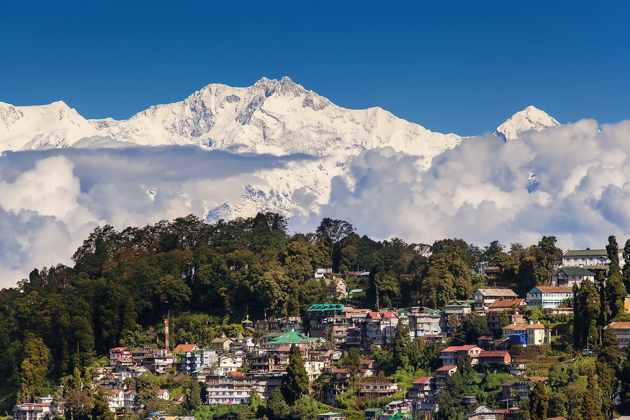
Darjeeling, India
Nestled in the slopes of the Lesser Himalayas at an elevation of 2,042.16m, Darjeeling is a small city and a municipality in the Darjeeling district of the Indian State of West Bengal. The name “Darjeeling” has been derived from the Tibetan words, ‘Dorje’ which refers to the powerful thunderbolt weapon of Indra –the Hindu God of Lightning and thunder; and ‘Ling,’ which means 'land.’ Therefore, Darjeeling means the “land of the thunderbolts.” Also referred to as the “Queen of Hills,” this scenic hill station is noted for offering spectacular views of Mount Kanchenjunga – the world’s third-highest mountain, tea plantations, and various well-known attractions, that make Darjeeling one of the most favored tourist destinations in India attracting thousands of domestic as well as international tourists.
Geography Of Darjeeling

Darjeeling is a small city located in the Darjeeling Himalayan hill region of the Eastern Himalaya range, on the north-western part of the Indian State of West Bengal. Darjeeling serves as the administrative headquarters of the Darjeeling district and the principal town of the Darjeeling Sadar subdivision. Geographically, the Darjeeling district has the shape of an irregular triangle, with its northern portion forming a part of the Great Himalayas, while its southern portion forming a part of the Tarai region along the base of the hills. The location of the Darjeeling district is strategically significant as it shares its boundaries with Nepal, Bhutan, and Bangladesh, besides other Indian territories (Sikkim, Bihar, and parts of West Bengal). Some of the notable rivers that flow in the district include Teesta, Mahananda, Jaldhaka, Mechi, Rangeet, and Rammam.

The city of Darjeeling covers an area of only 10.60 sq. km and is situated approximately 621.6km north of the city of Kolkata – the capital of the State of West Bengal; 30.1km from Kurseong, 51.4km from Kalimpong, and 77km from Siliguri. The city is well connected by roadways, railways, and aviation facilities with the other major cities of India. Located about 90km away from Darjeeling, the Bagdogra Airport is the nearest airport, while the New Jalpaiguri Junction is the closest railway station. Darjeeling is also linked with the New Jalpaiguri Junction railway station by the 88km long Darjeeling Himalayan Railway – a UNESCO World Heritage Site and one of India’s mountain railways. The city of Darjeeling is prone to frequent earthquakes as it is located close to the convergent boundary of the Indian and Eurasian tectonic plates and falls under Seismic Zone-IV.
Climate
According to the Köppen climate classification, Darjeeling experiences a subtropical highland climate. As per the records of the Indian Meteorological Department, the annual mean maximum temperature of Darjeeling is 17.2°C, and the annual mean minimum temperature is 8.5°C. Darjeeling receives moderate to heavy rainfall from June to September. With an average of 105 rainy days in a year, the city gets an average annual precipitation of 2,380mm. The heavy rainfall often causes devastating landslides leading to the loss of lives and property damage. The city can go on for many years without receiving snow, as snowfall is quite a rare feature in Darjeeling.
Demography And Economy Of Darjeeling

As per the 2011 census, the Darjeeling urban agglomeration is home to 132,016 people, of which 66,177 are females, and 65,839 are males. The city has a population density of 413 persons per sq. km. A significant portion of the city’s population are Nepali Indians (Indian Gorkhas), followed by the Lepchas, Bhutias, Tibetans, Bengalis, Anglo-Indians, Marwaris, etc. Even though Nepali is the most widely spoken language in Darjeeling, other languages like Bengali, Hindi, English, and Tibetan are also spoken.
The economy of Darjeeling is mainly driven by the tourism and tea industry. Darjeeling produces approximately 9,000,000 kg of tea every year, accounting for 7% of India’s tea output. Darjeeling Tea which is grown in the tea plantations of Darjeeling and Kalimpong districts of West Bengal is internationally reputed and recognized as a geographical indicator. The unique agro-climatic conditions of Darjeeling provide the distinctive natural flavor and aroma of Darjeeling Tea, making it one of the most famous varieties of tea in the world. Besides tea, other major crops grown in Darjeeling include cardamon, ginger, maize, millets, paddy, and potato.
Tourist Attractions In Darjeeling
Tiger Hill

Located at an altitude of 2590m and about 11km from the town of Darjeeling, Tiger Hill provides panoramic views of Mount Kanchenjunga – the world’s third-highest mountain and Mount Everest – the world’s highest mountain. Due to the curvature of the Earth, Mount Kanchenjunga appears higher than Mount Everest, as it is much closer than that of Mount Everest. The distance from Tiger Hill to Everest is about 172km.
Darjeeling Mall

The Darjeeling Mall or Chowrasta is a historic public square located at the heart of the Darjeeling town, about 1km from Darjeeling Himalayan Railway Station. The Mall area serves as a major shopping hub and a center for commercial activities in Darjeeling. Several benches are located along the Mall road for visitors to sit and enjoy the spectacular mountain views while sipping a cup of Darjeeling tea. Also located close to the Mall is Observatory Hill and the temple of Mahakal.
Ghoom Monastery

Located next to Sterling Darjeeling at the end of the Old Monastery Road is the historic Ghoom Monastery (Yiga Choeling Monastery) which was built by a Mongolian monk named Sherpa Gyaltsho in 1850. The Ghoom Monastery houses a 15ft high Maitreya Buddha statue and an extensive collection of invaluable manuscripts. The monastery also serves as a storehouse of the Tibetan translations of well-known literary works, including Meghadoot by Kalidasa, Nyayakrit by Dharmakriti, and Nagamandala by Sriharsa.
Batasia Loop

Located about 5km from Darjeeling town just below the Ghoom station, Batasia Loop is a spiral railway that was created to gradually lower the gradient of ascent of the Darjeeling Himalayan Railway. Placed at the center of the Batasia Loop is a War Memorial dedicated to the brave Gorkha soldiers who sacrificed their lives after Indian Independence.
Himalayan Mountaineering Institute

One of the world’s premier mountaineering institutes, the Himalayan Mountaineering Institute, was established in Darjeeling on November 4, 1954, by Pandit Jawaharlal Nehru, to commemorate the first successful ascent of Mount Everest by Sir Edmund Percival Hillary and Tenzing Norgay. The institute was established to promote mountaineering as an organized sport in India.
Padmaja Naidu Himalayan Zoological Park

Also referred to as the Darjeeling Zoo, the Padmaja Naidu Himalayan Zoological Park is a small zoo situated in the Birch Hill neighborhood of Darjeeling. Established on August 14, 1958, the Darjeeling Zoo located at an elevation of 2,134m is India’s largest high-altitude zoo. The Darjeeling Zoo specializes in breeding animals adapted to the alpine conditions and runs successful captive breeding programs for several endangered animals like the red panda, snow leopard, Himalayan wolf, etc. The Darjeeling Zoo attracts more than 300,000 visitors annually.
Peace Pagoda

Located on the slopes of Jalapahar Hills, the Darjeeling Peace Pagoda was constructed in 1972 under the guidance of a Japanese Buddhist monk named Nichidatsu Fuji. The pagoda houses four avatars of Buddha. From the top of the Pagoda, the visitors can get panoramic views of the surrounding mountain landscape. The Peace Pagoda stands as a symbol of peace and unity in Darjeeling.
Brief History Of Darjeeling

It is believed that till the beginning of the 19th century, the hilly area around Darjeeling was under the control of the Kingdom of Sikkim. During this time, the Chogyal of Sikkim was engaged in an unsuccessful warfare against the Gorkhas of Nepal. The Gorkhas had made several attempts to capture the entire Darjeeling region from 1780 onwards. The British Army was also engaged in preventing the Gorkhas from capturing the entire northern frontier region. In 1814, the Anglo-Nepalese War broke out between the Gorkhas and the British, which eventually led to the defeat of the Gorkhas and the signing of the Sagauli Treaty in 1816. As per the terms of the Sagauli Treaty, all the territories that Nepal annexed from the Chogyal of Sikkim were handed over to the British East India Company. The British East India Company reinstated the Chogyal of Sikkim in 1817 as per the Treaty of Titalia. A British East India Company delegation selected the area in 1828 as a suitable site for establishing a sanatorium for the British soldiers.
In 1835, a part of the Darjeeling hill area was ceded to the British by the Chogyal of Sikkim. The temperate climate of Darjeeling also favored its development as a hill station for the Britishers. A military depot was set up in 1848, and in 1850 the town became a municipality. In 1856, the commercial cultivation of tea began in Darjeeling. It has been recorded that by the beginning of the 20th century, there were more than 100 tea gardens with about 64,000 employers. In 1864, Darjeeling became the summer capital of the Bengal Presidency. In 1881, the opening of the Darjeeling Himalayan Railway further accelerated the development of the entire region. After Indian Independence, the Gorkhaland movement began, which demanded the autonomy of Darjeeling and the creation of a separate Indian State in the Gorkhaland region for the Nepali Gorkhas. In July 2011, a pact was signed between the Government of India, the Government of West Bengal, and the Gorkha Janmukti Morcha to form an autonomous, elected hill council named the Gorkhaland Territorial Administration (GTA).