9 Of The Friendliest Towns In Tennessee
Friendliness in Tennessee shows up most clearly in the smaller towns where the population stays low enough that locals still recognize each other on the street. Several of the nine towns ahead played significant roles in the Civil War. One produced a sitting U.S. president and kept the tailor shop where he worked. Another was settled by German immigrant families who kept the cultural ties active for decades. Each of the rest runs on its own particular mix of history, river access, and old-fashioned Main Street commerce.
Greeneville

Greeneville was founded in 1783 and ranks as Tennessee's second-oldest town, behind only Jonesborough four years its senior. About 15,500 people live there today. Located near the Appalachian Mountains in Greene County, Greeneville hosts the Greene County Fair every August (running since 1869) along with smaller community festivals and local sports leagues throughout the year. The historic district holds an unusual concentration of 18th and 19th-century buildings preserved in working condition. The Andrew Johnson National Historic Site preserves the tailor shop where the 17th president worked, his two homes, and his burial place on the hill above town. The nearby Maden Hall, built around 1825 and now privately operated, is one of the most architecturally significant Federal-style farmhouses in East Tennessee.
Germantown

Germantown was incorporated in 1841 as a settlement of German immigrant families who maintained their cultural ties through the late 19th century. The town now sits at the eastern edge of the Memphis metropolitan area with about 41,300 residents and serves as one of the wealthiest suburbs in the state. Germantown reports one of Tennessee's lowest crime rates and runs annual events including the Germantown Charity Horse Show (since 1948, one of the oldest hunter-jumper shows in the country) and the Germantown Festival, a two-day September event that fills downtown with local artists and craftspeople. Fort Germantown, a Civil War earthworks fortification listed on the National Register of Historic Places, sits at the corner of Honey Tree and Poplar Pike and runs interpretive programs explaining the Union occupation of the area.
Kingston Springs

Kingston Springs sits along the Harpeth River about 25 miles west of Nashville. About 3,150 people live there, with the population growing slowly as Nashville exurban development pushes outward. The town is named for the mineral springs that drew 19th-century visitors before the springs themselves dried up. Today the Harpeth River does most of the recreational work. Outdoor outfitters like Foggy Bottom Canoe rent kayaks and canoes for trips through the Narrows of the Harpeth, a section where the river loops around a high ridge in a narrow oxbow.
The downtown area is small but has steadily added local businesses over the past decade, including a handful of locally owned diners and the Kingston Springs Coffee Company. The Montgomery Bell Academy Camp and the nearby Harpeth River State Park provide additional outdoor access. The town's compact size means most weekend errands and dining happen within a few blocks.
Tellico Plains

Tellico Plains was incorporated in 1911 along the Tellico River at the western edge of the Cherokee National Forest and the Unicoi Mountains, with about 870 residents. The town serves as the western trailhead of the Cherohala Skyway, a 43-mile National Scenic Byway completed in 1996 that climbs over 5,400 feet at Haw Knob before descending to Robbinsville, North Carolina. Bald River Falls, a 90-foot cascade about 15 miles east of town along the Cherohala, is one of the most-photographed waterfalls in the state. Tellico Trout Hatchery operates a working freshwater hatchery just south of town with a visitor center and stocked ponds. The town itself runs a small grid of local restaurants and outfitters serving Cherokee National Forest visitors.
Dover

Dover is the seat of Stewart County, about 67 miles northwest of Nashville on the Cumberland River. About 1,500 people live in town. Fort Donelson National Battlefield, immediately west of downtown, preserves the site of Ulysses S. Grant's February 1862 victory that earned him the nickname "Unconditional Surrender Grant" and gave the Union control of the Cumberland and Tennessee rivers. The battlefield includes the river batteries, the Confederate defensive lines, the Dover Hotel where the surrender was negotiated, and a National Cemetery.
Cross Creeks National Wildlife Refuge, established in 1962 along Lake Barkley, covers 8,862 acres and serves as a major wintering ground for sandhill cranes and waterfowl, with peak counts exceeding 50,000 ducks in winter. The Land Between the Lakes National Recreation Area, the largest inland peninsula recreation area in the country at 170,000 acres, sits immediately west of Dover and offers extensive trail, lake, and camping access.
Tiptonville

Tiptonville sits in the northwestern corner of Tennessee along Reelfoot Lake near the Mississippi River, with a population of about 2,440. The town was chartered in 1857. Reelfoot Lake, the town's defining feature, was created by the New Madrid earthquakes of December 1811 and January-February 1812, when ground subsidence and the temporary reverse flow of the Mississippi River filled the basin. The lake is now a 15,000-acre state park and wildlife refuge.
Reelfoot Lake State Park offers boating, hiking, and wildlife watching, with one of the largest bald eagle wintering populations in the eastern United States. Lake Isom National Wildlife Refuge, just south of town, is part of the same Mississippi Flyway corridor and adds another 1,850 acres of bottomland habitat. The town itself runs a small downtown serving the lake's fishing and birding tourists, including Boyette's Restaurant, in business since 1921 and known for its frog legs and catfish dinners.
Linden

Linden was incorporated in 1849 as the seat of Perry County, with a current population of about 840. The town sits along the Tennessee Buffalo River, which runs about 125 miles as the longest unimpounded river left in the state. The Perry County Courthouse on the square, built in 1928 after the previous courthouse burned, is a Classical Revival structure that anchors the small downtown.
Mousetail Landing State Park, on the eastern bank of Kentucky Lake about 12 miles north of Linden, runs 1,247 acres of forested camping, swimming, fishing, and boating access, with a name that comes from the leather tannery rats that fled to the riverbank during a 19th-century fire. The Buffalo River itself supports the longest float-trip route in middle Tennessee, and local outfitters in town run canoe shuttles upstream during the May-October season.
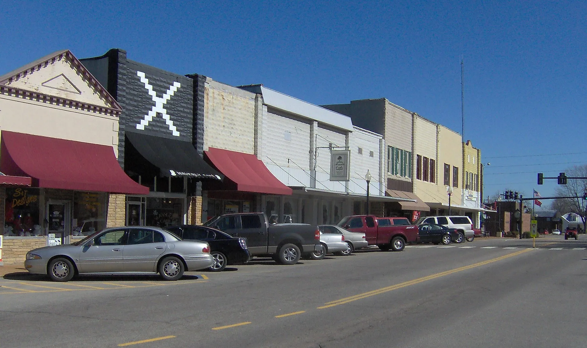
Waverly

Waverly was founded in 1838 and runs about 4,100 residents as the seat of Humphreys County, about 65 miles west of Nashville. The town sits along the Tennessee River drainage and was the site of the Battle of Johnsonville on November 4-5, 1864, when Confederate cavalry under Nathan Bedford Forrest destroyed a major Union supply depot on the river. Johnsonville State Historic Park preserves the earthworks, with a museum covering the engagement and the broader river-supply war.
The town was also the site of a fatal 2021 flash flood that killed 20 residents when 17 inches of rain fell in a few hours. The flood recovery has shaped much of the town's recent civic effort. Local landmarks include the Loretta Lynn Ranch in nearby Hurricane Mills (about 8 miles north), which runs museum tours of the singer's home and the working ranch she purchased in 1966.
Ashland City

Ashland City was incorporated in 1859 as the seat of Cheatham County, about 20 miles northwest of downtown Nashville. About 5,200 people live in town. The town sits near the confluence of the Harpeth River and the Cumberland River, which gives Ashland City unusually good water access for a Middle Tennessee community of its size.
The Cumberland River Bicentennial Trail, a 4-mile paved rail-trail, follows the riverbank south from town and offers some of the best riverside cycling in Middle Tennessee. The Narrows of the Harpeth State Historic Park, about 12 miles south, preserves the Pattison Forge, a 19th-century industrial complex that used a 290-foot artificial tunnel through a rock ridge to drive water-powered iron and brass works.
What These Nine Towns Share
The nine towns above run on different industries, sit in different parts of the state, and trace their histories to different decades, but they share one common feature. Each town has stayed small enough that the friendliness people remember is not a marketing tagline but a working consequence of population scale. Greeneville and Germantown are the larger ones, both still walkable. Tellico Plains and Linden are the smallest, both still functional. Each town earns its spot on this list through what it has not done, namely outgrow the people who live in it.