13 Best Places To Live In California
Forget Los Angeles and San Francisco. The Golden State has a quieter side that is more affordable than the headlines suggest. Borrego Springs sits inside the largest state park in California with the trailhead closer than the grocery store. Lone Pine looks straight up at Mount Whitney, the highest peak in the lower 48. Julian still pours gold-rush coffee on a Main Street whose historic core holds California Historical Landmark status. The thirteen towns below trade traffic for trail access and city rents for something a working family or a quieter retirement can actually live with.
Borrego Springs

Borrego Springs is wholly surrounded by Anza-Borrego Desert State Park, the largest state park in California at 600,000 acres, and the only state park in the country that has been certified an International Dark Sky Park. The town has a single stoplight and a year-round population around 3,400, with a winter population that roughly doubles. Hellhole Canyon and Borrego Palm Canyon trails leave directly from the edge of town and run into the badlands. Galleta Meadows on the north side of town holds 130 large rusted-steel sculptures by Ricardo Breceda, an open-air installation funded by the late developer Dennis Avery. The Borrego Medical Clinic on Christmas Circle handles routine care; for hospital care, residents drive 80 miles east to El Centro Regional or 100 miles southwest to Palomar Medical Center in Escondido.
Oakdale

Oakdale calls itself the Cowboy Capital of the World, a slogan it earned in the 1950s and 1960s when local cowboys won an unusual concentration of world rodeo titles. The Oakdale Cowboy Museum on East F Street tells that story from inside a restored 1907 building. The Oakdale Saddle Club hosts the annual Oakdale Rodeo every April, running since 1951 and one of the longest-running rodeos in the state. The Stanislaus River runs along the eastern edge of town for fishing, kayaking, and rafting, and Knights Ferry Recreation Area, 12 miles east, holds California's longest covered bridge (built in 1864). Oak Valley Hospital is a small acute-care hospital on West H Street; Modesto's larger hospitals are about 15 miles southwest.
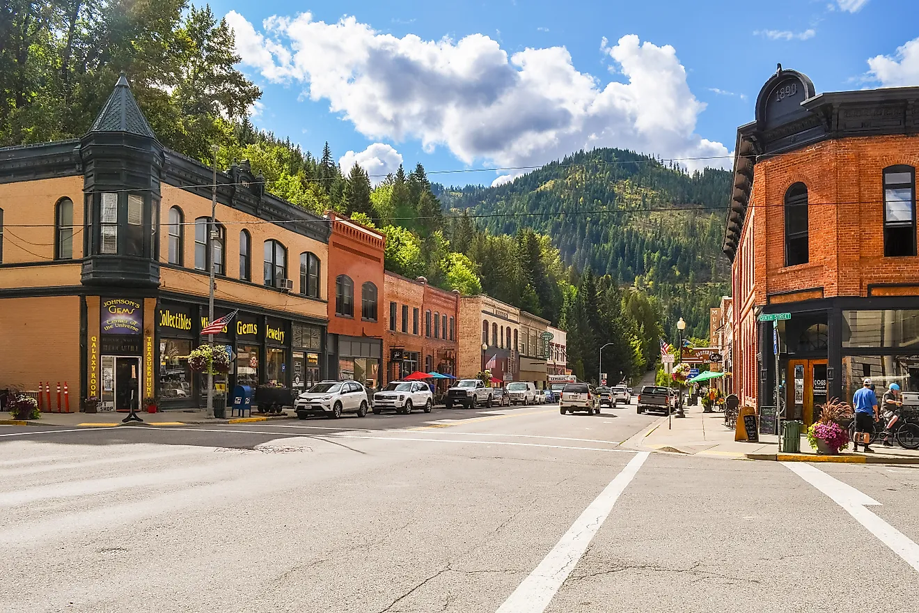
Murphys

Murphys is a Sierra Nevada foothill town in Calaveras County, founded in 1848 as a Gold Rush mining camp and named for John and Daniel Murphy. The Main Street historic district preserves limestone and brick buildings from the 1850s, including the Murphys Historic Hotel where Mark Twain, Ulysses Grant, and Susan B. Anthony all stayed. The town hosts more than 25 wineries with tasting rooms downtown, making it one of the densest concentrations of wine tasting on a single Main Street in California. Mark Twain Medical Center is 15 miles west in San Andreas. Mercer Caverns, a working show cave just north of town, runs year-round tours of the limestone formations discovered in 1885.
Rio Vista

Rio Vista sits on the Sacramento River in the Sacramento-San Joaquin Delta, in Solano County's eastern corner. The town runs about 10,000 residents on the western bank of the river, with farmland on three sides and the Delta on the fourth. Brannan Island State Recreation Area, just south of town, holds 336 acres on the river with campsites, boat launches, and the swimming pond at Seven Mile Slough. The Rio Vista Bass Festival, held every October since 1933, is one of the oldest fishing festivals in the state and shuts down Main Street for a weekend. Trilogy at Rio Vista, a Shea Homes 55-and-up community on the west side, anchors the local retiree population. Sacramento sits 47 miles north on Highway 12.
Laguna Woods

Laguna Woods is an Orange County city built around Laguna Woods Village, a 55-and-older community that was originally Leisure World when it opened in 1964. The Village holds about 18,000 residents (the city as a whole is around 16,500), making it one of the largest active-adult communities on the West Coast. The Pacific is about nine miles west at Laguna Beach, and Aliso and Wood Canyons Wilderness Park sits directly south for hiking. The Village runs five clubhouses, two golf courses, an equestrian center, and more than 200 resident clubs, which means the social calendar is permanent. Saddleback Memorial Medical Center is two miles south in Laguna Hills.
Quincy

Quincy is the Plumas County seat in the northern Sierra Nevada, an hour east of Lake Almanor and surrounded by Plumas National Forest. The town runs about 1,700 residents, with Feather River College adding another thousand or so during the school year. The Plumas County Museum on Main Street covers Gold Rush mining history, and the Quincy Library on East Main holds the only state-designated historic library in the state. Bucks Lake Recreation Area, 17 miles southwest, runs trout fishing on a 1,825-acre reservoir that freezes solid in winter. Plumas District Hospital is a small critical-access hospital on Bucks Lake Road, and the Reno airport is two and a half hours east on Highway 70.
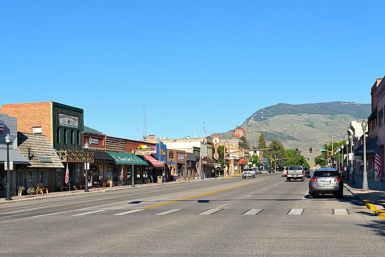
Lone Pine

Lone Pine sits in Inyo County under Mount Whitney (14,505 feet, the highest peak in the contiguous United States) and at the edge of the Alabama Hills, the rolling boulder field where more than 400 Hollywood films have been shot since 1920. The Mount Whitney Trail leaves from the Whitney Portal above town and reaches the summit in 22 miles round-trip with 6,100 feet of vertical (permits required and rationed by lottery). Lone Pine Lake, at about 2.5 miles in, is a permit-free turnaround for a daily walk. The Museum of Western Film History on Main Street covers the westerns shot in the Alabama Hills, with original costumes and gear from films starring Tom Mix, Roy Rogers, and Humphrey Bogart. Southern Inyo Hospital is the closest care; Reno is the nearest tertiary hospital, four hours north.
Chester

Chester sits on the north shore of Lake Almanor, a 28,000-acre reservoir in Plumas County that PG&E built in 1914 by damming the North Fork of the Feather River. The lake handles trout, smallmouth bass, and a strong landlocked salmon fishery, and frozen in winter for ice fishing. Lassen Volcanic National Park sits about 35 miles north, with Mount Lassen (10,457 feet, the southernmost active volcano in the Cascades) running both summer hiking and winter snowshoeing. The Lake Almanor West Golf Course runs nine holes near the western shore. Seneca Healthcare District operates the local hospital, and Chico's larger hospitals are about 75 miles southwest on Highway 32.
Mariposa

Mariposa sits in the central Sierra Nevada foothills as the southwestern entrance to Yosemite National Park, about 32 miles from Yosemite Valley on Highway 140. The 1854 Mariposa County Courthouse on Bullion Street is the oldest courthouse west of the Mississippi still in continuous use, with original wooden interior intact. The Mariposa Museum and History Center traces the gold-rush story through restored tools, mining equipment, and a working assay office. The California State Mining and Mineral Museum at the county fairgrounds holds a 13-pound crystallized gold specimen from the Colorado Quartz mine, the largest known piece of California crystallized gold. John C. Fremont Healthcare District runs the local hospital, and Fresno is about 65 miles south.
Paradise

Paradise sits on a forested ridge in Butte County and has been rebuilding since the November 2018 Camp Fire destroyed about 19,000 structures and killed 85 people, making it the deadliest wildfire in California history. The town's pre-fire population of 26,000 dropped to about 4,500 in the months after the fire and has since climbed back above 9,000. New construction follows updated wildfire-resilience codes (defensible-space requirements, ember-resistant vents, hardened siding). Bille Park covers a quiet ridge with hiking trails. Theatre on the Ridge keeps the live-arts community going in a 100-seat venue on Skyway. Adventist Health Feather River, the hospital that burned in 2018, is rebuilding services in stages, and Enloe Medical Center in Chico (15 miles west) handles major care.
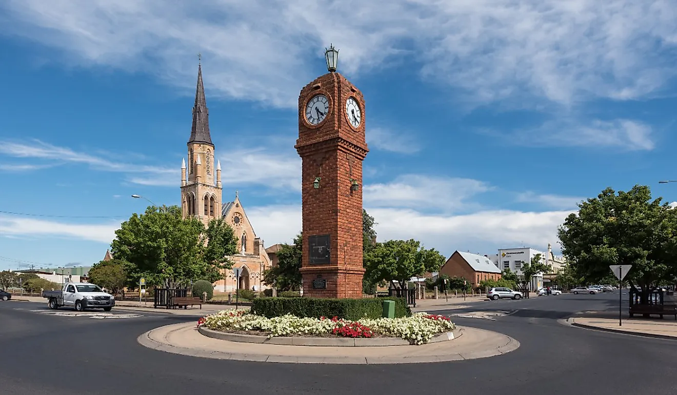
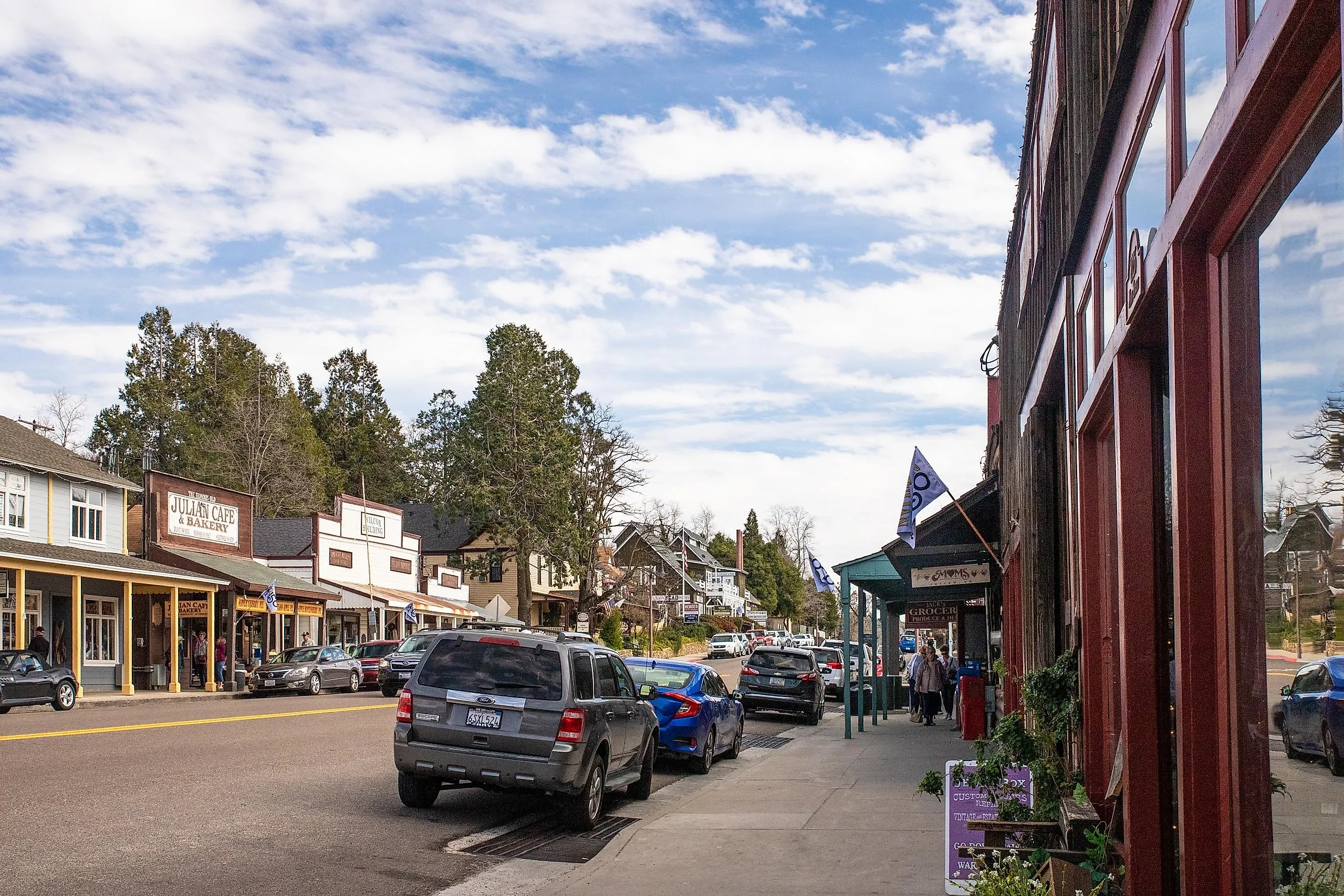
Julian

Julian is a mountain town in San Diego County's backcountry, founded in 1869 after Frederic Coleman discovered gold in a nearby creek. The historic core, designated California Historical Landmark No. 412, holds the 1872 Julian Hotel (the oldest continuously operating hotel in Southern California) and the Pioneer Cemetery on the hill above town. When the gold played out, locals planted apples in the surrounding hills, and the apple economy has run continuously since the 1880s; Julian Pie Company on Main Street ships pies nationally. William Heise County Park covers 1,000 acres of pine forest five miles south, with campsites and 22 miles of hiking trails. The town runs an annual Apple Days Festival every weekend in October. Palomar Medical Center in Escondido is 38 miles southwest.
Soledad

Soledad is a Monterey County town in the Salinas Valley, with the 1791 Mission Nuestra Señora de la Soledad on its western edge. The mission, the 13th of California's 21 Spanish missions, was largely destroyed by floods in the 19th century and partially reconstructed in the 1950s. The Salinas Valley around town runs one of the densest concentrations of premium Pinot Noir and Chardonnay vineyards in California, including Hahn Estates and Wrath Wines, both with tasting rooms a short drive from downtown. Pinnacles National Park sits 25 miles east via Highway 146 and protects the eroded remains of an extinct volcano, including the 2.6-mile Balconies Cliffs and Cave Loop and one of two California condor release sites. Soledad Medical Clinic handles primary care; Salinas Valley Memorial Hospital in Salinas is 25 miles north.
Sutter Creek

Sutter Creek is an Amador County town in the Mother Lode wine region, named for John Sutter, the Swiss émigré whose mill on the American River triggered the 1849 Gold Rush. Main Street holds a preserved row of 19th-century brick buildings, including the Sutter Creek Theater (1919, restored 2002) which runs live music in a 220-seat house. Knight Foundry on Eureka Street is the only water-powered foundry and machine shop in the country still capable of operation, dating to 1873. The Shenandoah Valley wineries (about 25 of them, including Bella Grace, Renwood, and Sobon Estate) sit a short drive northeast and run weekend tasting rooms. Sutter Amador Hospital is in nearby Jackson, four miles south.
Final Thoughts
The thirteen towns above span a real range. Borrego Springs holds the desert edge, Lone Pine pins the Sierra crest, Sutter Creek runs the wine country, and Julian sits in the apple country. None of them ask for a city budget, and none of them ask for a city compromise. If a quieter California is on the table, these are the places worth a long weekend before signing a lease.