This Car-Free Michigan Island Is Made for Strolling
Mackinac Island (pronounced: Mack-in-awe) is the name given to both the forested rock floating between Michigan's Upper and Lower Peninsulas and the vacation-friendly Victorian village occupying its southern shore. At 4.4 square miles, Mackinac Island is perfectly manageable without a car, which is good, because they were banned at the turn of the 20th century. Instead, visitors can hail a horse-drawn carriage (there are more working horses here than permanent residents), rent a single-speed bike from a shoreline operator, or, for the purposes of today's topic, stroll about the timeless (and tasty) streets, stride up to Fort Mackinac for a historic and panoramic tour, or delve deeper into Mackinac Island State Park's miles of wooded trails. However you spin it, Mackinac Island is made for strolling. Let me show you what I mean.
Lake Shore Drive

Having ferried across the Straits of Mackinac from either Mackinaw City (Lower Peninsula) or St. Ignace (Upper Peninsula), you will be met with Mackinac Island's most rambunctious side. Along with hundreds of fellow tourists (Note: there are about one million annual visitors, but the overwhelming majority come between May and October), expect a steady stream of cyclists and clomping horses. The earlier you arrive, the better. But even during peak hours, it's easy enough to wade through the crowd and find a smoother stride.

Many of the island's historic inns are congregated around the ferry docks, so you may want to head to your respective reservation first to drop off your bags. Alternatively, if you're simply here for the day, we can launch right into our wander. Lake Shore Drive is where you'll find all of Mackinac Island's world-famous fudge shops, the bulk of its gift shops, and the majority of its restaurants and watering holes. As such, this is a good opportunity to grab a meal, stock up on packable sweet treats, and make some mental notes for a post-stroll shopping spree.

Once the initial social wave wears off, Lake Shore Drive also provides a well-rounded first impression of the entire island. The maritime vibes on the east side of the street and the multi-colored Victorian structures along the west combine to create an anachronistic and enchanting aesthetic. Then, as we breach the village's northern limits, the manicured grounds of Marquette Park serve as a reminder of the region's British influence—something driven home all the more by Fort Mackinac, standing stoically on the hill above.
Opposite Marquette Park, you'll find the Mackinac Island State Park Visitors Center. Serious walkers should definitely pop in here, not only to grab a trail and landmark map, but to learn a bit more about the island's cultural, political, and geological history.
Market Street

I know I just teased one of Mackinac's marquee attractions, but before heading up the hill and then deeper into the island's namesake state park, we would be remiss to skip over Market Street: the village's secondary thoroughfare. Trading in the breweries and ticket offices for residential homes and community facilities, Market Street has a softer feel to it. But in addition to being an atmospheric strip for strolling, this is also where history buffs will find the Stuart House City Museum and the Biddle House/Mackinac Island Native American Museum.

Both museums provide a snapshot into life in the early 1800s. The Stuart House (formerly the Agent's House) is a two-story Federal-style structure that was used during the fur trade boom as a one-room schoolhouse and as a residence for Robert Stuart and his family. Likewise, the Biddle House was initially home to Edward Biddle and his wife, Agatha Biddle. This multi-structure facility not only preserves an authentic interior, but features period actors cooking era-appropriate grub over a fire and speaking to what early settlement on Mackinac Island looked like. Also, because Agatha was of Anishnaabek descent, the Biddle House added a comprehensive Native American Museum in 2010—an act of reverence and reconciliation.
Fort Mackinac

Without further ado, let's now make for the whitewashed stone walls and barracks of Fort Mackinac. Built in 1780, fortified over the decades, and passed back and forth (to put it mildly) between the British and Americans throughout the War of 1812 and the American Revolution, this fully restored fort can be accessed from two points. The south entrance can be seen above Marquette Park, while the North Entrance requires a bit more of a grunt up Fort Street, followed by a right-hand turn on Huron Road (right after the Michigan Governor's Summer Residence). Both uphill battles are rewarded with remarkable views of the village and harbor below. If you arrive for the 9:30 am opening, you'll get to see the scouts march out to raise the flag and hear the resounding BOOM of the canon.

Should the first part of the morning find you in other locales, fear not. Fort Mackinac hosts regular musket-firing demonstrations in the inner courtyard and offers various scheduled programs highlighting what daily life was like during tumultuous wartime days and the thriving fur trade era. Ticket holders are also free to roam the majority of the grounds. You can explore the Officers' Quarters, the Soldiers' Barracks, and other museumized structures, where yet more period actors enhance the experience.
Mackinac Island State Park

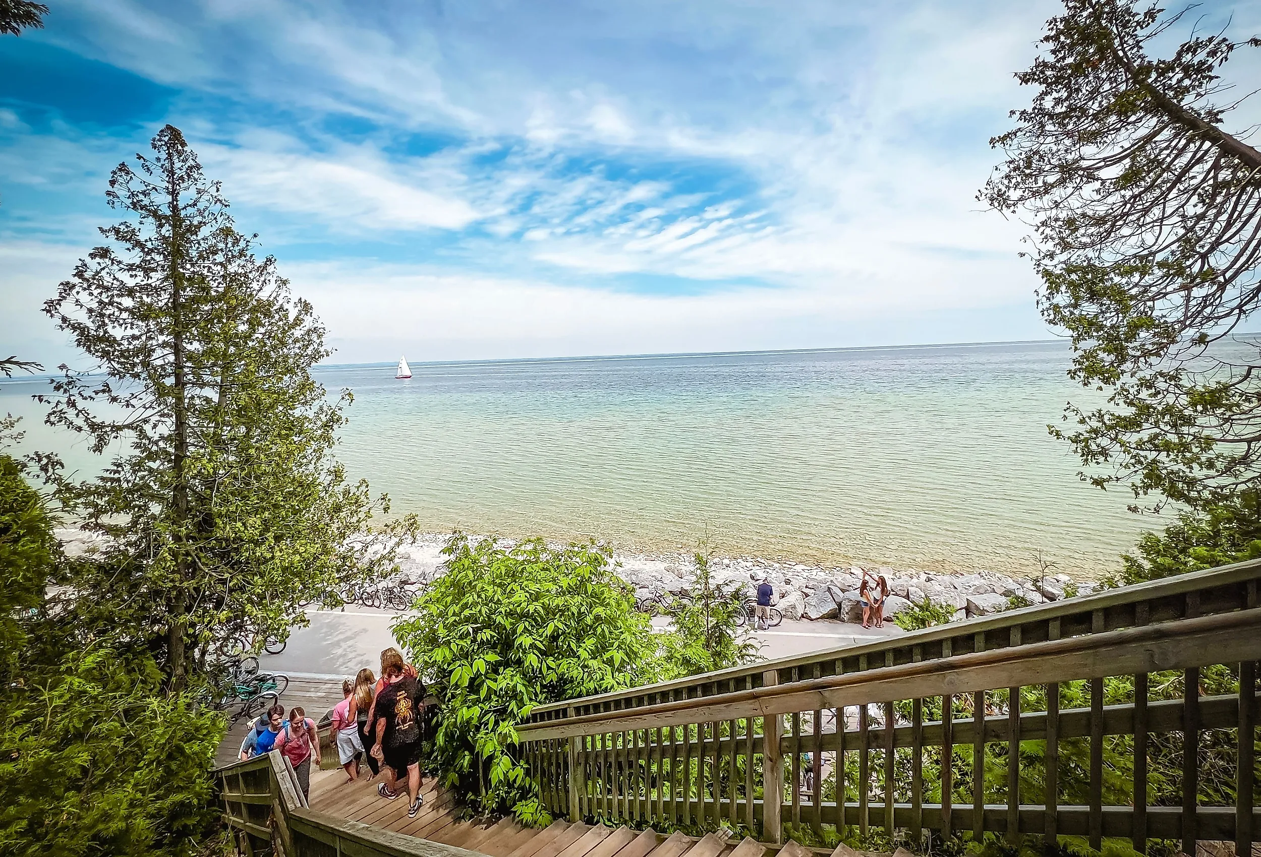
Mackinac Island State Park was established in 1895 (making it Michigan's first state park) and covers over 80% of the island. Though the ferries, Visitors Center, and structures within its purview all have specified hours and seasons of operation, the park itself is open 24/7, year-round. We walkers can utilize the mix of nature trails, paved paths, and quiet roads to discover the gentle woods, tranquil shorelines, and enigmatic rock formations throughout. All told, Mackinac Island State Park's trail network amounts to 70+ miles. With that said, given the island's modest dimensions, regular landmarks, and user-friendly maps/signage, there is no concern of getting lost.

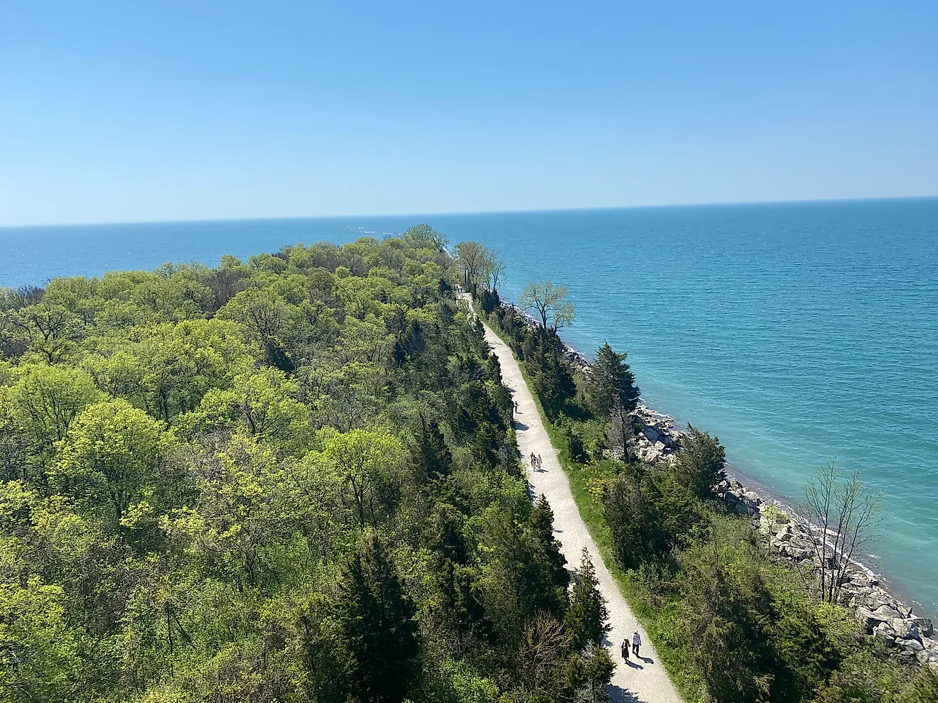
You may wish to simply push north from Fort Mackinac and see what you see, a worthy MO indeed. But if pressed for time, it might help to point your boots toward specific targets. Arch Rock is the obvious crowd-pleaser, and can be accessed via Arch Road or Rifle Range Road (if you're already up the hill), or by climbing the 207 wooden steps up from the east side of the Perimeter Loop (i.e. an extension of Lake Shore Drive). While you're there, pop over to the Milliken Nature Center, which just opened in 2024 and provides more details on Arch Rock and other of Mackinac Island's geological enigmas (such as Sugar Loaf, which stands about a half-mile away).

The east side of Mackinac Island State Park has plenty of other caves, graves, and sweeping viewpoints. But even the more developed west side of the island has highlights such as Sunset Rock (so-called for obvious reasons if you time it right) and Devil's Kitchen (a less obviously named collection of sea (or rather, lake) caves). It is possible to link the main attractions of each hemisphere via the hilltop network. But if time and energy are on your side, you may just want to do a full waterside loop of the island.
Perimeter Loop

Mackinac Island is encircled by a clean-cut, 8.2-mile road. Recall, there are no cars here (save for the odd service vehicle), so this Perimeter Loop is exclusively for walkers, joggers, and cyclists. Assuming you have comfortable footwear, adequate drinking water, and pockets full of the aforementioned fudge, you could tackle the entirety of Mackinac Island in an afternoon. But with that said, after a fulfilling morning of walking around all the previously mentioned attractions, I was happy to double back to the ferry docks and rent a bike for this leg of the journey. After all, Mackinac Island is considered "the bicycle capital of the world," so why not get in on the fun? Doing so shortens the required time to about an hour, including a few photo breaks and interpretive sign sessions.
Make Your Way To Mackinac

Michigan may be known for its automotive legacy, but here on Mackinac Island, no such modern machinery is permitted. Instead, visitors get to rely on old-fashioned forms of locomotion to get around this scenic and historic enclave. Whether you're drawn to the horses, museums, and impressive architecture of the titular town, the stalwart fort above, or the forested trails and natural formations around the periphery, Mackinac Island is worthy of a good long walk.