The Deepest Canyon In Any State Park
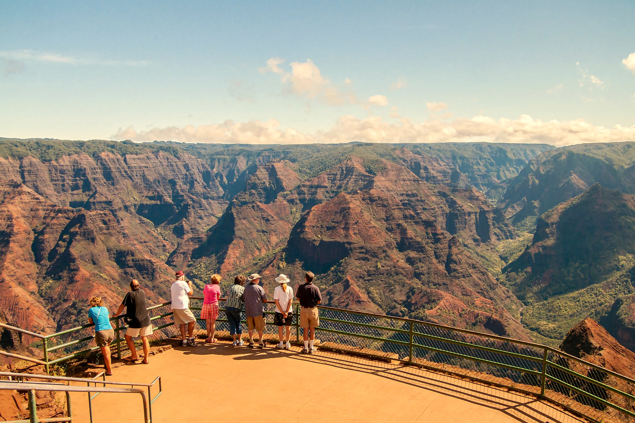
Half a mile is a long way to fall, and at Waimea Canyon on western Kauaʻi you can stand at a guardrail and look straight down that far into red cliffs, narrow ridges, waterfalls, and forested gullies. Hawaiʻi's official tourism site measures the gorge at more than 3,600 feet deep, about 14 miles long, and roughly one mile wide. NASA Earth Observatory gives a matching depth of about 3,600 feet. That dwarfs the famous mainland state-park gorges, including Palo Duro Canyon in Texas, which Texas Parks and Wildlife measures at up to 800 feet, and Tallulah Gorge in Georgia, which the state lists at nearly 1,000 feet. No federal agency ranks every canyon inside every state park, but the published government numbers put Waimea well beyond the best-known contenders.
The Canyon Reaches More Than 3,600 Feet Deep

Stand at the rim, and parts of the Waimea River lie more than half a mile below your boots. GoHawaii, run by the Hawaiʻi Tourism Authority, gives the canyon a depth of more than 3,600 feet. NASA Earth Observatory lands on nearly the same figure, about 1,097 meters. Different rim points return slightly different measurements, because the canyon floor and the surrounding plateau rise and fall along the 14-mile course.
The gap between Waimea and the mainland favorites is enormous. Palo Duro Canyon State Park in Texas reaches about 800 feet at its deepest, according to Texas Parks and Wildlife. Georgia State Parks describes Tallulah Gorge as nearly 1,000 feet deep. Measure Waimea conservatively at 3,600 feet, and its walls still drop more than three times the depth of Tallulah Gorge. Best of all, the road through Waimea Canyon State Park reaches several overlooks where that vertical relief is right there in front of you, no long hike required.
A Volcano Collapsed Here Millions Of Years Ago

The whole spectacle started with a mountain falling apart. Waimea Canyon began inside the remains of an enormous shield volcano, and Kauaʻi itself grew from repeated eruptions that piled basaltic lava thousands of feet above the Pacific floor. USGS studies show that part of the volcano later collapsed, creating a major depression along the island's western side. Fresh lava poured into sections of that lowered terrain, while faults and older volcanic structures stayed buried beneath the later flows. Then erosion took over. Rain draining off Kauaʻi's high interior ran along weaknesses in the rock and cut deep into the old volcanic mass. The Waimea River and its tributaries hauled broken basalt and soil toward the coast, widening and deepening the gorge across millions of years. NASA Earth Observatory ties the canyon's present form to both that ancient collapse and the long erosion that followed, which is why the walls expose such a complicated stack of volcanic rock.
The Cliffs Reveal Thousands Of Feet Of Lava

Some of Waimea Canyon's best numbers are written straight into its walls. USGS geologists mapped roughly 2,400 feet of exposed Nāpali Formation along parts of the western side of the gorge. The Olokele Formation reaches about 2,600 feet in places across other sections. Those formations record different chapters of Kauaʻi's volcanic growth, from thin lava flows laid across the old shield to much thicker deposits that pooled in collapsed areas.
Radiometric dating places parts of the Nāpali Formation at more than four million years old. The canyon cuts through those ancient flows like a giant trench sliced into the island.
You can pick out the difference between layers in the shelves, vertical faces, broken ridges, and darker bands of basalt. USGS researchers have leaned on Waimea Canyon for exactly that reason, because erosion has exposed rock that stays buried everywhere else on the island.
The Famous Red Rock Started As Black Basalt

Here is a fun twist: the canyon's signature color is a disguise. Fresh Hawaiian basalt is dark, but Waimea Canyon has spent millions of years in a wet tropical climate. Water and oxygen altered minerals in the exposed rock and produced iron-rich compounds that turn many slopes rusty red and orange. NASA Earth Observatory points to that weathering of basalt when it describes the canyon's red walls. Green vegetation covers the wetter ledges and gullies, while drier faces stay broad expanses of bare soil and rock.
The color shows up in the name too. Hawaiian place-name references translate Waimea as "reddish water." State environmental documents on the area connect the name with streams carrying red soil after rain. It clicks into place after a storm, when runoff strips loose weathered material off the slopes and funnels it into the drainage below. The same erosion that tints the water keeps reshaping the canyon.
Rainfall Changes By Dozens Of Inches Across The Park

Drive from one end of the Waimea Canyon region to the other, and you practically change climates. Hawaiʻi state planning documents record average annual rainfall of roughly 39 inches near the entrance to Waimea Canyon State Park, about 59 inches around the entrance to neighboring Kōkeʻe State Park, and around 118 inches near Puʻu o Kila Lookout deeper into the highlands. Those sharp swings explain the patchwork of dry red slopes, dense vegetation, wet forest, and running side streams along the canyon road. Water falling on the high interior drains through tributaries that carve narrow ravines into the canyon walls. Heavy rain can also swell waterfalls that run faint or nearly dry in quieter stretches. Waipoʻo Falls, one of the most visible, drops into the canyon near the Canyon Trail and shows up from several roadside viewpoints when the weather cooperates.
The Canyon Road Reaches Several Major Overlooks

You get an outsized payoff for very little effort here. Waimea Canyon Drive climbs away from the dry western side of Kauaʻi and reaches the main viewpoints, so no one has to descend into the gorge for the view. The principal Waimea Canyon Lookout sits near mile 10 and opens across red cliffs, branching valleys, and the deep channel of the Waimea River. Hawaiʻi State Parks manages more viewpoints farther along the road as it continues toward Kōkeʻe State Park.
Clouds can sweep across the upper ridges fast, especially later in the day, so mornings tend to reward early risers. State planning documents describe views toward the Alakaʻi Plateau, Mount Waiʻaleʻale, and parts of Kauaʻi's western and southern coasts on clear days.
The elevation keeps climbing past the main canyon overlook. The road eventually reaches high viewpoints near the Kalalau Valley, where the view changes again into steep green ridges facing Kauaʻi's northwest coast. Waimea Canyon stays behind and below, already thousands of feet deep by the point where the road tops out.
The Kukui Trail Drops About 2,000 Feet

The overlooks show Waimea Canyon from above; on the Kukui Trail you feel every foot of it. Hawaiʻi's Division of State Parks lists the route at about 2.5 miles, rates it difficult, and clocks a descent of roughly 2,000 feet toward the canyon floor. The catch is simple: hikers have to earn almost all of that elevation back on the climb out.
Prefer something gentler? A much shorter option starts near the highway. The Iliau Nature Loop runs only about 0.3 miles and gains roughly 40 feet, according to the state, passing native upland vegetation and opening onto views of Waimea and Waiʻalae canyons.
The Canyon Trail covers about 1.8 miles through the adjoining Waimea Canyon and Kōkeʻe trail network. It crosses Kōkeʻe Stream and reaches the area around Waipoʻo Falls. The route stays well above the deepest part of the gorge, but it runs close to the streams, exposed rock, and sharp-cut side valleys that keep eroding Waimea Canyon today.
A Canyon Still Being Carved
As the deepest canyon in any state park, Waimea sits well ahead of the field, more than tripling Tallulah Gorge and quadrupling Palo Duro, and the depth is only half the story. A collapsing shield volcano opened the ground, and millions of years of Kauaʻi rain finished the job, exposing a stack of lava thousands of feet thick and weathering it red along the way. Visitors can read that whole history from either the rim or the floor, at the roadside overlooks near mile 10 or on the long haul down the Kukui Trail, while the island's rivers keep cutting the gorge deeper.