Touring North America's Deadliest Rockslide
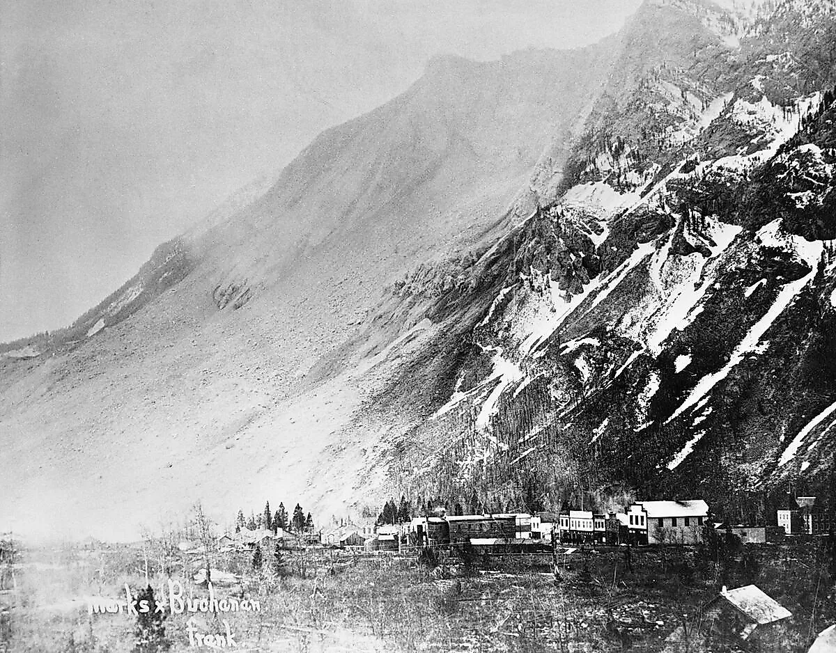
At 4:10 a.m. on April 29, 1903, the north peak of Turtle Mountain in southwestern Alberta broke loose. About 30 million cubic meters of limestone (roughly 82 million tonnes) came down in under 100 seconds, crossed the valley floor, ran up the opposite slope, and buried part of the coal-mining town of Frank under as much as 45 meters of rock. At least 70 people were killed, with some accounts placing the number as high as 90 when transient mine workers and railway laborers are included. Most of the bodies were never recovered. The rubble is still there, Highway 3 still runs across the top of it, and the event is widely regarded as the deadliest rockslide in North American history.

The Town of Frank Before the Slide
Frank sat in the Crowsnest Pass, the main rail and road corridor through the southern Canadian Rockies. The town was founded in 1901 by Henry L. Frank, an American businessman from Butte, Montana, and his partner Samuel Gebo, who together formed the Canadian American Coal and Coke Company. The mine they opened on the eastern flank of Turtle Mountain was producing high-quality bituminous coal within months. Coal was still the dominant industrial fuel in 1901, powering locomotives, ships, and home heating across the continent, and the Crowsnest Pass mines connected directly to the Canadian Pacific Railway mainline that ran past the town.
By 1903 Frank had more than 600 residents, a school, a post office, two hotels, a general store, churches, and the apparatus of a permanent settlement. The mine ran two shifts and was one of the most productive in the Crowsnest field. The town was on a clear trajectory upward when Turtle Mountain came down.
Ninety Seconds

The slide began on the north peak of Turtle Mountain, about 1,000 meters above the valley floor. A wedge of limestone roughly 425 meters wide, 900 meters long, and 150 meters thick released as a single mass and accelerated down the mountain at speeds estimated to have reached 100 kilometers per hour. The rock crossed the valley, ran 120 meters up the opposite slope, and spread across roughly three square kilometers. The roar was heard in Cochrane, about 200 kilometers to the north. The whole event was over in under a minute and a half.
Of an estimated 100 people in the slide's path, at least 70 died. Most were sleeping miners and their families on the eastern side of town. About a dozen bodies were eventually recovered; the rest are still under the rubble. Three buildings (including the Union Bakery, where two families took shelter) were rescued from the edge of the debris. Seventeen miners working the night shift inside the Frank Mine were trapped underground when the entrance was buried, and over the next thirteen hours dug their way out through a coal seam that ran toward the upper mountain. They emerged onto the slide surface to find the town below them mostly gone.
The slide also buried two kilometers of the Canadian Pacific mainline. Sid Choquette, a CPR brakeman who happened to be in the area, ran across the rubble in the pre-dawn dark to flag down an oncoming passenger train and prevent it from running into the debris field at speed. CPR cleared and rebuilt the rail line within three weeks.
Why Turtle Mountain Came Down

A persistent local belief is that coal mining caused the slide. The geology says otherwise. Turtle Mountain is what geologists call a Lewis Thrust formation: an older block of limestone (about 350 million years old) pushed up and over much younger shales and sandstones during the mountain-building events that produced the Rockies. The result is a heavy, fractured slab of limestone sitting on weaker rock that slopes the same direction as the slab. Add the standard erosion forces of tectonic stress, water infiltration, freeze-thaw cycling over millions of years, and the recent action of glaciers that had carved the valley below, and the mountain was already structurally compromised when the town was founded. The coal seams Frank's miners were working did sit at the base of the mountain, and some research suggests that mining may have hastened the failure by a small fraction, but the slide would have come down anyway. The Alberta Geological Survey now monitors Turtle Mountain continuously with a network of sensors, and the south peak of the mountain is considered an ongoing rockfall risk.
Frank After the Slide

The slide did not end Frank. The mine reopened within weeks and the town kept growing. By 1910 the population had reached around 1,000, more than it had been before the disaster. But further geological surveys in 1911 found that the south peak of Turtle Mountain was also unstable and could come down on what was left of the town. The provincial government ordered the residential parts of Frank moved west, and what locals still call "New Frank" was built on safer ground. The old townsite east of the slide was largely abandoned.
The Frank Mine kept operating until 1917, when a labor dispute and continued geological problems shut it down for good. The post-war coal economy never recovered for towns like Frank: the railroads converted to diesel, home heating moved to oil and gas, and the Crowsnest Pass mining boom ended. Frank's population dropped through the 1920s and 1930s and never came back. In 1979, Frank and the other Crowsnest Pass coal towns (Blairmore, Bellevue, Hillcrest, and Coleman) were amalgamated into the single Municipality of Crowsnest Pass. The Frank community area today has a population of roughly 200.
One piece of the original Frank still exists in surprisingly intact form, just not in Crowsnest Pass. The Imperial Hotel, one of the town's main hotels before the slide, was dismantled in 1912 and reassembled 250 kilometers northeast in the central Alberta town of Vulcan, where it became the Vulcan Hotel and operated for most of the twentieth century. The building still stands at the corner of 2nd Avenue and Centre Street, though it is no longer in operation as a hotel.
Visiting the Site

The Frank Slide site was designated a Provincial Historic Resource of Alberta in 1977, and the Frank Slide Interpretive Centre opened on a bluff above the slide in 1985. The centre handles about 100,000 visitors per year and runs exhibits covering the geology of Turtle Mountain, the boom-and-bust history of Crowsnest Pass coal towns, the recovery operations, and individual stories of the dead and the survivors. Admission is modest and the museum is open year-round, with reduced winter hours.

A trail network leads from the visitor centre parking lot directly out onto the rubble field. The main loop, the Frank Slide Trail, runs about 1.5 kilometers across the debris with interpretive signs marking the original locations of buildings, mine works, and rail lines. The walking surface is fragmented limestone (sturdy footwear required), and the trail crosses what was the eastern edge of town before continuing toward the base of Turtle Mountain. The combined visit (museum plus a walk on the rubble) usually runs about two to three hours.
Getting There
Frank sits along Highway 3 in the Crowsnest Pass, about 230 kilometers south of Calgary, 350 kilometers southeast of Banff, and 130 kilometers west of Lethbridge. The Interpretive Centre is signed from Highway 3 just east of the modern Frank townsite. The pass is open year-round, with the road crossing the rubble itself for about a kilometer. The full rubble field is impossible to miss in either direction: a grey-white expanse of broken limestone running from the slumped face of Turtle Mountain across the valley floor and partway up the opposite side, still bare of vegetation after more than 120 years.