This Colorado Scenic Byway Is The Road Trip Of A Lifetime
It's pretty hard to experience all the good stuff Colorado has to offer without dipping into the Rocky Mountains at some point. Well, "what's the best way to go about it?" you may ask. The Top of the Rockies Scenic Byway traces 115 miles through the state's central mountain ranges, connecting locales like Copper Mountain, Leadville, Twin Lakes, Aspen, and Minturn across a series of lofty passes. Colorado designated the route a "Scenic and Historic Byway" in 1993, followed by National Scenic Byway status in 1998. But its current layout took shape with a 40-mile (64 km) extension in 2009 between Twin Lakes and Aspen over Independence Pass, ultimately following portions of U.S. Highway 24 and State Highways 91 and 82, and crossing the Continental Divide at Fremont Pass and Tennessee Pass, too.
Along the way, you'll drive beneath Mount Elbert and Mount Massive, Colorado's two highest peaks, and follow the Arkansas River near its headwaters. As you can imagine, elevations remain high throughout, rising to over 12,000 feet at Independence Pass and linking several major mountain valleys across Lake, Summit, Eagle, and Pitkin counties.
If that already sounds interesting, here is a rundown of some of the best sights and sounds to check out while traveling the "Top of the Rockies," from historic roadside stops to epic natural landmarks and more.
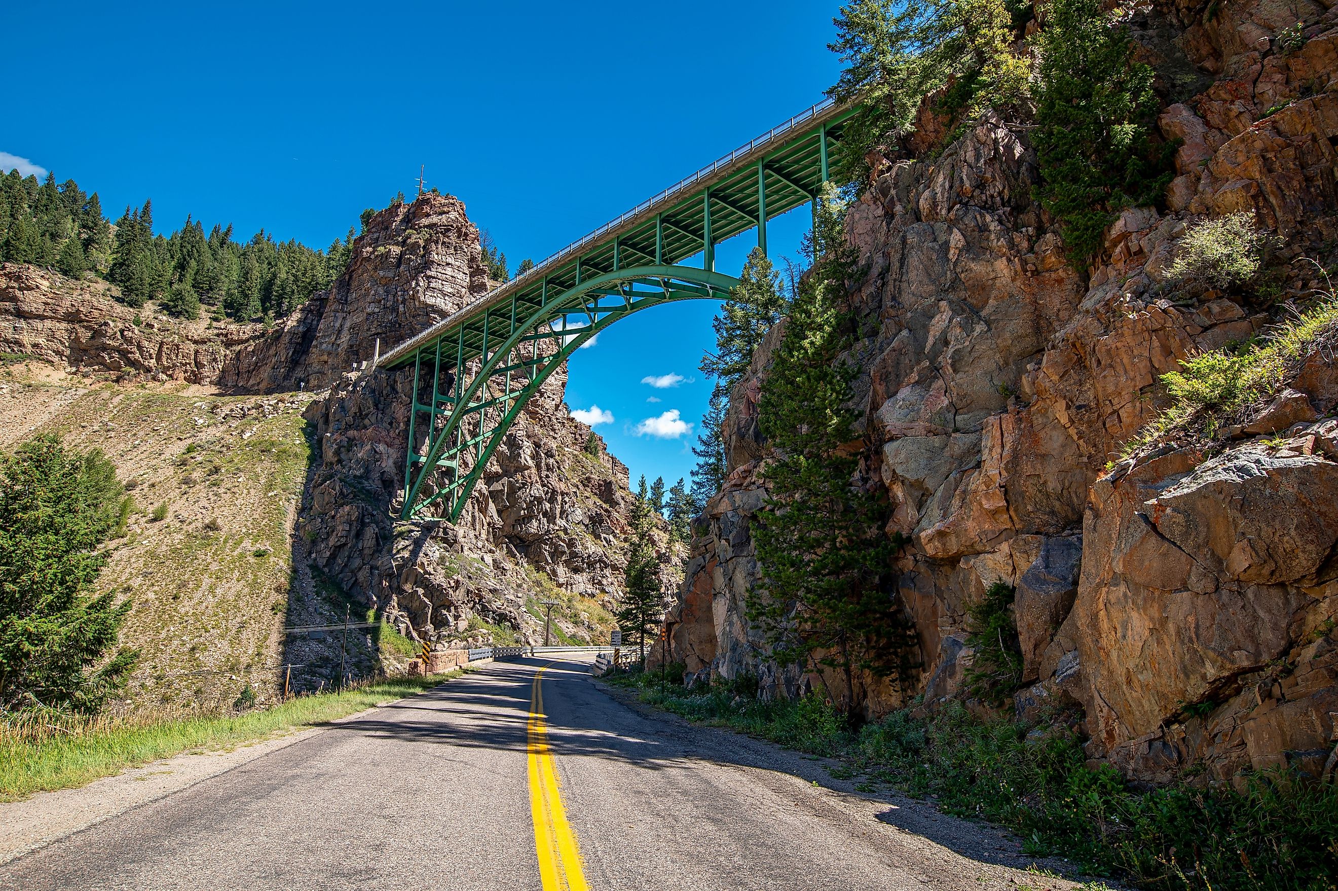
Red Cliff & Green Bridge Overlook

Red Cliff & Green Bridge Overlook provides a quick introduction to the rugged terrain you experience on the way if you're beginning the journey around Vail. Located near the small community of Red Cliff, the overlook peers into the narrow Eagle River canyon, where steep, forested slopes rise above the river. The Green Bridge, a distinctive steel structure dating back to 1941, is a favorite among architectural enthusiasts and is visible from the viewpoint.
Red Cliff itself began as a mining settlement in the late 1800s, and remnants of that history remain in the surrounding mountains for you to see today. Overall, this spot makes a useful roadside stop before continuing toward Tennessee Pass and Camp Hale, even if you just need a rest.
Camp Hale-Continental Divide National Monument

Camp Hale-Continental Divide National Monument protects a high-elevation valley west of Leadville with a distinctive military history. The U.S. Army established the camp in 1942 to train the 10th Mountain Division for combat in mountainous terrain during World War II. Here, soldiers practiced skiing, climbing, and winter warfare before deploying to Italy, ultimately shut down in 1945 with the conclusion of the war.
Now, the former campsite still contains remnants of its military past, including old building foundations, roads, and interpretive signs explaining the soldiers' training. The monument also encompasses forests, alpine terrain, and portions of the Continental Divide that you can hike in.
Designated by presidential proclamation in 2022, it covers more than 53,800 acres and conveniently sits directly along the Top of the Rockies Scenic Byway.
Leadville

At 10,200 ft (3,109 m), Leadville is the highest incorporated city in the United States and a major historic settlement along the byway. The city grew rapidly after the discovery of rich silver deposits in the late 19th century, leaving behind landmarks such as the Tabor Opera House and Healy House Museum & Dexter Cabin.
Try dropping by the National Mining Hall of Fame and Museum, which explores Colorado's mining industry through numerous detailed exhibits, artifacts, and well-kept historic equipment. Leadville also sits between some of the state's highest peaks, including Mount Elbert and Mount Massive, allowing it to be a useful base for exploring the surrounding high country should you want to do some hiking or skiing.
Mayflower Gulch

A neck of the Top of the Rockies byway near Leadville goes back north, up to Copper Mountain. If you choose to go this way, you can drop by the Mayflower Gulch, a high-alpine valley that is superb for hiking. A trail into the gulch follows an old mining road toward the remains of the Boston Mine, where weathered structures sit beneath the dramatic slopes of the Tenmile Range. This area is also generally known for its broad views of surrounding peaks and colorful alpine terrain, particularly in summer and early fall.
The trailhead sits at roughly 11,000 ft (3,350 m), so note that conditions can change quickly and snow can linger well into summer. But if you manage to catch some good weather, Mayflower Gulch combines remote Colorado mountain scenery with more tangible evidence of the region's mining history, making it a highly distinctive destination should you make the detour.
Twin Lakes

Twin Lakes is a pair of connected alpine reservoirs surrounded by the Sawatch Range, with Mount Elbert rising prominently to the north. The lakes sit right along the road between Leadville and Independence Pass, making them yet another natural stop for amazing mountain views and photography.
Here, you can walk beside the shoreline, fish, or explore the nearby Twin Lakes Historic District. This district also includes the remains of Interlaken, a former resort established in the 1880s on the lakeshore. Moreover, nearby lookouts offer sightlines toward snow-capped peaks, often marking the transition from the broad Arkansas River Valley toward the steep climb up the famed Independence Pass.
Independence Pass

At 12,095 ft (3,686.5 m), this pass is the highest point on the Top of the Rockies Scenic Byway and easily among Colorado's most dramatic mountain crossings. Following the historic path of the Independence Pass wagon road, the route connected various mining communities around Leadville with Aspen and beyond.
As said before, the road to it climbs from Twin Lakes over the Continental Divide before descending toward Aspen, passing through alpine terrain above treeline. Several pullouts provide yet more views across the Sawatch Range, while the summit area has a short paved walkway and information about the area's history.
Keep in mind that it is typically closed during winter because of heavy snowfall and avalanche hazards, reopening when conditions allow in late spring or early summer.
Aspen
Aspen marks the western end of this already magnificent byway, reached after multiple ascents and descents from several scenic passes through the upper Roaring Fork Valley. Like many communities in the region, this city began as a silver-mining settlement in the late 1800s, and several notable historic buildings still happen to remain from that period, including the Wheeler Opera House and Hotel Jerome.

These days, Aspen is best known for its ski resorts and accommodations, including Aspen Mountain, Aspen Highlands, Buttermilk, and Snowmass. On the other hand, summer makes the surrounding mountains open up for hikers and cyclists, with plentiful access to a number of incredible routes, while the Maroon Bells, one of Colorado's most recognizable mountain scenes, lie just southwest.
See what Makes this Route the Best Way to Experience Colorado
The Top of the Rockies Scenic Byway brings together exciting mountain passes, historic mining communities, alpine lakes, and some of Colorado's grandest peaks into one amazing adventure. Whether starting in Vail, Copper Mountain, or Aspen, the trip is best experienced slowly over the course of several days, giving you much-needed time for stops along the way.