This California Scenic Byway Is The Road Trip Of A Lifetime
Big Sur is the rare drive that earns every superlative thrown at it. The 72-mile run of Highway 1 clings to a shelf blasted into the Santa Lucia Mountains. On your right the slopes climb into chaparral and redwood. On your left the Pacific drops away for hundreds of feet. The road was a genuine feat to build here. Every stop along it is a different answer to the same hard question of how people crossed this coast at all.
The federal government made it official in 1996 and named this stretch an All-American Road. You can drive it end to end in about 90 minutes. Do that and you will have missed the point. Plan on five hours or a full day, because the turnouts are where the coast reveals itself. What follows are the stops worth pulling over for, roughly north to south.
Bixby Creek Bridge

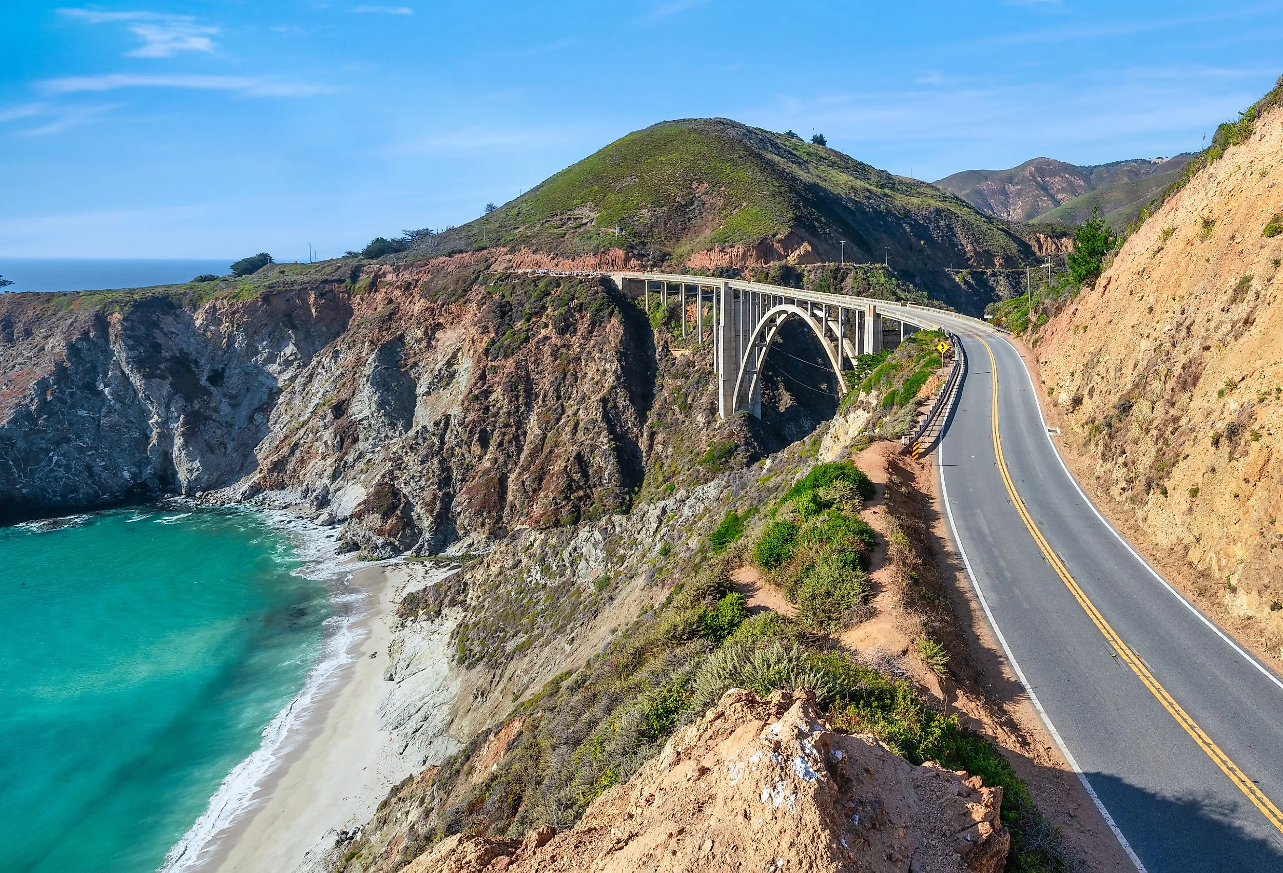
About 15 miles south of Carmel, the highway rounds a bend and the whole postcard opens up at once. Bixby Creek Bridge carries the road 260 feet above a gorge where the creek runs down to a small cove. Turkey vultures ride the updrafts below the deck, and you can watch them from the bluff on the north side. This is the start of the most photographed stretch of the entire route, and it lives up to the reputation.
The engineering still impresses nearly a century on. The reinforced-concrete arch runs 714 feet long, with a main span of 320 feet that was the longest of its kind on the state highway system when it opened. Crews finished the structure in October 1932 and opened it to traffic that November. Stopping on the bridge itself is not allowed. The views of the Pacific and the cove below come from the pullouts at either end, so aim for those.
Point Sur Lighthouse

A few miles farther south, a dark volcanic rock rises 361 feet straight out of the surf. A low sandbar ties it to the mainland and keeps it from being a true island. To build here at all, workers blasted 80 feet off the summit in the 1880s just to make a level pad. The sandstone lighthouse they raised was first lit on August 1, 1889, and it has never gone dark since. Guided walking tours run several days a week, and they are the only way onto the rock.
The headland is a small world of its own. Brandt's cormorants and western gulls nest on the steep volcanic faces, and sea lions haul out on the rocks at the base. Gray whales pass through the offshore kelp beds on their winter and spring migrations. Fog is the local specialty here. It pools in the low ground on either side of the point while the summit often stays clear above it, so the lighthouse can float over a bank of cloud.
Andrew Molera State Park

Just south of the lighthouse the road drops into the wide valley of the Big Sur River. At nearly 5,000 acres, Andrew Molera is the largest undeveloped coastal basin on the whole corridor, and it feels like it. The river wanders across open floodplains before it reaches the ocean through a belt of vegetated dunes. Beach sagewort and dune scrub hold the sand in place. That cover shelters the federally threatened western snowy plover, which nests on ground most people would walk right past.
Fifteen miles of trails thread the park. The two-mile Creamery Meadow Trail crosses the river on a seasonal footbridge to reach the beach, and the 1.7-mile Bluffs Trail runs the headlands with the water always in view. History sits near the entrance too. The Cooper Cabin, built in 1861 of hand-hewn redwood, is the oldest building in Big Sur. The Molera Ranch House Museum and the California Condor Discovery Center round out the stop, so you can trade the trail for the region's story without much of a walk.
Pfeiffer Big Sur State Park

Turn inland at Pfeiffer Big Sur and the temperature drops the moment the redwood canopy closes overhead. Sunlight reaches the forest floor in scattered coins, filtered through branches that start well over a hundred feet up. The Big Sur River runs through the valley and is usually the loudest thing in the grove. After the exposed cliffs to the north, the shade comes as a genuine relief.
This 1,006-acre park sits at the southern edge of the coast redwood's (Sequoia sempervirens) natural range. It protects rare old-growth pockets that outlasted 19th-century logging, and the Old-Growth Forest Network has formally recognized the stand. The headliner is the Colonial Tree, an ancient giant estimated at 1,100 to 1,200 years old. It was already centuries into its life when the first Spanish ships sailed this coast.
The hiking pays off fast. The two-mile Pfeiffer Falls and Valley View loop climbs through oak and redwood to a 60-foot waterfall spilling over mossy rock. A branch keeps going another 500 feet up to an overlook, where the trees finally break and you can see clear back to Point Sur and Andrew Molera. It is the best free view in the park.
Pfeiffer Beach

Watch for Sycamore Canyon Road about a mile south of the park entrance. It drops 2.2 narrow miles to Pfeiffer Beach, one of the few places on this coast where the highway lets you reach open water. The wind here almost never quits, and it blows loose sand clear across the parking lot. Come after a rain and you get the payoff. Streaks of deep purple appear in the sand where manganese garnet, washed down from the hillsides, settles among the paler grains at the tideline.
Offshore stands Keyhole Rock, a sea stack with a window worn clean through its middle by the waves. For a handful of evenings around the winter solstice, the setting sun lines up with that opening and fires a beam straight through it onto the beach. Photographers line up hours early for it. The access road is so narrow that only five points along its length let two cars pass, so take your time on the way down.
Nepenthe

Three miles south of Pfeiffer Big Sur, the coast opens up again at Nepenthe, a restaurant carved into the hillside 800 feet above the water. Orson Welles and Rita Hayworth bought the old cabin here in 1944 as a romantic getaway and never moved in. Bill and Lolly Fassett bought the land from them and, in 1949, opened the restaurant that stands today. They hired architect Rowan Maiden, a student of Frank Lloyd Wright, who built it of local redwood and native stone so it would settle into the slope rather than sit on top of it.
The draw is the same one that has pulled travelers up here for 75 years. You sit on the open deck among heavy timber beams and iron braziers and look out over miles of the Santa Lucia range dropping straight into the Pacific. It is the elevated version of the coast you have been driving beside all day. From up here the dark headlands and the shifting blue kelp beds line up one after another, and you finally see how the whole thing fits together.
Partington Cove

Six miles south of Nepenthe, a modest turnout inside Julia Pfeiffer Burns State Park marks the trailhead for Partington Cove. This one rewards the effort. A short one-mile round trip drops 300 feet down a steep dirt road that follows Partington Creek to the water. At the bottom the trail crosses a wooden footbridge and forks. Bear left and you land on a rocky beach where the creek meets the Pacific.
Bear right and the trail runs you through a 60-foot tunnel hand-carved through solid rock in the 1870s. John Partington cut it to haul tanbark and timber down to schooners waiting in the cove. Cargo went out on cable systems from a bench of exposed rock that still juts into the sea. The whole operation is long gone, but the tunnel remains a small monument to how much work it took to move anything off this coast. The cove is now part of the Monterey Bay National Marine Sanctuary, its water clear and deep over rocky kelp beds.
Salmon Creek Falls
Near the southern end of the byway, roughly five miles before it hands off, Salmon Creek Falls gives you the easiest waterfall payoff on the whole drive. A quarter-mile trail leaves a roadside turnout and heads inland through a canyon shaded by bay laurel and coastal live oak. You can follow the sound of the water most of the way in.
The trail ends at a broad granite pool where Salmon Creek splits into two chutes and drops a combined 120 feet down a sheer face. The canyon walls are Franciscan Complex rock, scraped and folded up by ancient tectonic subduction along the edge of the Pacific plate. For those with more time and stronger legs, the Salmon Creek Trail climbs from here into the Silver Peak Wilderness, linking the coastal chaparral to high pockets of pine and redwood far above the road.
Why This Drive Stays With You
String these stops together and the coast starts to make sense as one connected place. The bridge and the tunnel are human answers to the same steep terrain. The river mouth, the redwood canyon, and the purple beach are the natural ones. Point Sur and Bixby show the sheer effort it took to cross and light this shore in the first place. The state parks protect what the logging and the road builders left behind. That is the real reward of driving Big Sur slowly. You stop seeing a string of viewpoints and start seeing how a mountain range, an ocean, and a stubborn ribbon of highway learned to share 72 miles of the same edge.