8 Most Scenic Drives in New Zealand
The alpine scenery of Crown Range Road, the rainforest valleys of Haast Pass, and the volcanic landscapes along the Desert Road reveal why New Zealand is considered one of the world's premier road-trip destinations. Compressed into two islands roughly the size of Colorado, it contains an improbable variety of terrain from active volcanoes, temperate rainforests, braided glacial rivers, open tussock plateaus, fjords, and thousands of kilometers of coastline. These drives highlight that variety, each offering a different perspective on the country's remarkable scenery.
Milford Road (State Highway 94)

Milford Road is widely regarded as one of the finest mountain drives on earth. Leaving Te Anau, this section of the route spans 119 kilometers along the eastern shore of Lake Te Anau before pushing north into the Fiordland wilderness. The first stretch out of Te Anau passes Mirror Lakes, roadside pools so still they reflect the Earl Mountains. The road then enters Fiordland National Park and follows the Eglinton Valley, a broad glacial trough lined with silver beech forest. At the Knobs Flat junction, the valley narrows, and the Hollyford Track signals a shift in the surrounding rock faces. The Divide is one of the lowest alpine crossings in the Southern Alps. The route then enters the Homer Tunnel, a raw, unlined rock tunnel that drops steeply before emerging above the Cleddau Canyon. The descent from the tunnel along the canyon edge, with waterfalls threading the canyon walls beside the road, is the most dramatic section of the drive. The road ends at Milford Sound village.
Winter snowfall can close the Homer Tunnel without notice, and it's best to check the NZ Transport Agency road status before departure. The tunnel operates on a light-controlled one-way system, and queues can build to 30 minutes on busy summer days. The road beyond the Eglinton Valley is sealed but narrow and not suitable for large caravans. Allow 2.5 to 3 hours of driving time with stops.
Forgotten World Highway (State Highway 43)

State Highway 43 traces the old Māori travel route across the central North Island interior, threading through remote hill country for over 145 kilometers. The landscape is unlike the polished scenery of the tourist circuit. It is rugged, grassy, and often foggy, with volcanic peaks appearing through breaks in the rolling hills. Many tunnels, including the single-lane Moki Tunnel, cut through rock ridges in a stretch with no fuel or phone service.
Departing Stratford on the Taranaki Plains, the road leaves the Mount Taranaki foothills and begins climbing into the Forgotten World. The Tangarakau Gorge is the centerpiece of the middle section. The tiny settlement of Whangamomona, with its historic hotel, marks the informal halfway point. Beyond it, the terrain opens into cattle-farmed hill country descending gradually toward the Whanganui River valley at Taumarunui. No fuel is available between Stratford and Taumarunui, so fill up before departing. The Moki Tunnel is one lane and requires drivers to yield at either end, so check for oncoming traffic. Summer and early autumn (December through April) generally offer the clearest weather and best driving conditions, although morning fog can still occur in the hill country. Allow a full day to cover the route properly.
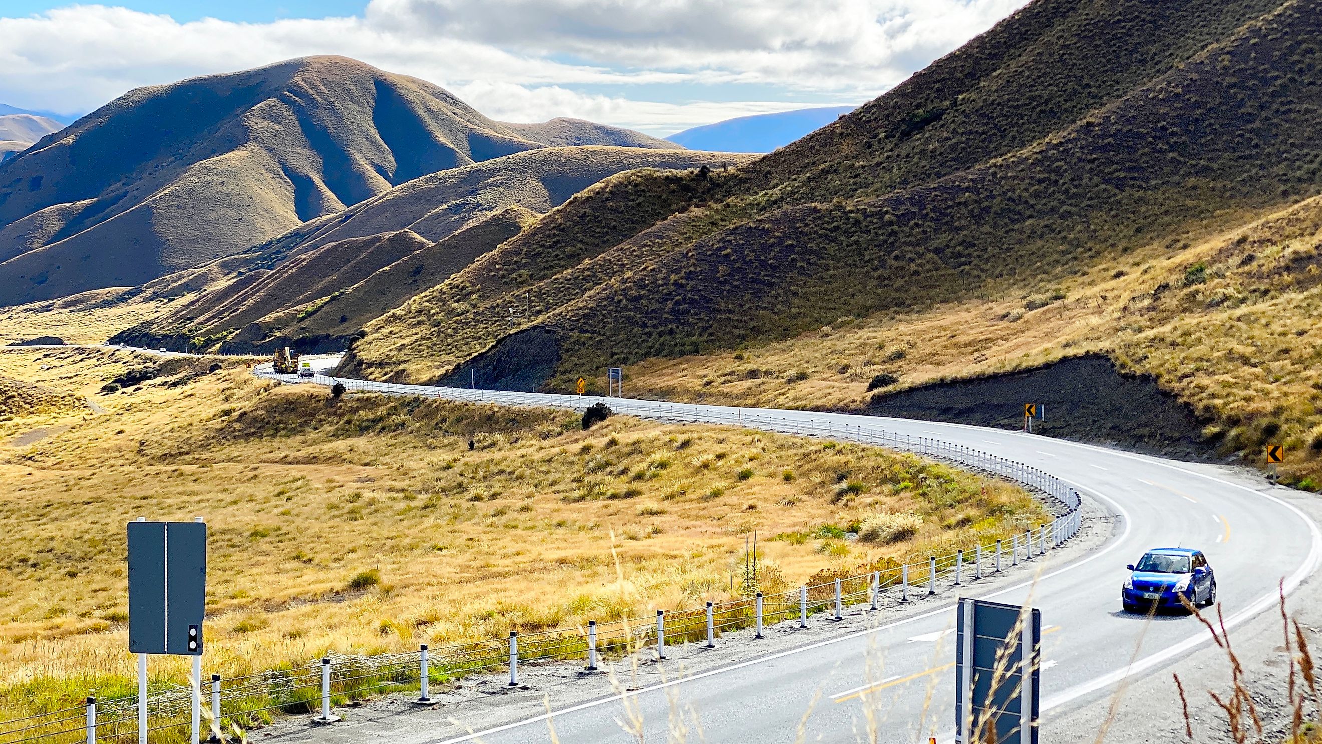
Lindis Pass (State Highway 8)

This Lindis Pass route along State Highway 8 spans around 80 kilometers, a primary inland crossing between the Mackenzie Basin and the Queenstown-Lakes region. The tussock-covered hills are almost entirely treeless, giving the pass an exposed, wide-open quality that contrasts sharply with the forested routes of Fiordland or the Coromandel. The pass summit sits at 971 meters and offers views back across the Ahuriri Valley and forward to the Clutha River basin.
From Omarama, the road follows the Ahuriri River through a wide riverbed flanked by pale tussock slopes. As the valley narrows, the climb to the pass begins through hills that take on a golden hue in afternoon light. The summit provides a clear viewpoint from a small pull-off on the western side. The descent into the Tarras Basin brings the road back alongside a tributary of the Clutha River, with views across the valley floor toward the Dunstan Mountains. The pass is prone to snow and black ice in winter, and occasionally closes for short periods. In summer, the route can carry high volumes of camper van traffic. No services exist between Omarama and Tarras.
Coromandel Coastal Road (State Highways 25 and 25A)

The Coromandel Peninsula's road system wraps for roughly 85 kilometers via the coastal route around a mountainous spine dropping sharply into the Pacific. Along the eastern coastal route, the road alternates between dense forest on steep hillsides and views across the Mercury Bay and Firth of Thames. Heading north out of Thames, SH25 follows the Firth of Thames coastline with mangrove flats and mudflat birdlife before the road begins climbing the peninsula. At Coromandel town, the road curves east and the Pacific appears ahead across a landscape of pohutukawa-lined bays. The route through Kuaotunu is the most visually dramatic stretch. Whitianga's harbor mouth marks the end of the coastal segment. Here, one can also head out to Cook’s Beach or the Shakespeare Cliff Lookout to stretch their legs and take in the views of Mercury Bay.
Those returning via SH25A cross the range through dense regenerating kauri forest on a series of tight switchbacks before dropping back to the Thames coast. The narrow sections north of Coromandel town are challenging for large vehicles. The route can be busy at peak summer holiday periods (late December through January). Allow a full day if driving both coasts and crossing the range.
Crown Range Road (State Highway 89)

State Highway 89 over the Crown Range is New Zealand's highest sealed state highway, peaking at around 1,100 meters. It is also the most direct road between Wanaka and Queenstown, though the views justify the detour even when time is short. The summit opens up a panorama across the Wakatipu Basin, revealing the Remarkables and Cecil Peak across the lake 1,000 meters below. Leaving Wanaka, the road climbs through open tussock country above the Cardrona Valley, passing the Cardrona skifield turn-off midway up. The summit plateau is wide and exposed, with the Pisa Range visible in the distance. The Crown Range Road Scenic Lookout near the crest offers a direct view of Queenstown and Lake Wakatipu. The descent zigzags sharply through tussock and schist rock faces before the road straightens into the Gibbston Valley wine country, where terraced vineyards occupy the gorge walls alongside the Kawarau River.
The summit road closes frequently in winter due to snow and ice, and ice can form overnight without warning. Chains may be required in winter. The road is narrow with some tight corners. Allow 1.5 hours from Wanaka to Queenstown with stops.
Kaikōura Coast (State Highway 1)

The central section of State Highway 1 between Blenheim and Christchurch squeezes between the Seaward Kaikōura Range and the Pacific Ocean in one of the most compressed coastal landscapes in New Zealand. For roughly 90 kilometers, the mountains rise almost directly from the shoreline. The contrast of snow-capped peaks, grey-blue ocean, and wave-cut limestone platforms creates scenery found nowhere else in the country. South of Blenheim, the road descends through the Waihopai valley before reaching the coast north of Ward. From there, the shoreline drive begins, with seal colonies occupying the rocky ledges below the road in multiple locations south of Ohau Point. The Kaikōura Peninsula comes into view as the mountains crowd closer, with the Seaward Kaikōura Range towering directly above the town. South of Kaikōura, the Hundalee Hills section lifts the road briefly above the coast before the long descent into the Canterbury Plains north of Christchurch.
Winter southerly storms can make the exposed coastal stretch rough. The road was severely damaged in the 2016 Kaikōura earthquake and has been rebuilt, though some sections remain on temporary alignments. Seals on the road verge are a genuine hazard near Ohau Point, and the route carries heavy truck traffic. Allow 4 to 5 hours and over 300 kilometers from Blenheim to Christchurch with stops.
Desert Road (State Highway 1, Tongariro Plateau)

The Desert Road crosses the volcanic plateau of the central North Island, passing within close view of the active volcanoes Ruapehu, Ngāuruhoe, and Tongariro. The terrain has almost no trees, giving drivers the unsettling impression of driving across another planet. On a clear day, all three volcanoes are visible from the road at once, and in winter their cones are capped with snow above the brown plateau floor. From Waiouru, the road rises steadily onto the plateau, and the military base fence-line gives way to open tussock. Mount Ruapehu appears first to the west, its summit crater often steaming. The roadside Lake Moawhango vista opens briefly before the route crests, and the views of Ngāuruhoe volcano appear directly ahead. The Rangipo Desert stretches east of the highway with its red-brown soil. The road descends from the plateau into the Tongariro River valley at Turangi, where the landscape returns abruptly to green farmland.
The Desert Road closes regularly in winter due to snow and ice, and is the most frequently closed main highway in the North Island. Check NZTA road closures before traveling in the winter. Wind across the plateau can be severe. The road is sealed, straight, and in good condition in summer. Allow 1.5 hours with stops.
Haast Pass/Haast Highway (State Highway 6)

Haast Pass is the southernmost road crossing of the Southern Alps in New Zealand, and the only sealed road connecting the West Coast to the Otago interior for several hundred kilometers. The drive traverses two entirely different climates and ecosystems in a single journey. Leaving Wanaka, SH6 follows Lake Hawea briefly before cutting through a narrow gorge at The Neck. The road then tracks the Makarora River into Mount Aspiring National Park, where the valley walls close in and beech forest replaces open grassland. The Gates of Haast mark the entry to the steepest section, where the Haast River drops through a series of boulder chokes visible from several roadside viewpoints. West of the summit, Fantail Falls and Thunder Creek Falls drop just off the road. The road then follows the Haast River to the coast, flattening into a sea-level run through kahikatea swamp forest to the village of Haast.
Haast Pass rarely closes due to snow, but the western approach can flood after heavy rain, which is frequent. The Haast River valley is exposed to westerly weather systems, and rainfall on the coastal side can exceed 4,000 mm annually. The road narrows considerably in the gorge sections and is not suitable for large vehicles on the western approach. Allow 3 hours from Wanaka to Haast with stops.
Drive Through New Zealand
These eight most scenic drives in New Zealand offer a cross-section of everything that makes the country's landscape remarkable. They cover both islands, both coasts, the volcanic interior, the alpine spine, the far south, and the remote west. The country's Department of Conservation and NZTA both maintain real-time road status tools that take less than a minute to check. The drives listed here are best when driven slowly, to let the landscape settle and understand what you are actually looking at. The mountains, the fiords, and the volcanic plateau are not scenery that improves with rushing.