8 Great Road Trips to Take in Georgia
Georgia’s road network stretches from the Blue Ridge Mountains in the north to the Atlantic barrier islands and salt marshes in the south. That geographic range makes the state ideal for road-tripping, whether you want a quick 18-mile drive from Savannah to Tybee Island or a longer adventure through places like Providence Canyon and the Okefenokee. The eight road trips below are among the South’s most rewarding, combining spectacular scenery with the history and character that make Georgia so memorable.
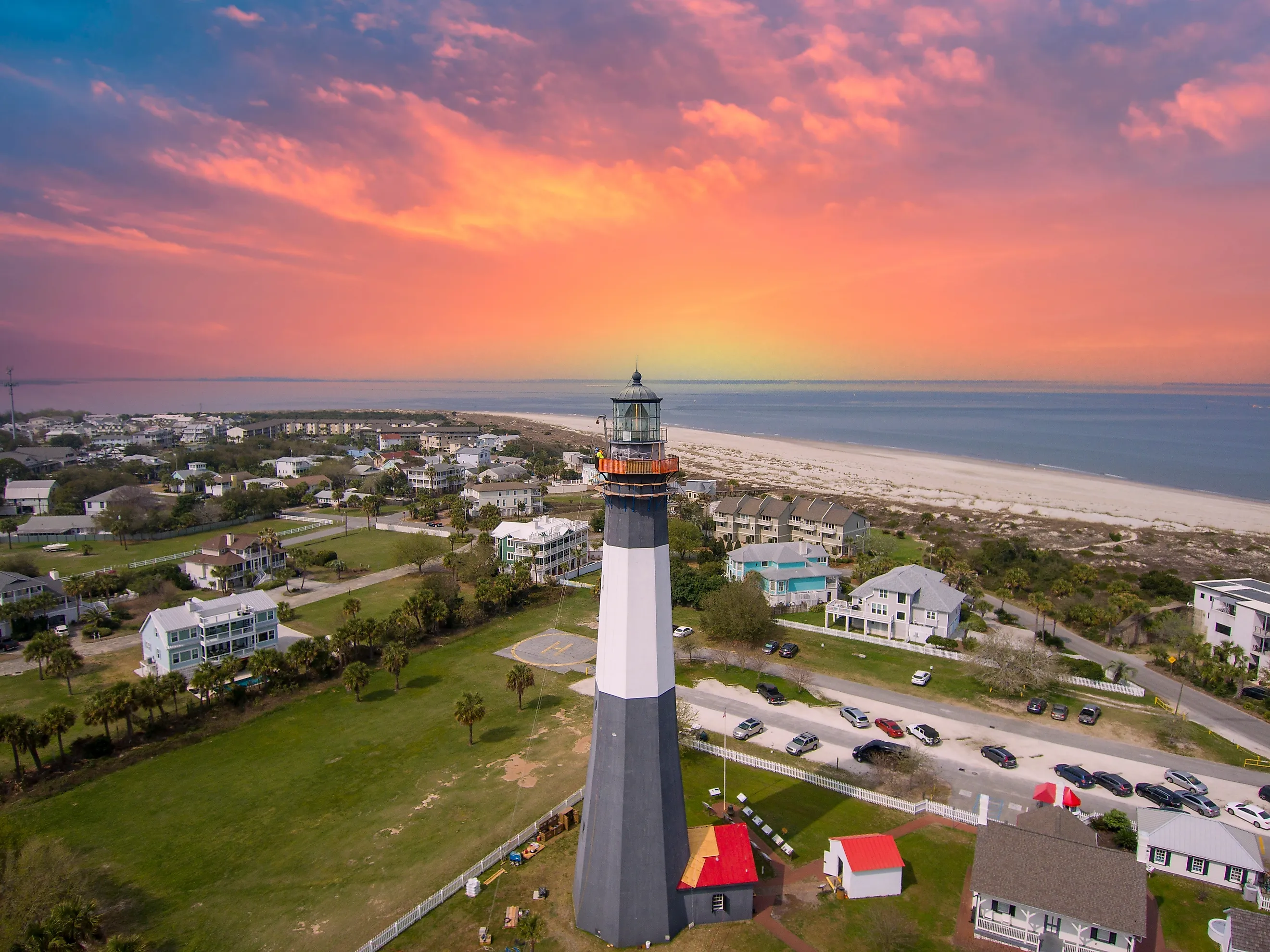
Savannah to Tybee Island

From Savannah's historic district, US-80 East runs 18 miles to Tybee Island, crossing the Bull River and Lazaretto Creek causeways. The drive takes roughly 30 minutes without traffic, though summer weekends are considerably busier as you approach the coast.
The route passes through salt marsh terrain, and at low tide, the exposed mudflats along the causeways are worth a slow drive to admire the scenery. The Tybee Island Lighthouse is open to the public and offers a stunning view of where the Savannah River meets the Atlantic Ocean. If you feel like enjoying the salty breeze, consider booking a tour with Captain Derek's Dolphin Adventure Tours to spot bottlenose dolphins and explore Tybee Island's historic coastline.
Keep in mind that summer beach traffic peaks in July and August as visitors arrive from all over the state and its surrounding regions. Arriving early in the morning helps avoid the heaviest traffic.
Atlanta to Tallulah Gorge State Park

The drive from Atlanta to Tallulah Gorge runs about 105 miles northeast via US-23/441, passing through the town of Clayton before dropping into the gorge. Taking around 2 hours without stops, the route climbs gradually through the Piedmont into the Blue Ridge Mountains, where the terrain transitions into rolling hills and lush forests around Cornelia.
Tallulah Gorge itself is roughly 2 miles long and nearly 1,000 feet deep. The South Rim Trail (1.6 miles) can be accessed without a permit and offers a stunning view of the gorge. You can descend the 310 steps to the suspension bridge at the bottom for even more amazing views. The falls, including Oceana Falls and Tempesta Falls, run stronger in late winter and spring when water is released over Tallulah Dam.
Cumberland Island National Seashore

Cumberland Island is accessible only by ferry from St. Marys on the state's southern coast near the Florida border. St. Mary's sits about 340 miles, or 5 hours, from Atlanta via I-95 South and GA-40 East. The ferry crossing takes 45 minutes each way and reservations are strongly advised as walk-on spots fill up quickly. The morning ferry departs St. Mary's around 9 a.m., and the last return ferry leaves the island in the late afternoon, giving you roughly six hours to explore the island.
No cars are allowed once you're on the island, so park your vehicle and explore the 17-mile-long island, which has 50 miles of trails running through maritime forest, freshwater ponds, and open beach. Wild horses roam freely and are commonly seen along Dungeness Roadways and the beaches. Overnight camping is available at Sea Camp and at four camping sites throughout the island. Visitors should bring their own water and food, as there are no stores on the island.
The Russell-Brasstown Scenic Byway

The Russell-Brasstown Scenic Byway is a 41-mile loop in the Chattahoochee-Oconee National Forest in northeast Georgia, accessed from Helen via GA-75 North. The loop combines GA-180, GA-180 Spur, and GA-348. GA-348 (the Russell Highway) is the main section of this trip, climbing through the Raven Cliffs Wilderness and crossing Tesnatee Gap. The road is very narrow in sections and not recommended for large RVs or trailers.
GA-180 Spur branches off toward Brasstown Bald, the highest point in Georgia at 4,784 feet. Stop at Brasstown Bald and take the half-mile walk to the summit observation deck for a sweeping view of the surrounding mountains. In the winter months, sections of the GA-348 might be closed due to weather conditions. Anna Ruby Falls, a short detour off GA-356 near Unicoi State Park, is a must-see in the warmer summer months.
The Antebellum Trail

The Antebellum Trail is a 100-mile designated route connecting the cities of Athens and Macon through a string of Georgia towns that survived the Civil War largely intact. Full of historic sights and local museums, the route runs US-129 South through Watkinsville, Eatonton, Milledgeville, and on to Macon, with some segments on US-441.
If you don't stop, the drive takes around two hours, though most travelers spend a full day on the route because of the many places to stop. Milledgeville served as Georgia's capital before Atlanta; the Old Governor's Mansion, built in 1839, is open for tours and displays the antebellum capital's storied history.
Expect to see well-preserved 19th-century architecture and a connected historical narrative across all the stops on your journey. While much of the drive is through small-town Georgia with gas stations and fast food alongside historic districts, there are plenty of interesting views along the way.
The Georgia Highway 3 (US-41)

US-41 runs about 2,008 miles from Miami, Florida to Michigan’s Upper Peninsula (and 387 miles through Georgia), bisecting the state north to south. The Georgia stretch passes through Dalton, Calhoun, Cartersville, Marietta, Atlanta, Griffin, Forsyth, Macon, Cordele, and Tifton. The road passes through the commercial strips and town squares of US-41 that were built up around it in the mid-20th century.
There's plenty to see along the route. In Cartersville, discover the Etowah Indian Mounds State Historic Site, which is just a few miles off US-41. Macon's stretch of the route runs through the downtown area near the Ocmulgee Mounds National Historical Park, another significant archaeological site. South of Macon, the road flattens into south Georgia farmland through cotton and pecan groves to the Tift and Lowndes counties. The drive is all about discovering the state's history and how its influences extend into our present day.
Providence Canyon State Park

Providence Canyon State Park sits in Stewart County in southwest Georgia, approximately 150 miles southwest of Atlanta via I-185 South and US-27 South. The drive takes about 2.5 hours. Often called Georgia's "Little Grand Canyon," the formation is mostly man-made, the result of poor farming practices that caused severe erosion beginning in the 1800s. The canyon complex has 16 separate canyons, the deepest around 150 feet, with soil colors ranging from white and pink to deep red and purple.
The canyon rim trail is about 3 miles long and offers overlooks into multiple canyons. The backcountry trail, around 7 miles, loops to the canyon floor, where visitors can walk through the formations and see them up close and personal. Waterproof shoes are recommended, since several streams cross the hiking trails. Spring wildflowers, including wild azaleas, are in full bloom in the canyon between July and August.
Okefenokee National Wildlife Refuge

The Okefenokee Swamp covers roughly 700 square miles in southeast Georgia. The main entrance sits near Fargo, about 60 miles from Valdosta via US-84 and GA-177. The eastern entrance is through the Suwannee Canal Recreation Area near Folkston. Both routes are longer, 5-hour drives from Atlanta. Canoe and kayak rentals are available at both entrances, and guided boat tours operate from Stephen C. Foster State Park.
The swamp contains 120 miles of marked boating trails, with designated overnight platforms for multi-day trips, while day paddling is available without permits on shorter loops. You can regularly spot alligators, sandhill cranes, great blue herons, and river otters as you journey through the swamplands. October through March is the best time to visit, with fewer insects, lower humidity, and more active wildlife.
Planning a Georgia Road Trip
From the Blue Ridge foothills in the northeast to the coastal barrier islands in the southeast, to the Piedmont farmland in the middle of the state, and to the remote swamplands along the Florida line, each Georgia road trip has a distinct character, none requiring a specialized vehicle (unless you're planning to kayak through the wildlife refuges and swamplands).
When planning your Georgia road trip, it's super important to get the timing right. Visit in spring for the gorge and the canyon, fall and winter for the swamp, and early mornings for any of your coastal journeys to get the most out of your trip.