5 Best Natural Wonders To Visit In Arizona This Year
Arizona packs an unusual range of geology into a single state, most of it desert but almost none of it uniform. Much of the state sits on the Colorado Plateau, where stable uplift and long-term erosion have exposed colorful rock layers across enormous distances. The Grand Canyon stretches 277 miles and exposes rock nearly two billion years old. Petrified Forest National Park preserves one of the largest concentrations of fossilized wood on Earth, some of it dating back over 200 million years. The five landmarks below cover that range, from one of the most famous river bends in the world to a forest turned to stone.
Horseshoe Bend

Near the town of Page, Horseshoe Bend is one of Arizona's most recognizable landforms. The Colorado River curves into a near-perfect 270-degree loop around a sandstone escarpment, with a 1,000-foot drop from rim to water. The overlook sits just off U.S. Route 89 and requires a short walk across sandy terrain.
Lighting shifts dramatically throughout the day. Midday offers the clearest view down into the canyon and the sandbar below because the sun hits directly into the bend. Late afternoon produces deeper contrast on the rock walls but longer shadows across the river. The bend sits within the larger Glen Canyon National Recreation Area, itself shaped by millions of years of Colorado River erosion. Railings are limited and the cliff edges are steep, so caution near the rim is important.
Cathedral Rock

Carved into the red-rock cliffs near Sedona, Cathedral Rock is a massive sandstone formation with steep spires on its flanks. The rock formed from Permian-era sediments laid down roughly 275 million years ago. The vertical faces show clear bands of iron-rich sediment, which is the source of the deep red and orange colouring that defines the entire Sedona region.
The trail to the saddle viewpoint is short but steep, with most of the elevation gain concentrated in the final stretch of exposed rock scrambling. The payoff is one of the best panoramic views across Red Rock State Park and the surrounding high desert. Early morning and sunset produce the most dramatic light on the rock; midday tends to flatten the colour. Cathedral Rock is also one of Sedona's four recognized "vortex" sites, destinations that some believe hold a spiritual energy. Scientific backing for vortex claims is thin, but the formation draws around 30,000 visitors per month regardless.
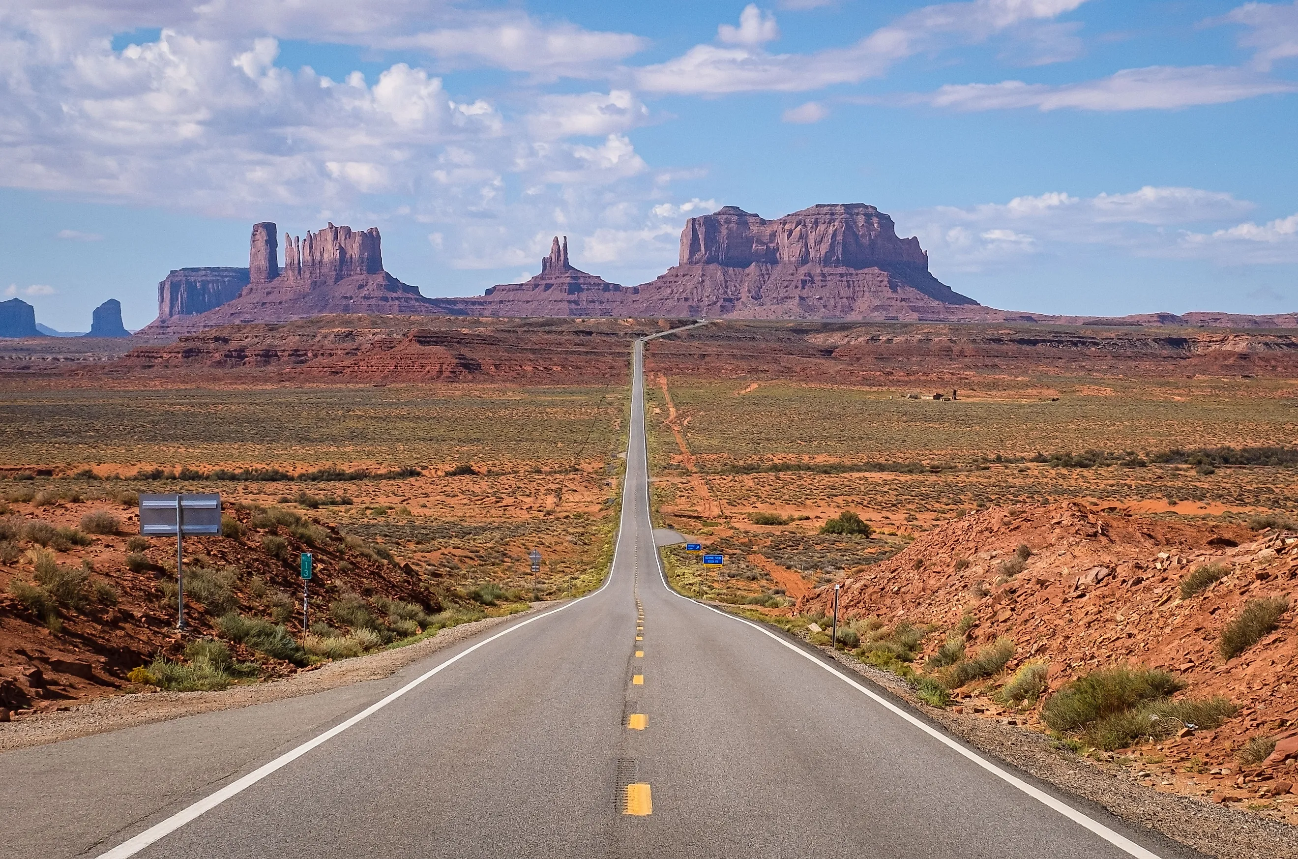
Monument Valley

Straddling the border between Arizona and Utah, Monument Valley is defined by enormous isolated sandstone buttes that rise sharply from a broad desert basin. The valley is managed by the Navajo Nation, and its towers (including the Mittens and Merrick Butte) reach over 1,000 feet above the valley floor. The landscape is the result of tens of millions of years of erosion stripping away softer rock layers while the more resistant De Chelly Sandstone held up to form the buttes.
Monument Valley has been filmed extensively since John Ford used it as the backdrop for Stagecoach in 1939, and visitors may recognize it from The Searchers, Forrest Gump, and countless other Western and road-trip films. A scenic pullout off Highway 163 is commonly called the Forrest Gump point. Vehicle access is limited to a few scenic driving loops and guided backcountry tours on unpaved roads that can become difficult after rain.
Grand Canyon

Grand Canyon National Park is one of the most extensively studied geological formations in North America and one of the most visited national parks in the United States. The canyon stretches for 277 miles with depths exceeding a mile in places. Its walls expose nearly two billion years of Earth's history, with the oldest rocks (the Vishnu Basement Rocks at the bottom) dating to around 1.84 billion years ago. The Colorado River continues to cut through ancient metamorphic and sedimentary stone today, actively shaping the canyon.
The South Rim is far more accessible than the North Rim, with the main viewpoints including Mather Point, Yavapai Point, and Desert View. Year-round amenities include the Yavapai Geology Museum and the historic El Tovar Hotel. The North Rim is roughly 1,000 feet higher in elevation, closes from mid-October to mid-May due to snow, and feels markedly different in climate and vegetation. Temperatures can swing 30-40 degrees between rim and river, creating distinct ecological zones from Ponderosa pine forest at the rim down to desert scrub at the bottom. Cooler, drier conditions give the clearest air for photography.
Petrified Forest

Petrified Forest National Park preserves one of the largest concentrations of fossilized wood on Earth. The stone-like logs scattered across the park are primarily ancient conifers that fell roughly 220 million years ago during the Late Triassic, when the area sat in a humid tropical lowland. Mineral-rich groundwater gradually replaced the organic material with quartz, creating a dense, multicoloured appearance from iron, manganese, and carbon impurities.
The park also covers the southern edge of the Painted Desert, where layered clay hills display bands of red, purple, and gray from varying iron and manganese content. Short trails including Blue Mesa and Crystal Forest, along with roadside stops on Petrified Forest Road, give close access to both the logs and the layered badland country. The park is high desert with limited shade and no gas stations inside the boundary, so water and sun protection are essential.
Arizona in Deep Time
These five landmarks span nearly two billion years of geological history, from the ancient basement rocks of the Grand Canyon to the Late Triassic fossil forests at Petrified Forest to the actively eroding buttes of Monument Valley. Each one is a window onto a different slice of Southwestern geology, and together they make the case that Arizona's landscape is better understood as a series of stories told in stone.