The Tallest Waterfall In A US National Park
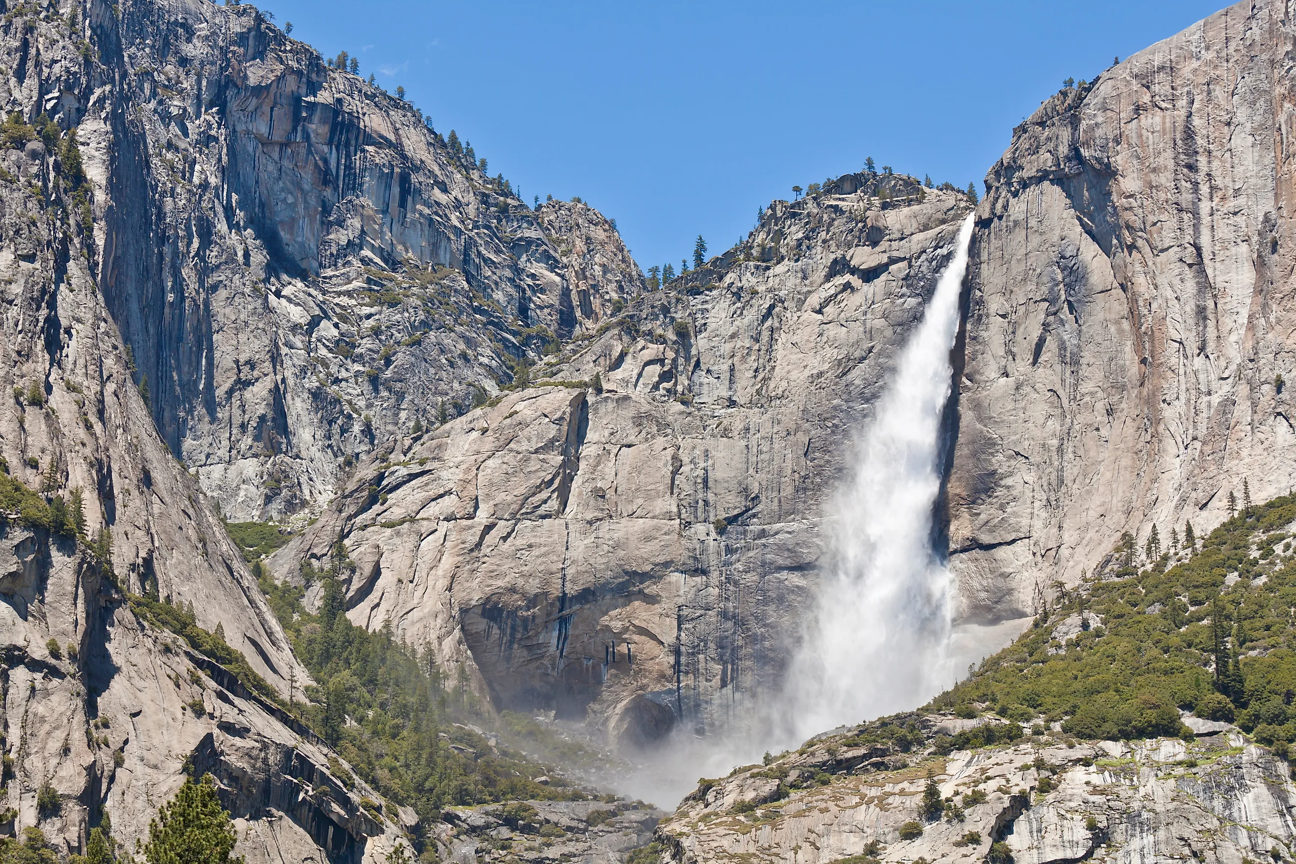
Yosemite National Park contains a waterfall that drops 2,425 feet from top to bottom, making it the tallest waterfall inside any of the 63 national parks in the United States. That number isn't a single vertical drop but a measured total across three connected sections of Yosemite Creek stacked on a cliff face as it spills off the north wall of Yosemite Valley.
While the massive granite wall framing the waterfall has remained virtually unchanged for millennia, the torrent rushing over it is an active, shifting force. Fueled directly by high-elevation snowmelt, Yosemite Falls transforms from a thunderous surge in spring to a silent, dry cliff face with only trickling water by late summer. That dynamic volume flows across three distinct tiers that collectively define the greatest total height in the national park system.
Yosemite Falls: The Total-Height Record

According to the National Park Service, Yosemite Falls consists of Upper Yosemite Fall at 1,430 feet, a middle section of cascades dropping 675 feet, and Lower Yosemite Fall at 320 feet, for a combined 2,425-foot descent. In addition to being the tallest waterfall in the US National Park system, it ranks among the tallest waterfalls in North America.
The water source is Yosemite Creek, which flows approximately November through July, with peak volume arriving in May as Sierra Nevada snowpack melts. By August, the creek's flow can drop to a trickle, and the falls sometimes run nearly dry until storms return in late autumn.
Why Yosemite Valley Has So Many Tall Waterfalls

Yosemite Falls is not an isolated feature. Yosemite Valley holds several of the tallest waterfalls in North America within a few miles of each other, including Bridalveil Fall and Sentinel Fall on the valley's south side, and the seasonal Ribbon Fall on the north side, near El Capitan. Ribbon Fall holds the record as the longest single-drop waterfall at 1,612 feet.
The U.S. Geological Survey traces the shared cause to uplift and glaciation that began reshaping the Sierra Nevada about two to three million years ago, with more than 40 cycles of glacial advance and retreat since 2.6 million years ago carving the region's canyons. Before glaciers arrived, the process began when tectonic uplift forced the ancient Merced River to cut a steep V-shaped canyon through the Sierra Nevada, far outpacing the erosion rates of its smaller feeding streams.
When glaciers later moved through the primary canyon, they widened and deepened it into the broad U-shaped trough seen today. The smaller tributary valleys were left "hanging" above the valley floor rather than being carved down to match it. Because several tributaries around the valley rim were left to drop their stream directly off the granite rim, the valley ended up ringed by some exceptionally tall waterfalls.
Trails to Yosemite Falls

The National Park Service maintains two primary routes for reaching Yosemite Falls, split between an easy valley-floor walk and a strenuous climb to the rim.
Lower Yosemite Fall Trail is a one-mile, paved loop with only 50 feet of elevation gain, that brings visitors to the base of the waterfall and includes interpretive exhibits on the area's natural and cultural history. The 0.6-mile eastern part of the loop is fully wheelchair accessible. The western half of the loop is mostly accessible excluding the last 180 feet with a 13.8 percent grade that may require additional assistance for some visitors to reach.
The Yosemite Falls Trail, by contrast, is one of the park's oldest routes, built between 1873 and 1877, and climbs 2,700 feet over a 7.2-mile round trip. Although, hikers can complete just the first 1.5 miles one way to reach a viewpoint of Upper Yosemite Fall. The National Park Service describes the first mile of that trail, up to a viewpoint called Columbia Rock, as a switchback climb through oak woodland gaining 1,000 feet, after which hikers can continue another half mile, partly downhill, to a viewpoint with close views of Upper Yosemite Fall.
Past that point, the NPS notes the upper half of the trail turns steep and rocky, following the route past Yosemite Creek itself near the lip of the falls, where the agency warns visitors to stay back from the water given the drop just beyond it. Hikers who reach the top can extend the route another 1.6 miles round trip to Yosemite Point or 5.8 miles round trip to Eagle Peak, both offering additional views of Half Dome and the surrounding granite terrain.
A separate route, Cook's Meadow Loop, covers one flat mile through the open meadow at the center of Yosemite Valley, beginning at the Valley Visitor Center or the Lower Yosemite Fall shuttle stop. The National Park Service lists it among the park's easy, wheelchair-accessible walks, with full views of Yosemite Falls, Half Dome, Glacier Point, and Sentinel Rock from multiple points around the loop, including Sentinel Bridge across the Merced River.
Scenery and Ecology Around the Falls

The lower mile of the Yosemite Falls Trail passes through oak woodland, according to the National Park Service, before opening onto exposed granite plateaus that frame views of Yosemite Valley, Half Dome, and Sentinel Rock from Columbia Rock. That transition from shaded woodland to open rock face reflects the broader habitat pattern the NPS describes across the park's western valley elevations, where chaparral and oak woodland give way to conifer forest as elevation increases.
The National Park Service identifies the American dipper as a common sight along Yosemite Creek and other park waterways, a bird that forages by walking directly along stream bottoms underwater. Steller's jay, acorn woodpecker, and common raven are among the species most regularly seen in the same oak and conifer habitat that borders the trail.
Higher on the cliffs surrounding the falls, the NPS and its climbing-closure notices document active peregrine falcon nesting sites on Yosemite Valley's granite walls, protected under seasonal climbing and access closures that typically run from March through mid-July. The exposed granite itself, the same rock that channels Yosemite Creek off the valley rim, supports little vegetation beyond lichen and scattered manzanita on ledges, a contrast to the oak canopy lower on the trail that provides most of the shade hikers get before the final, more exposed climb to the falls' overlook.
Visiting the Falls

Yosemite National Park's own visitation data shows how seasonal timing affects what a visitor actually sees. Through August 2025, the park recorded 2,919,722 recreation visits, a seven percent increase over the same period in 2024. The NPS states the park typically receives around four million visitors in a full year, with about three-quarters arriving between May and October.
That timing overlaps closely with when Yosemite Falls carries its heaviest flow, meaning a visitor in peak summer travel months will often catch the falls near their most dramatic, while a visit later in the season can coincide with the falls slowing to a trickle.
Yosemite's Record-Setting Falls
Yosemite Falls stands at the top of the national park record books with a total drop of 2,425 feet, built across three connected cascades plunging down the north wall of Yosemite Valley. Its immense height, and the surrounding concentration of towering cascades like Bridalveil and Ribbon Falls, is a direct legacy of the region's intense glacial history.
While the 2,425-foot height carved into the granite is permanent, the volume of the waterfall's presence is entirely dynamic. Driven strictly by Sierra Nevada snowmelt rather than a year-round river, Yosemite Falls transforms dramatically with the seasons. A spring visitor will witness a thunderous force shaking the valley floor, while an autumn traveler might see mostly dry granite cliffs where the torrent once roared. Ultimately, catching one of North America's tallest waterfalls in its full, record-setting glory is a matter of timing, a testament to a park defined as much by shifting seasons as by enduring stone.