Uluru/Ayers Rock
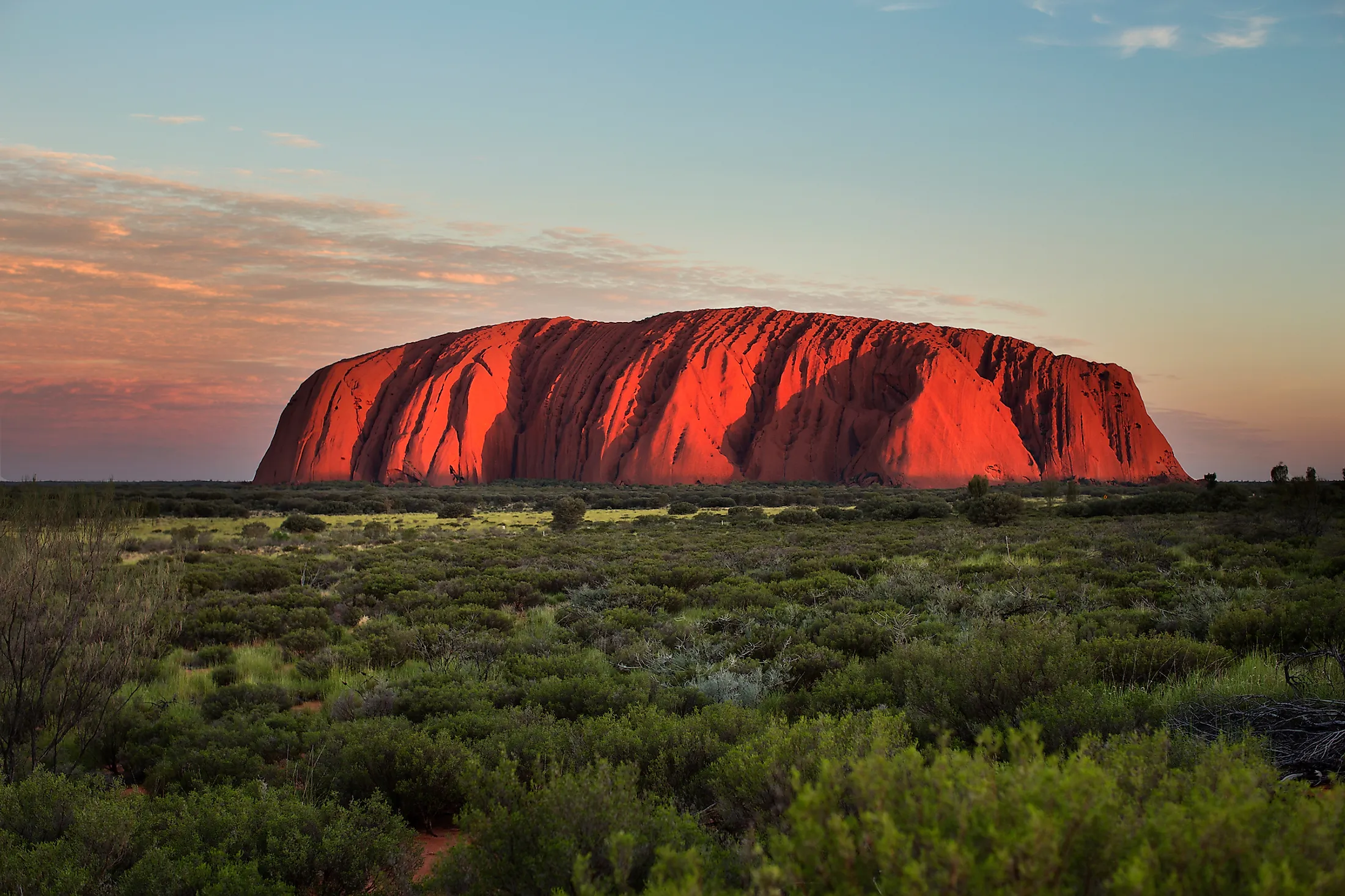
The Uluru Rock, also known as the Ayers Rock, is an isolated giant monolith and a famous natural landmark in Australia’s southwestern Northern Territory. This rock is located in an area with abundant waterholes, springs, ancient paintings, and rock caves and is a popular tourist destination, attracting over 400,000 visitors annually. The sandstone rock formation is considered a sacred place by several Aboriginal Australians, like the Anangu people. Uluru has a prominence of 348 meters and rises 863 meters above sea level, though most of it lies underground. Ayers Rock and the surrounding area were designated a World Heritage Site in 1987 for its natural significance. It received a second designation from UNESCO in 1994 for its cultural significance.
Location and Description

The Uluru/Ayers Rock is an iconic natural wonder within the 1,333 square kilometers Uluru–Kata Tjuta National Park located in Australia’s Northern Territory. The park is located approximately 440 kilometers southwest of Stuart (present-day Alice Spring) and 1,945 kilometers from Darwin. Apart from Uluru, the park also boasts of another prominent rock formation known Kata Tjuta or Olgas. The Uluru/Ayers Rock is located approximately 25 kilometers to the east of Kata Tjuta.
The Uluru Rock is an oval-shaped monolith measuring 3.6 kilometers long and 2.4 kilometers wide, with a perimeter of 9.4 kilometers. It is 348 meters taller than the surrounding area and rises 863 meters above sea level. The rock composed of sandstone contains a high feldspar proportion. Thus, the rock’s color changes with the change in the Sun’s position. At dawn or sunset, the Sun’s rays cause it to turn orange-red, making it more visually striking than any other time of the day. The rock top contains basins and gullies that produce water drops (cataracts) after rainstorms. Its base contains shallow sacred caves with paintings and carvings.
Naming

The Aboriginal Anangu group, particularly the Pitjantjatjara people, refers to the rock as “Uluru.” The name is a proper noun with no specific meaning in the local dialect. When William Gosse, an Australian explorer, sighted the rock in July 1873, he named it Ayers Rock after Sir Henry Ayers, South Australia’s Chief Secretary. The two names, Ayers and Uluru, have been used since then. In 1993, the rock was named Ayers Rock/Uluru in line with the dual naming policy, making it Northern Territory’s first feature to have two official names. It was renamed Uluru/Ayers Rock in November 2002.
Formation and Geology

The Uluru/Ayers Rock is an inselberg due to its isolation and prominence in a relatively flat plain. The monolith rock is homogenous and has no parting and jointing on the surface. It is composed of a type of sandstone known as arkose that contains abundant feldspar. The coarse-grained sandstone comprises an average of 50% feldspar, at most 25% conglomerate, and at least 25% quartz. The rock is gray when relatively fresh. However, the oxidation process causes the weathering out of the iron-bearing minerals, giving it a fierce red-brown color.

The Uluru/Ayers Rock is relatively younger and unrelated to the rock formation on the east of Mount Conner. However, it has the same age and origin as Kata Tjuta’s conglomerate. Uluru was a sand deposit and part of the alluvial fan that stretched southwards and westwards from Petermann, Mann, and Musgrave Ranges and separated from the nearby alluvial fan that formed the Kata Tjuta. Several local legends also explain the rock’s existence. According to one legend, the landscape as it is today did not exist until creator beings formed it through a destruction and creation process. Another local myth suggests Uluru was built by two boys who were playing with mud. After their game, the boys abandoned the mud and climbed Mount Conner, where they died, and their bodies turned into boulders. Yet another legend suggests that Uluru was formed when the Earth rose up to mourn the death of two tribal leaders killed in a great battle.
Brief History

Although the area around the rock was inhabited over 10,000 years ago, Europeans first visited the region in the 1870s and mapped the two giant rocks in 1872. William Gosse and Ernest Giles were the first Europeans to explore the area, with Giles sighting Kata Tjuta and Gosse observing Uluru. Parts of Northern Territory, South, and Western Australia were designated Aboriginal reserves between 1918 and 1920, and the Aboriginal people were forced to live in government-owned settlements. Tourism in the area began in 1936. By 1940, several European settlements had been established in the area to promote tourism. The area was designated as the Uluru-Kata Tjuta National Park in 1958.