10 Most Beautiful Lakes In Tennessee
Located in the Southeastern United States, the landlocked state of Tennessee is full of unique natural splendors. Placed at the meeting point of three significant geographic regions, the Appalachian Mountains, the Cumberland Plateau, and the Gulf Coastal Plains, Tennessee is home to several long rivers and lakes. Although most of these beautiful lakes in the Volunteer State are artificial and located in remote locations, they offer ample recreational opportunities attracting residents and tourists alike. Moreover, the visitors can relax peacefully along the shores of the lakes to escape from the stresses of daily life and reconnect with nature.
Reelfoot Lake

Covering an area of 15,000 acres, Reelfoot Lake is Tennessee’s only large shallow natural lake, located on the boundary between Lake and Obion counties in the state’s upper northwestern corner. Geological studies have revealed that Reelfoot Lake formed during the 1811 to 1812 New Madrid Earthquakes, which led to the subsidence of the land on the eastern side of the Mississippi River and the formation of a depression that was later filled with water. As per a local legend, the lake takes its name after a 19th-century Chickasaw Indian chief who had a deformed foot.
Reaching an average depth of 5.5 feet, and a maximum depth of 18 feet, Reelfoot Lake boasts bald cypress trees, surrounding swamplands, bayou-like ditches that link more open water basins, and nesting pairs of bald eagles. At the beginning of the 20th century, the state of Tennessee acquired the grounds surrounding the lake and established the Reelfoot Lake State Park. Some recreational activities offered at the State Park include fishing, hiking, boating, picnicking, wildlife viewing, and visiting the RC Donaldson Memorial Museum and nature center. The National Park Service declared Reelfoot Lake a National Natural Landmark in 1966.
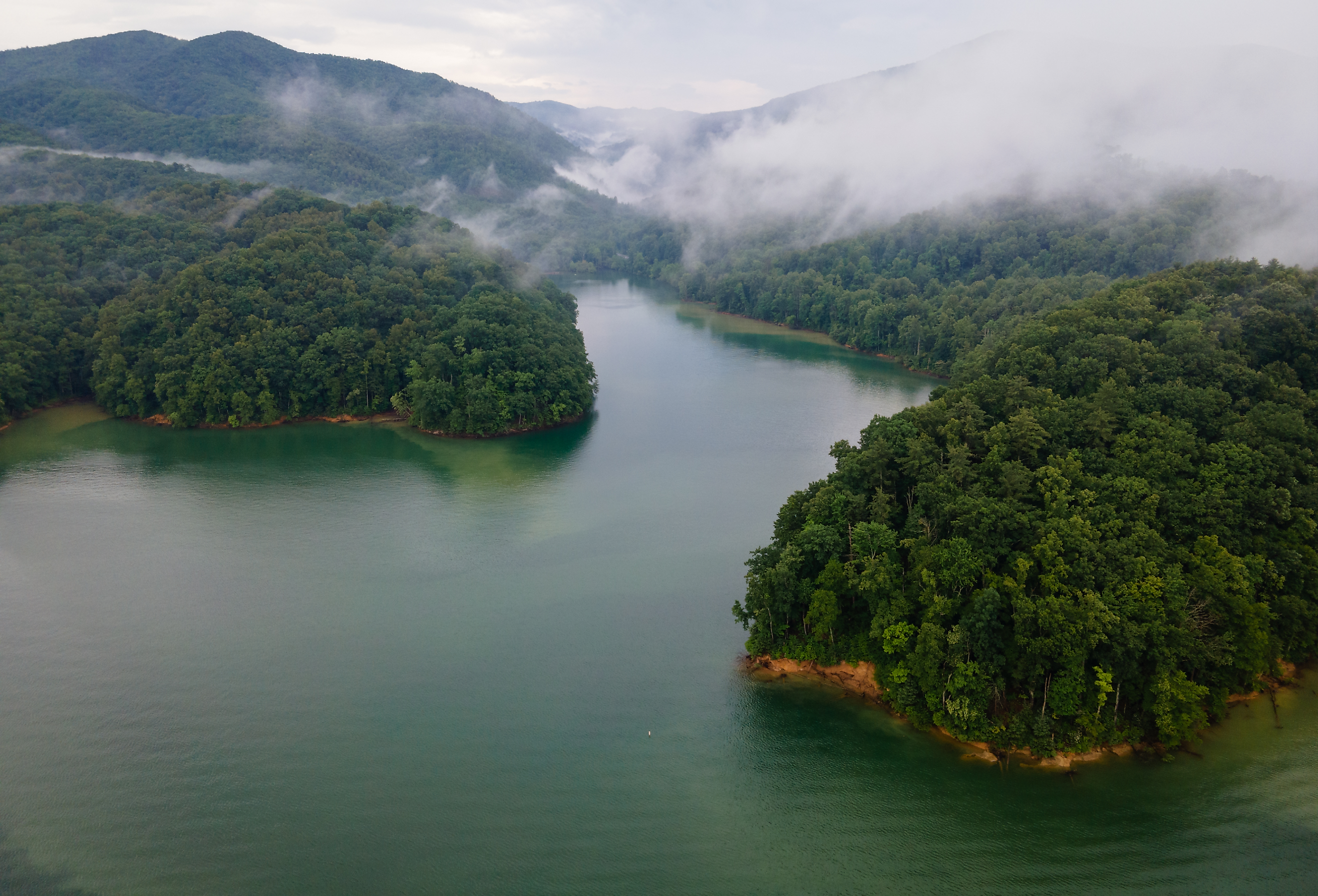
Norris Lake

Located in East Tennessee’s Great Appalachian Valley, Norris Lake is a reservoir created by the construction of Norris Dam on the Clinch River’s Cove Creek Site. The reservoir, dam, and adjacent town have been named in honor of the well-known American politician and US Senator George William Norris, who authored the legislation which created the Tennessee Valley Authority. Covering a surface area of 52.9 square miles, Norris Lake boasts more than 800 miles of shoreline and a flood-storage capacity of about 1,113,000 acre-feet. The lake has a maximum length of 206 miles, a maximum width of 1.2 miles, an average depth of 75 feet, and a maximum depth of 210 feet. From Norris Dam, the lake extends for about 75 miles up the Clinch River and 56 miles up the Powell River.
Norris Lake houses over 56 species of fish, including black bass, sunfish, striped bass, walleye, and crappie. The crystal-clear waters of Norris Lake make it a popular destination for various water-based recreational activities like fishing, swimming, boating, kayaking, waterskiing, and paddle boarding. In addition, along the lake’s shoreline, you can enjoy different activities like hiking, golfing, horseback riding, camping, and rock climbing.
Cherokee Lake

This artificial reservoir was created by the Holston River’s impoundment by the Cherokee Dam. Covering a surface area of 28,780 acres with a 400-mile-long shoreline, the lake reaches an average depth of 30 ft and holds a water volume of 749,406 acre-ft. Both the dam and the reservoir are named after the indigenous Cherokee tribe who initially inhabited the area. Home to various fish species like crappie, sauger, sunfish, and black bass, the lake has a comparatively higher fish density than most reservoirs maintained by the Tennessee Valley Authority. At present, Cherokee Lake has developed into a popular tourist destination, offering a variety of recreational activities like swimming, canoeing, boating, kayaking, paddle boarding, fishing, and camping. The Panther Creek State Park, various lakefront resorts, a state wildlife management area, public boating access areas, and RV and tent campgrounds occupy the shores of the lake. Cherokee Lake Reservoir also served as the Bassmaster Eastern Open tournament venue in October 2020.
Douglas Lake

Also known as the Douglas Reservoir, Douglas Lake was created by the construction of Douglas Dam on the French Broad River in the state’s eastern portion. The lake is only a few miles from the Great Smoky Mountains National Park, as well as from the Gatlinburg and Pigeon Forge areas. Covering a surface area of 44.41 square miles and placed at an elevation of 876 feet, Douglas Lake has a maximum length of 60 miles, a maximum width of 3,527 feet, a maximum depth of 140 feet, a water volume of 1,081,880 acre-feet, and a 513-mile-long shoreline. The major towns located around the lake include Dandridge, Baneberry, Sevierville, White Pine, and Newport. Surrounded by rolling hills, farmland, and residential areas, Douglas Lake offers various recreational activities like fishing, swimming, boating, camping, and bird-watching, attracting over 1.7 million visitors annually.
Dale Hollow Lake

Formed by the construction of the Dale Hollow Dam on the Obey River, the Dale Hollow Reservoir is one of Cumberland’s four major flood control reservoirs. Although the reservoir is primarily located in northern Tennessee, occupying parts of Overton, Clay, and Pickett counties; small parts of the lake also stretch into the Clinton and Cumberland counties of Kentucky. The Dale Hollow Lake and the surrounding Cumberland and Obey rivers are home to several fish species like trout, catfish, muskellunge, largemouth bass, walleye, crappie, smallmouth bass, and gar. The lake offers a variety of water-based recreational activities like fishing, water skiing, tubing, and waterboarding. A small island named Geiger Island, located on Dale Hollow Lake is a primitive camping site and is significantly used during the summer months.
Percy Priest Lake

Created by the construction of J. Percy Priest Dam on the Stones River, this 14,200-acre reservoir occupies portions of Wilson, Davidson, and Rutherford counties in the state’s north-central portion. The impounding dam and the lake have been named in honor of the American politician James Percy Priest. Reaching a summer pool elevation of 490 feet, the lake has a maximum length of 42 miles. Surrounding the lake are 18,854 acres of public land, of which 10,000 acres have been devoted to the management of wildlife. There are three campgrounds, eleven picnic areas, and twelve boat launching ramps that the Natural Resource Management Office maintains, making the area ideal for public recreation.
Old Hickory Lake

Located in the Sumner and Davidson counties in the state’s north-central portion, this 22,500-acre reservoir was created by the construction of the Old Hickory Lock and Dam on the Cumberland River. Placed about 25 miles upstream from the state capital Nashville, the reservoir’s northern shoreline is home to the city of Hendersonville, while its southern part, immediately upstream of the lock and dam, is the Old Hickory neighborhood. Named in honor of US President Andrew Jackson, who was nicknamed "Old Hickory," the lake extends for over 97.3 miles with a minimum pool elevation of 442 feet. The various public facilities along the lake include the Old Hickory Lake Arboretum, two campgrounds managed by the US Army Corps of Engineers, eight marinas, and 41 boat access sites.
Watauga Lake

Also referred to as Watauga Reservoir, Watauga Lake was created by the construction of the TVA Watauga Dam on the Watauga River. The 6,430-acre Watauga Lake occupies portions of Carter and Johnson Counties, and some of the nearby cities and communities that surround the lake include Johnson City, Roan Mountain, Hampton, Mountain City, and Elizabethton. With a 104.9-mile-long wooded shoreline and a flood-storage capacity of 152,800 acre-feet, the lake has a maximum length of 16.3 miles, an average depth of 16.0 miles, and reaches a maximum depth of 265 feet. Watauga Lake’s elevation is the highest among all TVA lakes, placed at 1,959 feet above sea level at "full pool."
A significant portion of the lake’s shoreline is within the Cherokee National Forest in the state’s northeastern corner, close to its boundary with North Carolina. Fishing, boating, camping, and water skiing are some of the popular recreational activities offered here. Moreover, the release of additional impounded water from both the Watauga and Wilbur dams provides opportunities for several downstream water-based recreations like trout fishing, kayaking, and whitewater rafting on the Watauga River.
Chickamauga Lake

Chickamauga Lake is a reservoir created in 1940 by the construction of the Chickamauga Dam on the Tennessee River, immediately north of the city of Chattanooga. Covering a surface area of 36,240 acres, the lake is just upstream of Nickajack Lake and downstream from Watts Bar Lake. Extending from the Watts Bar Dam to Chickamauga Dam, the lake has a maximum length of 58.9 miles with 810 miles long shoreline and a flood-storage capacity of 345,300 acre-feet. Named after the indigenous Chickamauga Cherokee group that inhabited the area, surrounding Chickamauga Lake are Hamilton, Meigs, and Rhea counties in the state’s southeastern portion. Two bridges cross the lake at State Route 30 and State Route 60. The lake receives its significant inflow from the Hiwassee River, which drains into the lake at Hiwassee Island. Various gamefish species, like catfish, walleye, largemouth bass, redear sunfish, striped bass, bluegill, and smallmouth bass, live in the lake, making it a popular destination for fishing. Moreover, due to the surrounding area's high population density, the lake's southern end is popular for various outdoor recreational activities.
Radnor Lake

Radnor Lake is a beautiful lake located within the 1,368-acre Radnor Lake State Natural Area just outside the state capital Nashville. The lake, created in 1914 by the Louisville and Nashville Railroad Company, was initially utilized as a watering hole for steam locomotives. On the Tennessee Ornithological Society’s request, Radnor Lake was declared a "Wildlife Sanctuary" in 1923. Several avian species, like ring-necked ducks, gadwall, American wigeon, and canvasback find refuge in the Radnor Lake State Park. Several miles of hiking trails run through the hills surrounding the lake and offer spectacular views of it. Radnor Lake State Natural Area is a day-use area where visitors can enjoy the lake and park throughout the day, and hence there is no camping and picnicking allowed here.
There are many picturesque water bodies in Tennessee, the nation’s 36th largest and 15th most populous state. With rugged wooded shorelines, scenic hiking trails, spectacular views, and ample recreational opportunities, each of these lakes and their surrounding areas offer something for everyone and serve as an ideal vacation destination. So, what are you waiting for? Start planning your trip to these magnificent lakes and enjoy quality time with your loved ones.