Canada, Denmark, and the Arctic’s Strangest Territorial Dispute The Whisky War
Two NATO founding members spent nearly half a century in a territorial dispute over a 1.3-square-kilometer barren rock in the High Arctic. They marked each new claim by planting their respective flag on the island and leaving a bottle of liquor for the next visitor (Canadian whisky on the Canadian side, Danish schnapps on the Danish), giving the dispute its informal name: the Whisky War. Hans Island, located in the middle of the Nares Strait between Canada's Ellesmere Island and northwestern Greenland, lay within the 12-nautical-mile territorial waters of both countries, creating an overlap that international maritime law could not cleanly resolve. The dispute lasted from 1973 until June 14, 2022, when the foreign ministers of Canada and Denmark and the prime minister of Greenland signed an agreement formally dividing the island, and it ended legally on December 19, 2023, when the Danish parliament ratified the agreement. The new border on Hans Island, just under 1.3 kilometers long, gave Greenland its first land border in history.
The Geography and Early History

Hans Island sits at 80°49' north latitude, almost exactly halfway across the 35-kilometer-wide Kennedy Channel of the Nares Strait, the body of water that separates Ellesmere Island in Canada's Nunavut territory from the northwest coast of Greenland. The island has an area of about 1.3 square kilometers, a length of 1,290 meters, and a maximum elevation of about 168 meters. Its Greenlandic name, Tartupaluk, means "kidney-shaped" in Inuktitut and Greenlandic, and the island has likely been part of Inuit hunting grounds since at least the 14th century, used as a vantage point for spotting polar bears, walruses, and other marine mammals on the surrounding sea ice. The first European to map the area was the American Arctic explorer Charles Francis Hall, whose 1871 expedition named the island after his Greenlandic Inuit interpreter Hans Hendrik (also called Suersaq), who guided several major Arctic expeditions in the 1850s and 1860s.
Greenland had been administered by the Danish-Norwegian crown since medieval Norse colonization, and Greenland remained with Denmark when Norway separated from the Danish realm under the 1814 Treaty of Kiel. After Britain transferred its Arctic territories to the newly created Dominion of Canada in 1880, both Denmark (through Greenland) and Canada had plausible claims to Hans Island, but the imprecise Arctic mapping techniques of the late 19th and early 20th centuries left the exact boundary undefined. Danish expeditions accurately mapped the tiny island in the 1920s, by which point both countries effectively considered it part of their own territory. The core legal problem was that the Nares Strait at this point is only 35 kilometers wide, which means the 12-nautical-mile (about 22-kilometer) territorial waters extending from both Ellesmere Island and Greenland overlap, and Hans Island sits inside both zones.
The "Whisky War"

The Whisky War proper began in 1973, when Canada and Denmark finalized a maritime boundary through the Nares Strait that explicitly left Hans Island's status unresolved. Both countries continued to claim the island, but the dispute remained mostly dormant until 1984, when Danish Minister for Greenland Affairs Tom Høyem flew to the island, planted a Danish flag, and left a bottle of schnapps with a note reading "Velkommen til den danske ø" ("Welcome to the Danish Island"). Canadian forces visited subsequently with a Canadian flag and a bottle of Canadian whisky, beginning a back-and-forth tradition in which each visiting party would replace the previous country's flag and bottle with their own; the alcoholic exchanges gave the dispute its informal name.
The most prominent confrontation came in July 2005, when Canadian Defence Minister Bill Graham landed on the island unannounced, accompanied by Canadian forces who erected an inukshuk (a traditional Inuit stone marker) and a fresh Canadian flag. Denmark filed a formal diplomatic complaint to Ottawa, with the Danish foreign ministry stating that Hans Island was Danish territory and that Graham's visit was unauthorized. Despite the ceremonial nature of the flag-and-bottle exchanges, both countries maintained legal claims on the island and the surrounding waters throughout the dispute, and both occasionally sent naval patrols (Danish frigates and Canadian icebreakers) through the area. After the 2005 incident, the two governments quietly agreed to begin a formal resolution process.
The 2022 Agreement and Its 2023 Ratification

The formal resolution process moved slowly for over a decade. A joint Canada-Denmark technical task force was established in 2018, the two countries reached a tentative agreement at the official level in November 2021, and a public signing ceremony followed on June 14, 2022. Canadian Foreign Minister Mélanie Joly, Danish Foreign Minister Jeppe Kofod, and Greenland Prime Minister Múte Bourup Egede signed the agreement in Ottawa, marking the occasion with one final symbolic exchange of liquor: bottles of Canadian maple whisky and Danish bitters.
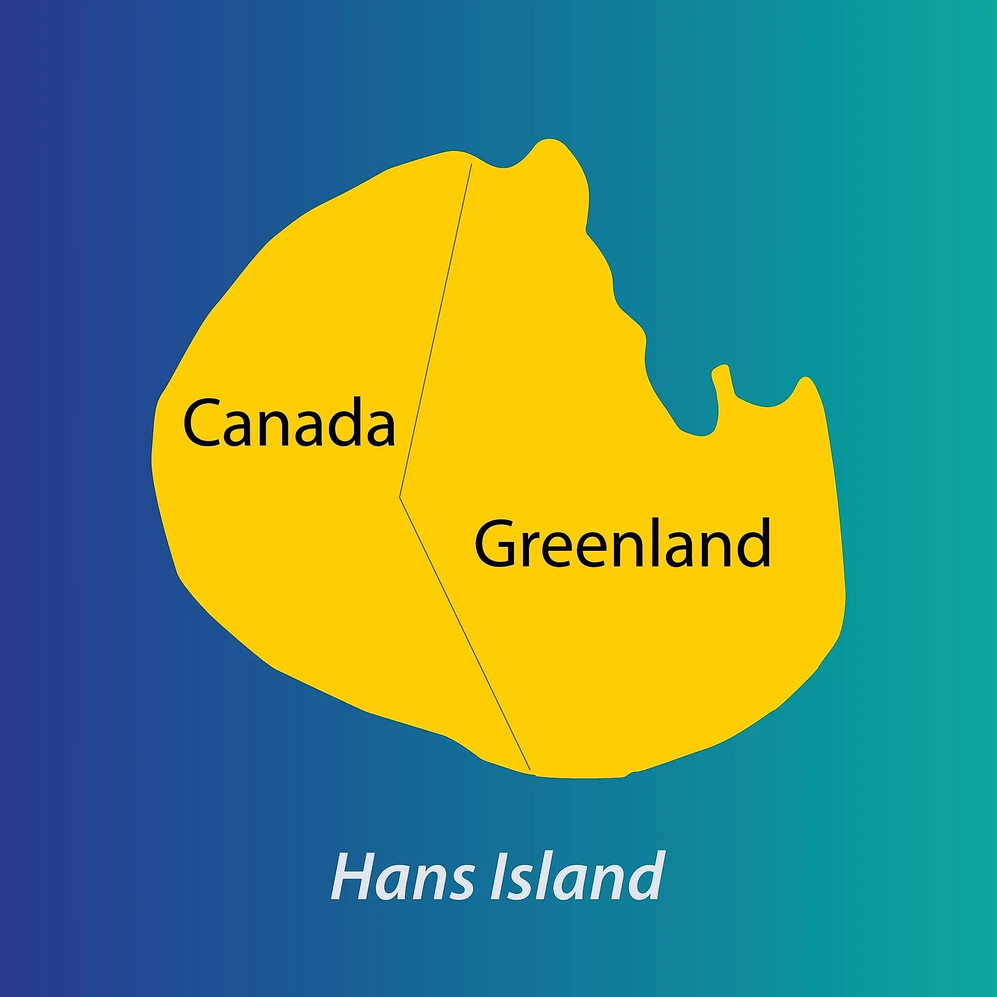
The agreement created a land border running roughly north to south across the island along a natural ravine, dividing it into two unequal portions: Greenland (and therefore the Kingdom of Denmark) received the larger northern share of about 60 percent, and Canada received the southern portion of about 40 percent. The new land border traversing the island is about 1,280 meters long. The agreement also delimited the remaining maritime border in the Lincoln Sea (north of Greenland) and the Labrador Sea (south of Greenland), creating what Canada and Denmark describe as the world's longest international maritime boundary at approximately 3,962 kilometers. The Danish Folketing (parliament) formally ratified the agreement on December 19, 2023, completing the legal resolution from Denmark's side and making the new border on Tartupaluk official.
Implications for the Inuit

Hans Island has been part of Inuit hunting territories since at least the 14th century, used by Inughuit (Polar Inuit) groups from northwestern Greenland and by Inuit hunters from Ellesmere Island as a vantage point for spotting marine mammals on the surrounding sea ice and as a stopover during long-distance polar bear hunts. The closest permanently inhabited Inuit settlement on the Greenland side is Siorapaluk in the Avannaata municipality, about 349 kilometers south of Hans Island. On the Canadian side, the nearest permanent settlement is Grise Fiord on Ellesmere Island, about 603 kilometers to the southwest.

Inuit organizations on both sides of the new border participated in the consultations leading to the 2022 agreement. Nunavut Tunngavik Incorporated (the Inuit organization that administers the Nunavut Land Claims Agreement on the Canadian side) and Greenlandic Inuit community organizations were consulted during the negotiating process, and the final agreement guarantees continued traditional access to the island for hunting and other customary uses by Inuit from both jurisdictions. The Premier of Nunavut and Inuit leaders publicly described the consultation as significant but partial: the guarantee covers the land of Hans Island itself but does not extend to the surrounding sea ice or to the broader Inuit Nunaat region, where cross-border traditional use is far more extensive than on Hans Island alone. Inuit leaders on both sides have suggested the agreement is a first step rather than a comprehensive recognition of cross-border Inuit territorial rights.
Why the Hans Island Settlement Still Matters
The June 2022 agreement and its December 2023 ratification ended what was both one of the world's longest-running and lowest-stakes territorial disputes between major powers. The new border on Hans Island was Greenland's first land border anywhere in the world: before 2022, the world's largest island had no land neighbor at all. The Canada-Denmark maritime boundary that the agreement finalized, at about 3,962 kilometers, is now described by both governments as the world's longest international maritime border. Canada and Denmark publicly framed the settlement as a demonstration that territorial disputes can be resolved through diplomacy rather than force, a message deliberately timed to contrast with Russia's invasion of Ukraine four months before the signing. The agreement also stands as a precedent for the peaceful negotiation of Arctic sovereignty questions, an issue that has acquired renewed prominence as climate change opens new shipping routes through the Arctic and great-power competition over the region intensifies into the mid-2020s.