Which State Has The Most Counties?
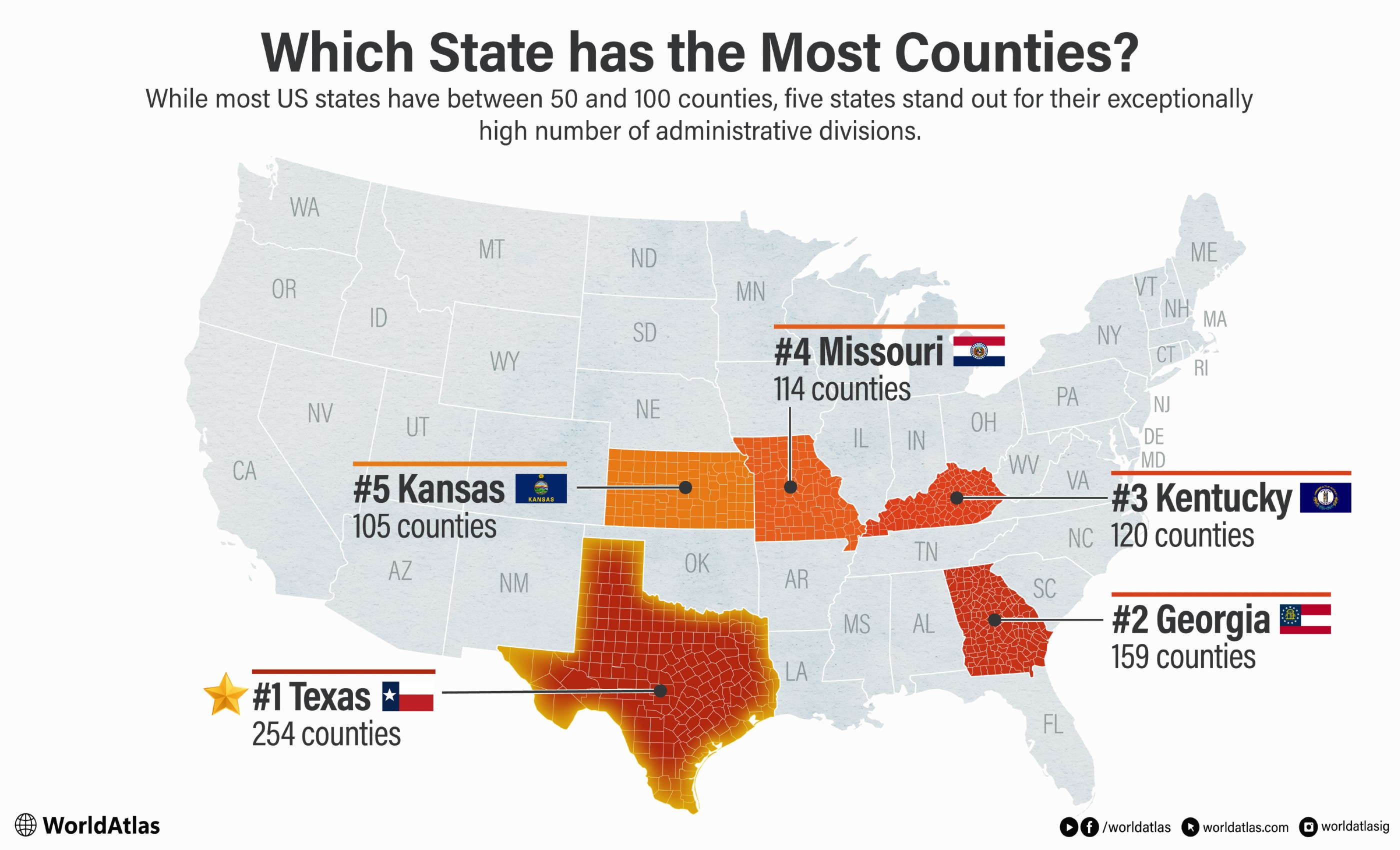
Texas has the most counties of any US state, with 254 counties. It has nearly 100 more counties than the state that ranks second: Georgia, with 159 counties. Texas's 254 counties reflect inherited municipalities, rapid Anglo-American settlement and westward expansion, the state's vast size and division of western lands, and efforts to keep local government accessible. Examine the history of Texas's counties, the reasons for its large number of counties, and the newest county in Texas.
History

Spanish explorers began mapping Texas between 1519 and 1540. However, settlements were not established until the 1690s and early 1700s in the form of missions. San Antonio was founded in 1718. Ysleta, established in 1680 and now within El Paso, is often described as Texas's oldest town. By 1800, there were three main Spanish settlements, including Goliad and Nacogdoches.
The Louisiana Purchase in 1803 gave the US access to a great deal of land out west, but it didn't settle the question of who owned Texas: the US or Spain. After the Mexican War of Independence ended in 1821, Spanish rule ended, and Texas became part of independent Mexico. Settlers from the United States subsequently arrived in large numbers, and estimates place the population at about 20,000 settlers and 4,000 enslaved people by 1835. This was in part due to efforts from the Mexican government, which encouraged settlers from the US to come in.

The Texas Revolution grew from disputes over immigration and customs enforcement, resistance to Santa Anna's shift from federalism toward centralism, and underlying conflict over slavery. Fighting began in 1835 and ended in a Texan victory in 1836. Although Texas sought annexation, the United States delayed action because admitting another slave state was politically contentious and annexation risked war with Mexico, which still claimed Texas. In that nine-year period, Texas was known as the Lone Star Republic.
By 1836, after periods of Spanish and Mexican rule, Texas was organized into 23 municipios, or municipalities. These were concentrated in its more populated eastern and southern regions. The units were run by ayuntamientos, which acted as a town council and managed policing, healthcare, food inspection, road repair, and taxation.
Following the Texas Revolution, these municipios were converted into counties, and settlers continued adding new counties as they traveled west. When Texas became a state in 1845, it had 36 regular counties. Another 31 were created in 1846 and 1847, bringing the total to 67. This expansion would continue throughout the decades, with 13 added in 1848 and 1849, 71 added in the 1850s, and 19 more between 1860 and 1875. The largest single expansion came in 1876, when the legislature created 54 counties across the Panhandle and South Plains, many with regular square or rectangular boundaries. The last 30 counties in Texas were created between 1883 and 1921, leading to its current total of 254 counties.
Why Are There So Many Counties in Texas?

Texas has so many counties primarily because of its enormous size and the 19th-century goal of keeping local government accessible. The state covers about 261,232 square miles of land and 268,596 square miles in total. It spans approximately 801 miles north to south and 773 miles east to west. Only Alaska is larger, but Alaska uses boroughs and census areas rather than counties.
As settlers moved west, Texas lawmakers divided the territory into manageable counties so residents would not have to travel excessive distances to reach a courthouse. This principle is often summarized as keeping the county seat within a day’s ride, although the constitution never established a formal day’s ride limit.

The Texas Constitution of 1876 helped shape the resulting county map. Its original text required counties formed from unorganized territory to cover at least 900 square miles and to be square where possible. These requirements helped produce the Panhandle’s regular grid of square and rectangular counties.
Article IX has since been amended. Under the current constitution, a county carved from existing counties must contain at least 700 square miles. Creating one with fewer than 900 square miles requires a two-thirds vote in each legislative chamber, and a new county cannot extend within 12 miles of the existing county seat from which its territory is taken.
The constitution also encourages centrally located county seats. Under Article IX, Section 2, moving a seat located within five miles of a county’s geographical center requires approval from two-thirds of the voters casting ballots on the question.
Together, Texas’s vast area, westward settlement, deliberate division of western lands, and emphasis on accessible county seats explain why the state developed 254 counties, the most in the United States.
The Newest County in Texas

Kenedy County, in South Texas on the Gulf Coast, was the last Texas county created. It was founded in 1921 and is the third least populous county in Texas, with only 319 residents according to the most recent data from the US Census Bureau. This represents an 8.9% decrease from its population of 350 people in 2020. Loving County was the last to be organized, or in its case reorganized, in 1931.
US 77 runs north-south through Kenedy County as part of the planned I-69E corridor. Only a short segment near the Willacy County line currently carries the I-69E designation. The county was originally part of Cameron, Hidalgo, and Willacy Counties. It was named after a rancher named Mifflin Kenedy, who ran or was a partner in several ranches. One was the King Ranch, which at around 825,000 acres is the largest ranch in the United States by total acreage. It covers a significant portion of Kenedy County. Another historic ranch in the county is Kenedy Ranch, established by Mifflin in 1882. Today, approximately 235,000 acres of the ranch are owned and maintained by The John G. and Marie Stella Kenedy Memorial Foundation.

There are no incorporated communities or towns in Kenedy County, but the county does contain part of Padre Island National Seashore. Padre Island National Seashore protects 70 miles of coastline on the barrier island and contains one of the country's last intact coastal prairie habitats. Travelers come here to go fishing, swim on the beach, or search for seashells. Wildlife viewing is another popular activity, especially when park authorities release sea turtle hatchlings for them to traverse across the beach and into the water. Public hatchling releases typically occur between mid-June and August, although dates are unpredictable and releases may be canceled.
US States With The Most Counties
| Rank | State | Number of counties |
|---|---|---|
| 1 | Texas | 254 |
| 2 | Georgia | 159 |
| 3 | Kentucky | 120 |
| 4 | Missouri | 114 |
| 5 | Kansas | 105 |
(Source: U.S. Census Bureau and official state government sources.)
Just a Day's Ride Away
Today, Texans don't need to ride horses to get to their destination, although the tradition of cowboys and ranch life plays a big role in both their economy and culture. Texas's county network reflects historical efforts to make local government more accessible across a vast state. Texas went from 23 municipalities in 1836 to 254 county units by 1921, although Loving County was not reorganized until 1931, giving Texas the largest number of counties of any US state.