The Highest County In The United States
Most high-elevation records come down to one exceptional mountain. The title for America's highest county does not. San Juan County, Colorado, has an average elevation of about 11,240 feet, higher than any other U.S. county once the whole terrain is averaged. No lone summit accounts for it. Most of this compact county in southwestern Colorado rests on extremely high ground. Even Silverton, the low point of daily life here, lies more than 1,900 feet below the county mean. Old mining roads run past settlements above 11,000 feet, volcanic ridges rise along the Animas River, and public land makes up most of the map. Numbers that read like mountaintop elevations describe ordinary ground.
The Average Elevation Is 11,240 Feet

San Juan County has the national record for mean county elevation at about 11,240 feet above sea level. The Town of Silverton reports that no U.S. county sits higher on average, while the County Highpointers Association ranks Hinsdale County second at 10,826 feet and Lake County third at 10,790 feet. The same terrain analysis puts about 87% of San Juan County above 10,000 feet, with the elevation distribution peaking near 12,100 feet. The distinction matters because a county can contain a very tall mountain without being uniformly high. Lake County, for example, includes 14,440-foot Mount Elbert, yet the lower ground of its Arkansas River valley leaves the overall mean below San Juan's. High elevation here is not confined to a few summits. It runs across most of the county.
Silverton Sits Nearly 2,000 Feet Below The County Average

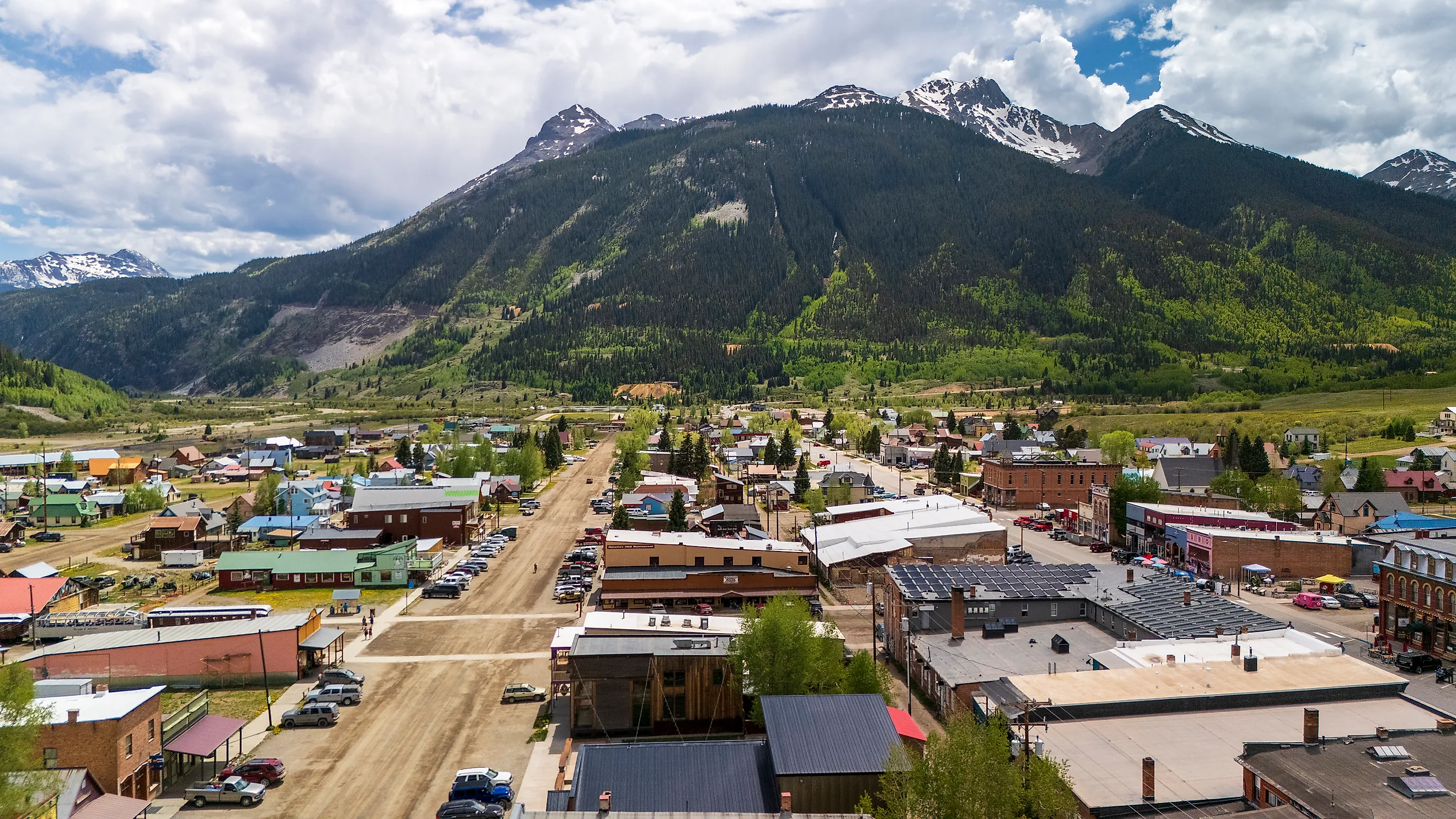
Silverton, the county seat and only incorporated town, stands at 9,318 feet. That is nearly 2,000 feet below San Juan County's mean elevation. The town lies in Bakers Park, a relatively open stretch of the Animas Valley, which is why its streets can feel surprisingly level despite the walls of mountains on every side.
A U.S. Geological Survey study of the South Silverton mining area recorded elevations from 9,125 feet along the Animas River to 13,451 feet on Kendall Peak. Nearly a dozen peaks and sharp ridges within that 18.5-square-mile study area rise above 13,000 feet. For visitors, the numbers become immediate vertical relief: high basins, glacial cirques, and steep ridges begin almost as soon as the roads leave town.
Only 705 People Lived Here At The 2020 Census

San Juan County counted only 705 residents at the 2020 census, according to the U.S. Census Bureau. Across 387.52 square miles of land, that works out to a population density of just 1.8 people per square mile.
Almost everyone lives in or near Silverton. Beyond town, the settlement thins quickly as the roads run into forest, former mining districts, and alpine terrain.
The Town of Silverton reports that about 89% of San Juan County is public land managed by the U.S. Forest Service and Bureau of Land Management. The upshot for visitors is an unusually direct path into the mountains: trailheads, four-wheel-drive roads, and backcountry terrain start close to the historic center rather than beyond a wide belt of development.
The County Was Built On Ancient Volcanoes

The San Juan Mountains are the largest surviving erosional remnant of a volcanic field that once covered much of the southern Rocky Mountains, according to the U.S. Geological Survey. Early volcanoes erupted huge volumes of lava and breccia roughly 35 to 30 million years ago, and explosive activity followed. In the central San Juans, at least 8,800 cubic kilometers of dacitic and rhyolitic magma erupted in nine major ash-flow sheets between about 28.3 and 26.5 million years ago, accompanied by repeated caldera collapse. Around Silverton, the San Juan and Uncompahgre calderas each spanned about 20 kilometers. Later hydrothermal activity drove mineral-rich fluids through fractures in the volcanic rock, concentrating the gold, silver, lead, copper, and zinc ores that later drew miners into these mountains.
Mining Produced More Than $65 Million In Precious Metals

Silverton became the center of a major mining district after prospectors moved into the San Juans in the 1870s. A National Park Service landmark nomination records more than $65 million in precious-metal production from the district between 1882 and 1918. Miners extracted silver, gold, lead, and copper, and the rush left behind mills, rail connections, houses, businesses, and satellite settlements in terrain that was difficult to reach even in summer.
Much of that history is still visible rather than shut away in archives. Downtown Silverton belongs to a National Historic Landmark district, and the Durango and Silverton Narrow Gauge Railroad still reaches town on its historic mountain route. The Town of Silverton says the railway brings roughly 150,000 passengers to Silverton each year, a use of infrastructure built for the mining era that has become one of the county's major visitor draws.
The Alpine Loop Climbs To About 12,800 Feet

The Alpine Loop Back Country Byway is one of the clearest demonstrations of San Juan County's altitude. The Bureau of Land Management describes the 63-mile route as a high-clearance, four-wheel-drive road system that connects Silverton, Ouray, and Lake City and climbs through alpine terrain to about 12,800 feet.
Animas Forks, reached from the Silverton side of the loop, stands at 11,200 feet. The BLM records that its first log cabin went up in 1873 and that by 1876 the mining settlement had 30 cabins, a hotel, a general store, a saloon, and a post office.
That elevation is only about 40 feet below San Juan County's mean. Standing among the surviving buildings therefore places a visitor almost exactly at the altitude of an average point in America's highest county, with bare ridges and high basins rising above the old townsite.
The Three Counties Closest To San Juan County
The next three places in the national mean-elevation ranking are also in Colorado. Hinsdale County averages 10,826 feet, Lake County averages 10,790 feet, and Mineral County averages 10,411 feet. All three hold extensive terrain above 10,000 feet, but their lower valleys and drainage areas leave the county-wide averages below San Juan County's 11,240 feet.
Hinsdale County, Colorado: 10,826 Feet

Hinsdale County comes closest to San Juan County, at a mean elevation of 10,826 feet. The County Highpointers Association estimates that about 78% of its land lies above 10,000 feet. Lake City, the county seat, stands at 8,671 feet, and five summits in the county exceed 14,000 feet. One of them, Uncompahgre Peak, reaches 14,309 feet. The county is also exceptionally undeveloped. Hinsdale County Commissioner Kristie Borchers stated in 2026 that 96% of the county is public land, a figure that also appears in county planning documents. National forest, wilderness, and mountain terrain surround Lake City on all sides. Lake San Cristobal sits just south of town, formed when the Slumgullion Earthflow dammed the Lake Fork of the Gunnison River centuries ago.
Lake County, Colorado: 10,790 Feet

Lake County ranks third at a mean elevation of 10,790 feet, only 36 feet below Hinsdale County. Its defining feature is Mount Elbert. Lake County's 2025 budget document lists the mountain at 14,440 feet, Colorado's highest point and the tallest summit in the Rocky Mountains.
One enormous summit is not enough to give Lake County the highest county-wide mean. The County Highpointers terrain analysis notes that the elevation distribution is weighted toward the lower Arkansas River valley, including the Twin Lakes basin around 9,000 feet. Leadville and the surrounding high country still stand at extreme elevations, but the mix of deep valley terrain and towering Sawatch Range peaks yields a slightly lower average than San Juan and Hinsdale counties.
Mineral County, Colorado: 10,411 Feet

Mineral County takes fourth place at a mean elevation of 10,411 feet. The County Highpointers Association estimates that about two-thirds of its land lies above 10,000 feet.
The Creede and Mineral County visitor bureau reports that 95% of the county is publicly held. Creede, the county seat and only incorporated town, stands around 8,800 feet in the upper Rio Grande country. Even Mineral County Memorial Airport has a field elevation of 8,680 feet.
Beyond Creede, the county crosses the Continental Divide and reaches above 14,000 feet, and large sections of the surrounding mountains lie within the Weminuche and La Garita wilderness areas. Mineral County's 10,411-foot mean is still 46 feet higher than fifth-place Summit County's 10,365 feet, completing Colorado's sweep of the five highest mean-elevation counties in the country.
A Record Measured In Ground, Not Peaks
What sets San Juan County apart is not a single dramatic number but the absence of low ground to average against it. Lake County has the tallest summit and Hinsdale County comes within a few hundred feet, yet both include valleys deep enough to bring their averages down. San Juan County has almost no such relief, which is why a ghost town at 11,200 feet can sit within 40 feet of the county mean. The volcanoes that stacked this terrain, the miners who worked it, and the public lands that now cover most of it all rest on the same high shelf. That shelf, more than any single peak, is the real record.