Danube River
One of Europe’s most significant shipping routes today and a major determinant in the settlement patterns and political evolution of Central and South-eastern Europe, the Danube River is the second-longest river of the European continent, after the Russian Volga River. It flows for 2,850km, sourcing from the confluence of Brigach and Breg rivers, close to the German town of Donaueschingen in the Black Forest region of Germany. The river passes through 10 European nations of Germany, Austria, Hungary, Serbia, Bulgaria, Croatia, Slovakia, Moldova, Ukraine, and Romania.
The Danube River ultimately drains into the Black Sea via the Danube Delta. The river is known by various names in the countries where it flows through. In the countries of Germany and Austria it is known as Donau; in Slovakia and Ukraine as Dunaj; in Hungary as Duna; as Dunav in Croatia, Serbia, and Bulgaria; and in Romania as Dunărea,
Its significance is widely commemorated through Greek legends, Romanian songs, and even, modern novels. The well-known Austrian composer - Johann Strauss the Younger wrote the ‘An der schönen, blauen Donau’ (“The Blue Danube”), a famous waltz in 1867, which has become the symbol of imperial Vienna.
Hydrology

The water temperature in the Danube varies region by region. With the upper course’s summer waters deriving from the Alpine snow and glaciers, the summertime water temperatures considerably vary between 71 and 75 °F (22 and 24 °C) in the middle and lower courses. In the winter, the temperatures near the banks and the river’s surface drops below freezing, with southern places thawing out faster than the solid ice that it turns into, in the north. Between December and March, jamming of the river’s course by floating ice blocks often creates major floods.
The river is broken down into three distinctive sections by its physical characteristics. Similar to its alpine tributaries, the upper Danube maximum runoff is set for June, while the lowest is in winter. The longest runoff occurs in the middle basins, once, when the upper course runoff makes its peak in June, and locally, from the early spring rains and the melting of snow in the plains, in April. The water levels begin to dwindle noticeably in October, as a result of the characteristically dry summers and autumns of the lower plains.
New, natural, and human-made dams and dykes alter the courses of the river runoff. Containing year-round low organic matter content, its highest mineral content is during the months of winter. Similar to the virtually silt-free water within its reservoirs, the clean water flowing out of dams, only picks up silt deposits while eroding the banks of the river further downstream.
Almost all of the solid particles found in the Danube are quartz grains. Shoals, or dense groups of fish, depend on the concentration of deposits flowing through that part of the river. In some parts, especially in the stretches between Bratislava and Komárno and in the Sulina Channel, the distribution of the deposit is so intense, that draglines are constantly clearing the depths for navigating ships.
Course Of The Danube River
The Danube sources from two small streams of Breg and Brigach in the eastern slopes of the German Black Forest mountains, uniting in the Donaueschingen to give the river its narrow and rocky start. To the north of the source, are the Swabian and the Franconian mountains, while the south opens up in a large Bavarian Plateau, thickly laden with river deposits from the river’s numerous Alpine tributaries. The first third of the riverbanks are uniformly low fields, peat, and marshland, while most picturesque valley, reminiscent of a canyon, is located between Ingolstadt and Regensburg.
The immense 817,000 sq. km Danube’s drainage basin, is necessary for the network of 300 tributaries. Over 30 of the densest and deepest tributaries are navigable by ships. The river basin covers 47,000 sq. km from the Iron Gate to the Black Sea estuary, 210,000 sq. km from the Hungarian Gates Gorge to the Iron Gate in the Southern Romanian Carpathians (after joining with the Drava), and 590,000 sq. km below the Sava and the Tisza confluences, running from the source to the Hungarian Gates. The naturally uneven drainage accommodates the massive dispel of water. As a result, the Alps and Carpathians-collected waters of its right-bank tributaries take up over half and up to two-thirds of the Danube basins.
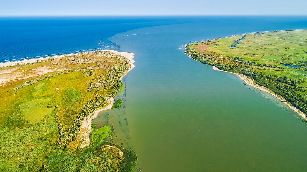
The Danube reaches its northernmost point at Regensburg, where it sharply turns southward, to the wide, level countryside, making the soils there, especially fertile. The Danube delta covers an area of some 4,300 sq. km. Located in the Tulcea County of Romania, it is comparatively young and continuously growing at a rate of 24 to 30 m annually towards the sea.
Life Within

Perhaps one of the most notable birds of the Danube is the great white pelican, 70% of the world’s which, live on the 4,300 sq. km large Danube Delta. Although protected by strict conservation laws, their sensitivity to even the minor of human disturbances when mating can make one flee to never return to the area again.
Another inhabitant of the river, the beaver prefers the calmer waters with rich aquatic vegetation. These animals are known for the construction of labyrinths of dams and canals, which other animals may occupy.
Other endangered species include Kingfishers, who reach their sexual maturity at the age of 1 and only live 2 years, and the professional swimmers but timid European pond turtles that get trapped in fishing weirs and drown. Some of the notable fish species that are found in the Danube River basin include pike, Wels catfish, tench, zander, burbot, sturgeon, salmon, trout, etc. Few Euryhaline fish species such as the European seabass, mullet, etc are found in lower parts of the river and the Danube Delta.
The unique flora of the Danube’s environment includes the somewhat smaller than other oak species - the pedunculate oaks, featuring a full-head of widespread leafy branches. There are also the delicate white-water lilies, the muse of the countless paintings by Monet. The water-loving clematis can be found in all shades of violet along the river’s banks.
Role In History

Sailing in the northern direction from Greece, sailors used the Danube River to conduct brisk trade in the 7th century BCE. In Roman times, the river was the north-most boundary of the Empire, called the Danuvius, controlled by a Roman fleet. The Middle Ages saw the erection of new castles by the Charlemagne (in the 9th century), while the Ottoman Empire used the string of old fortresses remaining from the Romans, for protection against the enemy, in the 15th century.
The river was repurposed from being a defense mechanism to an essential for trade, by the Queen of Hungary and Bohemia, Maria Theresa. Having established a department to oversee the river navigation between 1740 and 1780, it only commenced its duty as a trader’s path in 1830 by a riverboat from Vienna to Budapest.
The nations on the river were allowed to sail its course at different times and subject to various international agreements while regulating the navigation on the Danube has been the subject of many international agreements. The Anglo-Austrian and the Russo-Austrian conventions of 1838 and 1840, followed by the Treaty of Paris of 1856, all promoted free navigation that would give the river an international waterway status. By 1923, the final approval of the Danube River Statute was granted. It also established the international Danube Commission that controlled all aspects of navigating the Danube.
The beginning of the Second World War saw the interruption of the free international navigation along the Danube, until the Danubian Convention in 1948. Today, countless German warships remain behind from when they scattered around the waters to avoid being captured by the Soviet Union in 1944.
The Danube Today

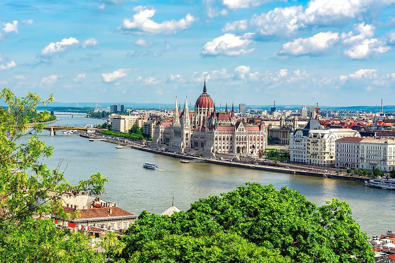
The Danube is indispensable to the economy of the 10 countries it traverses in many ways. All use the water’s great powers for freight transport, hydroelectricity, drinking water supplies, and fishing. The industrial use of the water prevails in Vienna, Budapest, Belgrade, and Ruse, while Slovakia, Hungary, Serbia, and Bulgaria are most dependent on it for irrigation. A recurring landmark on the postcards of Vienna, Budapest, and Belgrade, along with the bike trails and walking paths along the river all serve as a tourist attraction.
The immense volume of the river provides drinking water for millions of people in Central Europe, while also being utilized for hydroelectric power, especially, in the upper reaches. Unfortunately, pollution is getting in the way of many of the river’s uses, including becoming unfit for irrigation, diminished drinkable supply, and the depletion of fish.
Connecting the Atlantic Ocean with the Black Sea through the Bavarian Canal, the river continues to be the major shipping route through Europe. The Black Sea Canal is easily navigable, connecting Cernovadă, Romania to the Black Sea; the Main–Danube Canal links the Danube through the Rhine to the North Sea. Jointly erected by Yugoslavia and Romania, the Ðerdap (Djerdap) High Dam and the Iron Gate power station, cohesively produce hydroelectricity, as well as allow for ship navigation through the most difficult stretches of the river.