What Is Epicenter In Seismology?
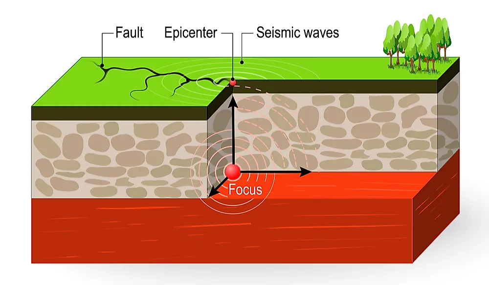
The epicenter is the point located directly above the focus. On the other hand, the focus is the fault that ruptures to form an earthquake. In most cases, earthquakes that are caused by a focus of less than 70 km turn out to be the most destructive. During an earthquake, fault slipping commences at the focus and stretches along the fault lines until it can no longer stretch due to strong rocks on its path. The magnitude of the earthquake is equivalent to the total area of its fault rapture. In earthquakes that exhibit high magnitudes, surface breaks are common. Fault ruptures can stretch as far as 100 km away. In seismology, experts can study the epicenter of an earthquake using a process known as triangulation.
Determining the Epicenter
Triangulation is the process of determining the location of something by using the location of other things or places. In the case of the epicenters, seismologists determine their positions through seismograms placed in a minimum of three different locations. Whenever there’s an earthquake, one can feel two waves in action. The first wave is known as the primary wave or compressional wave (simply called the P-wave). The second wave is the secondary wave which is simply referred to as the S-wave. These two waves are often used to determine the position of an epicenter by use of a seismometer. A seismometer records the time when the P-waves and S-waves arrive at a seismic station. Typically, P-waves travel faster than S-waves meaning they are recorded first. The difference between the arrival times of the two waves is known as the lag time or the epicentral distance. The greater the lag time, the further away the earthquake is and the shorter away the earthquake is from the seismic station.
Significance of Studying the Epicenter
Seismologists use seismographs to study epicenters so that they can understand the location of the faults and the crustal plate boundaries. Such information can be used to minimize damages caused by earthquakes. Examples of places that are currently located within major fault zones are California (United States), Los Angeles (United States), Japan, and Tokyo. Some of the worst earthquakes to have been experienced in the world include the 1994 Northridge Earthquake and the 2008 Sichuan earthquake. These earthquakes took place in California, US, and China respectively. In both scenarios, people lost their lives, property damages were valued at billions of dollars, and many people were injured. Giving warnings of impending earthquakes helps in minimizing the effects of the earthquakes.