Which Countries Border Zimbabwe?
Zimbabwe is a southern African landlocked country that is located right between Limpopo and Zambezi rivers. Zimbabwe is surrounded by Mozambique, Botswana, Zambia and South Africa. It has over 16 million residents. The locals converse in over sixteen dialects, but the most commonly used languages in Zimbabwe include Ndebele, Shona, and English. The country occupies an area of about 150,872 square miles, and its capital is Harare.
Present-day Zimbabwe has had numerous organized kingdoms and states since the eleventh century plus it was a major trade and migration route. The British South Africa Company demarcated the current territory in the 1890s, and by 1923 it became an autonomous British colony named Southern Rhodesia. Rhodesia became an independent state under the conservative white minority government in 1965. The country experienced guerilla war for fifteen years and international isolation which ended after the signing of a peace agreement and creation of Zimbabwe in 1980 with Robert Mugabe as the Prime Minister.
Zambia
Zambia is an autonomous state in South-central Africa which is surrounded by Mozambique, Angola, Namibia, Malawi, Botswana, Tanzania, the Democratic Republic of the Congo, and Zimbabwe. The population of Zambia is concentrated around the Copperbelt Province which is the country’s economic hub and Lusaka (the capital city). It is a landlocked state which occupies an area of about 290,587 square miles with a population of approximately 16,591,390 residents.The territory was a British Protectorate known as the North-Eastern Rhodesia, and Barotziland-North-Western Rhodesia during the nineteenth century. The two regions merged in 1911 to create the Northern Rhodesia. Zambia gained their independence on October 24, 1964, under Prime Minister Kaunda.
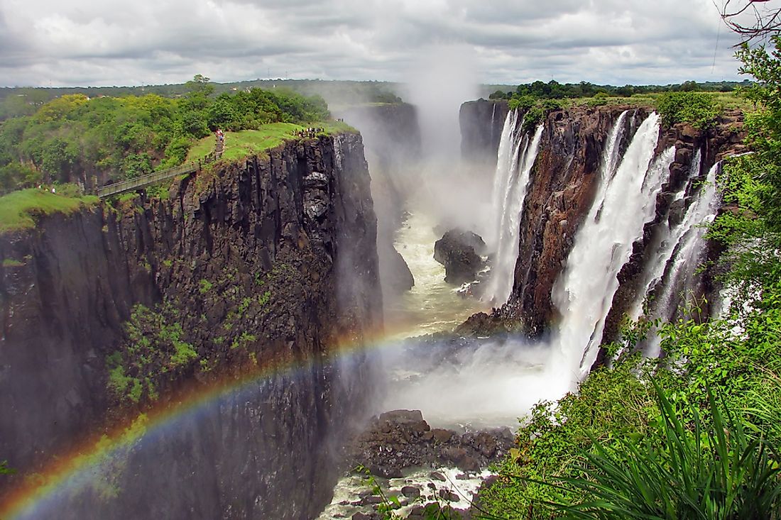
The 495 mile-long Zimbabwe-Zambia border is on the southern parts of Zambia. The border has numerous unique natural and artificial features including the Victoria Falls which UNESCO designated as a world heritage site. River Zambezi is the fourth longest river in Africa which forms part of the Zimbabwe-Zambia boundary. Lake Kariba is the biggest manmade lake in the world which forms part of the border. One of the border-crossings is the Victoria Falls Bridge which is right below Victoria Falls. Victoria Falls Bridge connects Zambia and Zimbabwe plus it has boundary posts at both ends. Another bridge which serves as a border-crossing is the Chirundu Bridge. Chirundu Bridge links Chirundu village, Zimbabwe, and Chirundu town.
South Africa
South Africa is the southernmost state in Africa with a 1,739 mile-long coastline which stretches along the Indian and South Atlantic oceans. South Africa is surrounded by Swaziland, Mozambique, Zimbabwe, Botswana, and Namibia. The country surrounds Lesotho kingdom. It is the twenty-fifth largest state in the world which occupies an area of about 471,445 square miles. South Africa is the southernmost nation of the Eastern Hemisphere which has over 56 million residents.
The 140 mile-long Zimbabwe-South Africa boundary follows River Limpopo’s median line. The border was established in 1881 by the Pretoria Convention and confirmed by the 1884 London Convention. The Botswana-Zimbabwe-South African tripoint is at the confluence of Limpopo and River Shashe. One of the main border crossings is at the Belf Bridge where the Zimbabwean A6 highway is connected to the N1 highway (South Africa) by the Alfred-Belt Road Bridge.
Botswana
Botswana is a Southern African landlocked state which was previously known as the Bechuanaland. It is topographically flat since the Kalahari Desert makes up over 70% of its territory. Botswana is bordered by Zambia, Zimbabwe, Namibia, and South Africa. Botswana is a mid-sized state occupies an area of about 224,610 square miles with over two million residents. It is a sparsely populated country with only 10% of the residents living in the capital city. The country adopted their current name after gaining their independence on September 30, 1966. Previously ranked among the poorest states on earth during the 1960s, the country’s economy has improved, and it is currently considered to be one of fastest growing state globally. Their economy is controlled by tourism, cattle, and mining.
The 505 mile-long Zimbabwe-Botswana border is on the northeastern parts of Botswana. The boundary has numerous crossing posts with Mpandamatenga being one of the oldest. Mapandamatenga, Zimbabwe is adjacent to an area known as Pandamatenga, Botswana. Another post is in the village of Ramokgwebana. The village is defined by River Ramokgwebana in Zimbabwe which is on the other side of the border.
Mozambique
Mozambique is a Southern African state which is separated from Madagascar, Mayotte and Comoros by the Mozambique Channel. The country is surrounded by Swaziland, Tanzania, Zimbabwe, South Africa, , Zambia, and Malawi. The Indian Ocean borders Mozambique to the eastern side. Maputo, the capital city of Mozambique, was previously called Lourenco Marques. The largest city in Mozambique is known as Matola.
The Bantu-speaking people migrated to Mozambique from the first to the fifth century AD. The Somali, Persian, and Arab merchants established a settlement and a commercial port in Mozambique in the eleventh century. Mozambique gained their independence in 1975. Two years after becoming an independent state, Mozambique descended into a protracted and intense civil war which ended in 1992. They had their first multi-party elections in 1994, and since then the country has been stable.
The 765 mile-long Mozambique-Zimbabwe boundary is on the western parts of Mozambique. One of the most commonly used border crossings between these two countries is the Machipanda. The border crossing is on the eastern parts of Mutare, Zimbabwe. Other border crossings are in Manica and Sango. Sango village is on the Mozambique-Zimbabwe boundary, and it supports the border post which is at the southernmost end of Gonarezhou National park, Zimbabwe. The border post connects with Chicualacuala town in Mozambique.


